You are here: Home > Network List > TA - USArray Transportable Network (new EarthScope stations) Stations List
> Station S61A Accomac, VA, USA > Earthquake Result Viewer
S61A Accomac, VA, USA - Earthquake Result Viewer
| Earthquake location: |
Near Coast Of Northern Chile |
| Earthquake latitude/longitude: |
-19.9/-70.6 |
| Earthquake time(UTC): |
2014/03/16 (075) 21:16:30 GMT |
| Earthquake Depth: |
20 km |
| Earthquake Magnitude: |
6.7 MWW, 6.7 MWC, 7.0 MI |
| Earthquake Catalog/Contributor: |
NEIC PDE/NEIC COMCAT |
|
| Network: |
TA USArray Transportable Network (new EarthScope stations) |
| Station: |
S61A Accomac, VA, USA |
| Lat/Lon: |
37.68 N/75.67 W |
| Elevation: |
58 m |
|
| Distance: |
57.5 deg |
| Az: |
355.254 deg |
| Baz: |
174.37 deg |
| Ray Param: |
0.063433096 |
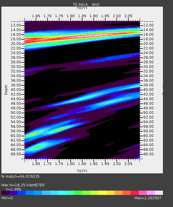
| Estimated Moho Depth: |
16.25 km |
| Estimated Crust Vp/Vs: |
1.89 |
| Assumed Crust Vp: |
5.817 km/s |
| Estimated Crust Vs: |
3.07 km/s |
| Estimated Crust Poisson's Ratio: |
0.31 |
|
| Radial Match: |
84.019035 % |
| Radial Bump: |
400 |
| Transverse Match: |
66.42376 % |
| Transverse Bump: |
400 |
| SOD ConfigId: |
626651 |
| Insert Time: |
2014-04-21 07:44:12.681 +0000 |
| GWidth: |
2.5 |
| Max Bumps: |
400 |
| Tol: |
0.001 |
|
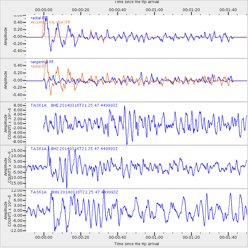
Signal To Noise
| Channel | StoN | STA | LTA |
| TA:S61A: :BHZ:20140316T21:25:47.449993Z | 2.2023942 | 6.782441E-6 | 3.079576E-6 |
| TA:S61A: :BHN:20140316T21:25:47.449993Z | 2.5125904 | 4.286848E-6 | 1.7061467E-6 |
| TA:S61A: :BHE:20140316T21:25:47.449993Z | 0.97103953 | 2.0070183E-6 | 2.066876E-6 |
| Arrivals |
| Ps | 2.6 SECOND |
| PpPs | 7.8 SECOND |
| PsPs/PpSs | 10 SECOND |


