You are here: Home > Network List > TA - USArray Transportable Network (new EarthScope stations) Stations List
> Station S61A Accomac, VA, USA > Earthquake Result Viewer
S61A Accomac, VA, USA - Earthquake Result Viewer
| Earthquake location: |
Near Coast Of Northern Chile |
| Earthquake latitude/longitude: |
-19.6/-70.8 |
| Earthquake time(UTC): |
2014/04/01 (091) 23:46:46 GMT |
| Earthquake Depth: |
20 km |
| Earthquake Magnitude: |
8.2 MWW, 8.0 MI, 8.1 MWC |
| Earthquake Catalog/Contributor: |
NEIC PDE/NEIC COMCAT |
|
| Network: |
TA USArray Transportable Network (new EarthScope stations) |
| Station: |
S61A Accomac, VA, USA |
| Lat/Lon: |
37.68 N/75.67 W |
| Elevation: |
58 m |
|
| Distance: |
57.2 deg |
| Az: |
355.417 deg |
| Baz: |
174.554 deg |
| Ray Param: |
0.06362073 |
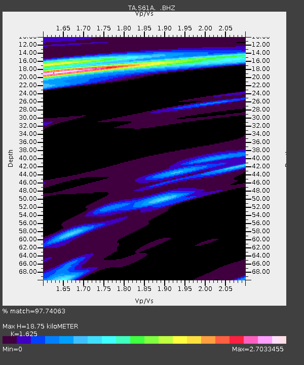
| Estimated Moho Depth: |
18.75 km |
| Estimated Crust Vp/Vs: |
1.62 |
| Assumed Crust Vp: |
5.817 km/s |
| Estimated Crust Vs: |
3.58 km/s |
| Estimated Crust Poisson's Ratio: |
0.20 |
|
| Radial Match: |
97.74063 % |
| Radial Bump: |
343 |
| Transverse Match: |
86.49593 % |
| Transverse Bump: |
400 |
| SOD ConfigId: |
626651 |
| Insert Time: |
2014-04-21 19:07:21.048 +0000 |
| GWidth: |
2.5 |
| Max Bumps: |
400 |
| Tol: |
0.001 |
|
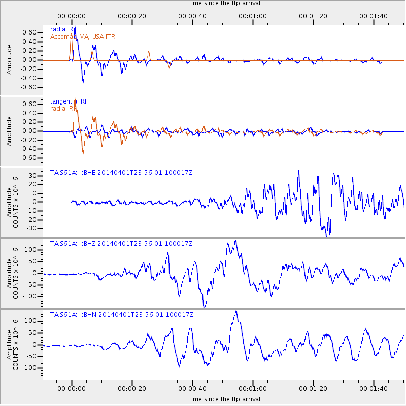
Signal To Noise
| Channel | StoN | STA | LTA |
| TA:S61A: :BHZ:20140401T23:56:01.100017Z | 2.2743561 | 2.8196653E-6 | 1.2397643E-6 |
| TA:S61A: :BHN:20140401T23:56:01.100017Z | 1.8369067 | 2.6378184E-6 | 1.4360111E-6 |
| TA:S61A: :BHE:20140401T23:56:01.100017Z | 0.93692845 | 1.0183186E-6 | 1.0868691E-6 |
| Arrivals |
| Ps | 2.1 SECOND |
| PpPs | 8.1 SECOND |
| PsPs/PpSs | 10 SECOND |


