You are here: Home > Network List > IC - New China Digital Seismograph Network Stations List
> Station HIA Hailar, Neimenggu Autonomous Region, China > Earthquake Result Viewer
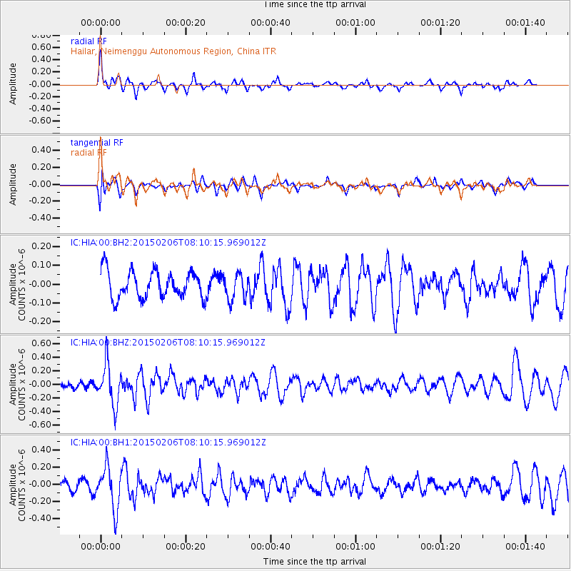
HIA Hailar, Neimenggu Autonomous Region, China - Earthquake Result Viewer
*The percent match for this event was below the threshold and hence no stack was calculated.
| Earthquake location: |
Mindanao, Philippines |
| Earthquake latitude/longitude: |
9.6/126.4 |
| Earthquake time(UTC): |
2015/02/06 (037) 08:03:17 GMT |
| Earthquake Depth: |
58 km |
| Earthquake Magnitude: |
5.4 MW |
| Earthquake Catalog/Contributor: |
ISC/ISC |
|
| Network: |
IC New China Digital Seismograph Network |
| Station: |
HIA Hailar, Neimenggu Autonomous Region, China |
| Lat/Lon: |
49.27 N/119.74 E |
| Elevation: |
620 m |
|
| Distance: |
39.9 deg |
| Az: |
353.234 deg |
| Baz: |
169.783 deg |
| Ray Param: |
$rayparam |
*The percent match for this event was below the threshold and hence was not used in the summary stack. |
|
| Radial Match: |
69.131615 % |
| Radial Bump: |
400 |
| Transverse Match: |
35.347588 % |
| Transverse Bump: |
400 |
| SOD ConfigId: |
7019011 |
| Insert Time: |
2019-04-16 16:45:13.265 +0000 |
| GWidth: |
2.5 |
| Max Bumps: |
400 |
| Tol: |
0.001 |
|
Signal To Noise
| Channel | StoN | STA | LTA |
| IC:HIA:00:BHZ:20150206T08:10:15.969012Z | 3.2757914 | 3.075884E-7 | 9.3897434E-8 |
| IC:HIA:00:BH1:20150206T08:10:15.969012Z | 4.9255905 | 2.5480986E-7 | 5.1731842E-8 |
| IC:HIA:00:BH2:20150206T08:10:15.969012Z | 0.97015023 | 6.957165E-8 | 7.171224E-8 |
| Arrivals |
| Ps | |
| PpPs | |
| PsPs/PpSs | |


