You are here: Home > Network List > TA - USArray Transportable Network (new EarthScope stations) Stations List
> Station N63A Mattituck, NY, USA > Earthquake Result Viewer
N63A Mattituck, NY, USA - Earthquake Result Viewer
| Earthquake location: |
Guerrero, Mexico |
| Earthquake latitude/longitude: |
17.6/-100.8 |
| Earthquake time(UTC): |
2014/04/18 (108) 14:27:26 GMT |
| Earthquake Depth: |
24 km |
| Earthquake Magnitude: |
7.2 MWW, 7.0 MWB, 7.3 MWC, 7.5 MI |
| Earthquake Catalog/Contributor: |
NEIC PDE/NEIC COMCAT |
|
| Network: |
TA USArray Transportable Network (new EarthScope stations) |
| Station: |
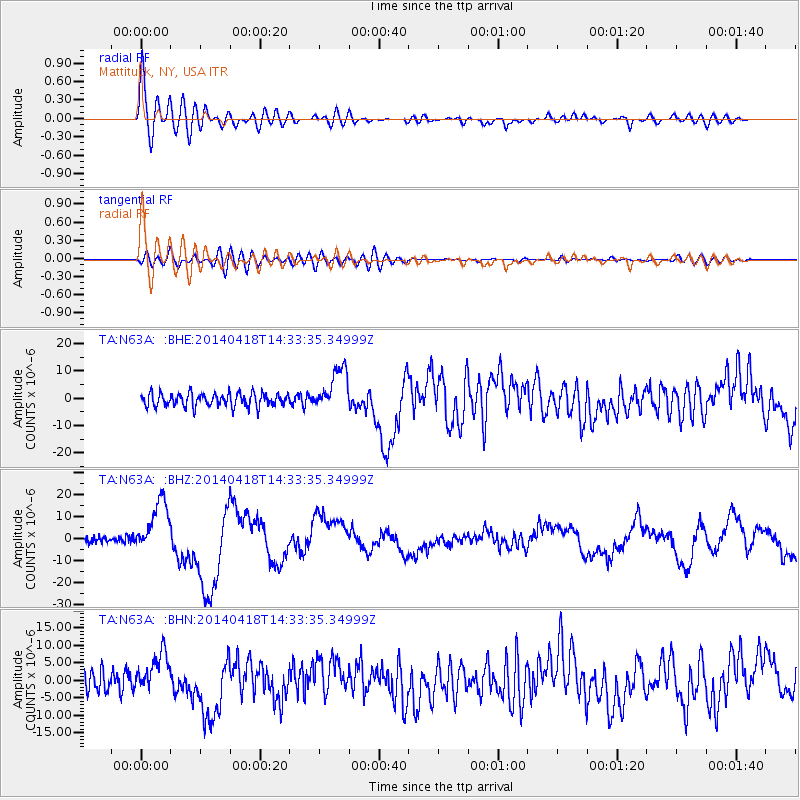
N63A Mattituck, NY, USA |
| Lat/Lon: |
40.99 N/72.52 W |
| Elevation: |
8.0 m |
|
| Distance: |
33.7 deg |
| Az: |
40.272 deg |
| Baz: |
234.551 deg |
| Ray Param: |
0.07804706 |
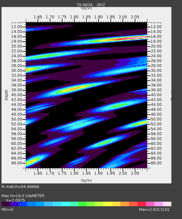
| Estimated Moho Depth: |
16.0 km |
| Estimated Crust Vp/Vs: |
2.10 |
| Assumed Crust Vp: |
6.472 km/s |
| Estimated Crust Vs: |
3.086 km/s |
| Estimated Crust Poisson's Ratio: |
0.35 |
|
| Radial Match: |
84.66666 % |
| Radial Bump: |
400 |
| Transverse Match: |
46.075573 % |
| Transverse Bump: |
400 |
| SOD ConfigId: |
626651 |
| Insert Time: |
2014-05-02 15:11:21.582 +0000 |
| GWidth: |
2.5 |
| Max Bumps: |
400 |
| Tol: |
0.001 |
|
Signal To Noise
| Channel | StoN | STA | LTA |
| TA:N63A: :BHZ:20140418T14:33:35.34999Z | 9.127722 | 1.19506585E-5 | 1.3092707E-6 |
| TA:N63A: :BHN:20140418T14:33:35.34999Z | 2.6189616 | 5.633915E-6 | 2.151202E-6 |
| TA:N63A: :BHE:20140418T14:33:35.34999Z | 3.2196324 | 7.761474E-6 | 2.410671E-6 |
| Arrivals |
| Ps | 2.9 SECOND |
| PpPs | 7.2 SECOND |
| PsPs/PpSs | 10 SECOND |


