
Station TA N63A - Mattituck, NY, USA
Network: TA - USArray Transportable Network (new EarthScope stations)
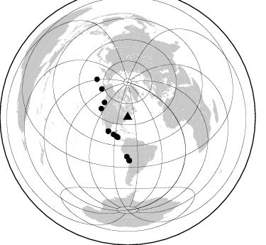
Nearby stations (2 deg radius)
| Station | Name | (Lat, Lon) | Start / End | Elevation |
| N63A | Mattituck, NY, USA | (40.99, -72.52) | 2013-09-10 / 2599-12-31 | 8.0 m |
| Crust2 Type: | T6,Margin /shield transition, 1 km seds. |
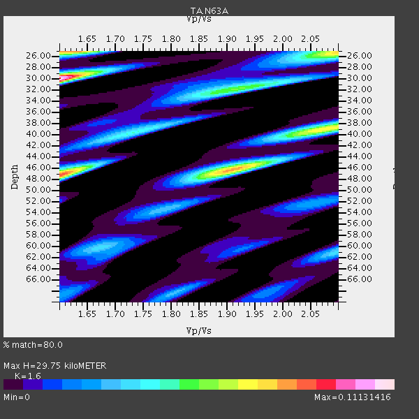
| Thickness Estimate: | 30 km |
| Thickness StdDev: | 7.5 km |
| Vp/Vs Estimate: | 1.60 |
| Vp/Vs StdDev: | 0.18 |
| Vs Estimate: | 4.045 km/s |
| Poisson's Ratio: | 0.18 |
| Peak Value: | 0.11 |
| Assumed Vp: | 6.472 km/s |
| Ps Weight: | 0.33333334 |
| PpPs Weight: | 0.33333334 |
| PsPs Weight: | 0.33333328 |
| Residual Complexity: | 0.921 |
| Nearby stations H: | +- |
| (2.0 deg) Vp/Vs: | +- |
5 with match > 90% ( 20.833334 %) and 14 with match > 80% ( 58.333332 %) out of 24.
Download stack as xyz text file.
Azimuth Distribution of Events:
Prior Results for this Station
| Study | Thickness | Vp/Vs | Vp | Vs | Poissons Ratio | Extra |
| EARS | 30 km | 1.60 | 6.472 km/s | 4.045 km/s | 0.18 | |
| Crust2.0 | 32 km | 1.79 | 6.472 km/s | 3.622 km/s | 0.27 | T6,Margin /shield transition, 1 km seds. |
| Global Maxima | 30 km | 1.60 | 6.472 km/s | 4.045 km/s | 0.18 | amp=0.11131416 |
| Local Maxima 1 | 47 km | 1.60 | 6.472 km/s | 4.039 km/s | 0.18 | amp=0.08847197 |
| Local Maxima 2 | 25 km | 1.62 | 6.472 km/s | 4.001 km/s | 0.19 | amp=0.08189693 |
| Local Maxima 3 | 46 km | 1.90 | 6.472 km/s | 3.397 km/s | 0.31 | amp=0.080285445 |
| Local Maxima 4 | 32 km | 1.91 | 6.472 km/s | 3.384 km/s | 0.31 | amp=0.05631263 |
| Predicted Arrivals for vertical incidence (zero ray parameter) | |
| Ps | 2.76 SECOND |
| PpPs | 11.95 SECOND |
| PsPs/PpSs | 14.71 SECOND |
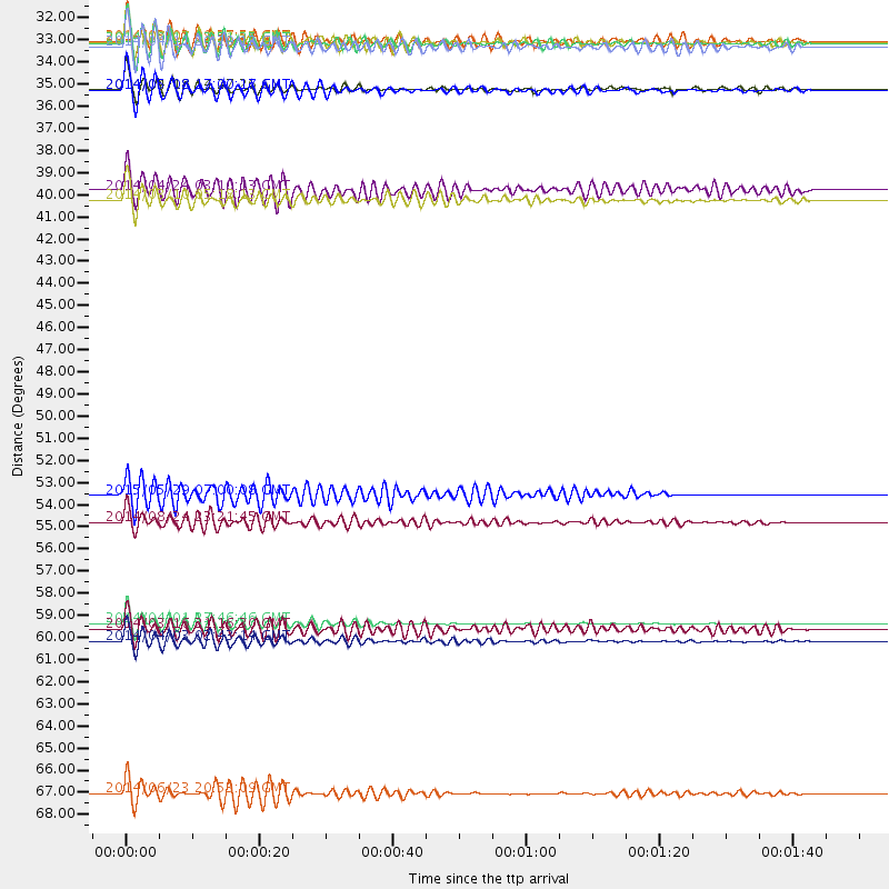
Events Processed for this Station
Download zip of receiver functions as SAC
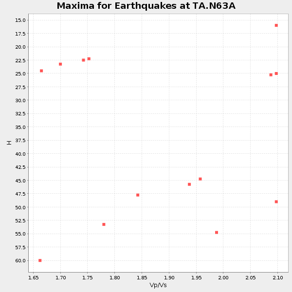
Plot maxima for each earthquake.
Events Used in the Stack
(14 events)| Radial Match | Distance | Baz | FERegion | Time | Lat/Lon | Depth | Magnitude |
| 93.38696 | 60.3 deg | 178.152 deg | Near Coast Of Northern Chile | 2014/04/01 23:46:46 GMT | (-19.6, -70.8) | 20 km | 8.2 MWW, 8.0 MI, 8.1 MWC |
| 93.31874 | 61.2 deg | 177.837 deg | Near Coast Of Northern Chile | 2014/04/03 02:43:14 GMT | (-20.5, -70.5) | 31 km | 7.7 MWW, 7.4 MI, 7.7 MWC |
| 92.68542 | 68.8 deg | 320.894 deg | Rat Islands, Aleutian Islands | 2014/06/23 20:53:09 GMT | (51.8, 178.8) | 108 km | 7.9 MWW, 7.1 MI, 7.9 MWC |
| 91.36113 | 31.4 deg | 210.099 deg | Off Coast Of Central America | 2014/10/14 03:51:35 GMT | (12.6, -88.0) | 40 km | 7.3 MWW, 7.4 MI |
| 90.240555 | 53.9 deg | 317.261 deg | Alaska Peninsula | 2015/05/29 07:00:08 GMT | (56.7, -156.5) | 62 km | 6.8 MWP, 6.8 MI |
| 89.644875 | 39.3 deg | 287.662 deg | Off Coast Of Northern California | 2014/03/10 05:18:13 GMT | (40.8, -125.1) | 17 km | 6.8 MW, 6.8 MWR, 6.9 MWW, 6.9 MWB, 7.0 MI, 7.0 MWC |
| 89.051315 | 33.7 deg | 234.148 deg | Guerrero, Mexico | 2014/05/08 17:00:17 GMT | (17.4, -100.7) | 24 km | 6.4 MWW, 6.8 MI |
| 87.57621 | 31.6 deg | 205.918 deg | Near Coast Of Nicaragua | 2014/04/11 20:29:13 GMT | (11.6, -86.0) | 135 km | 6.6 MWW, 6.6 MWC, 6.6 MWB, 6.6 MI |
| 85.31094 | 38.8 deg | 302.221 deg | Vancouver Island, Canada Region | 2014/04/24 03:10:13 GMT | (49.8, -127.4) | 11 km | 6.7 MWP, 6.7 MI |
| 84.66666 | 33.7 deg | 234.551 deg | Guerrero, Mexico | 2014/04/18 14:27:26 GMT | (17.6, -100.8) | 24 km | 7.2 MWW, 7.0 MWB, 7.3 MWC, 7.5 MI |
| 84.53255 | 55.3 deg | 181.245 deg | Central Peru | 2014/08/24 23:21:45 GMT | (-14.6, -73.6) | 101 km | 6.9 MWW, 6.8 MI, 6.9 MWB |
| 82.756294 | 60.6 deg | 177.956 deg | Near Coast Of Northern Chile | 2014/03/16 21:16:30 GMT | (-19.9, -70.6) | 20 km | 6.7 MWW, 6.7 MWC, 7.0 MI |
| 82.478134 | 31.4 deg | 219.237 deg | Near Coast Of Chiapas, Mexico | 2014/07/07 11:23:55 GMT | (14.7, -92.4) | 60 km | 6.9 MWW, 6.9 MWC, 7.1 MI |
| 81.9425 | 31.3 deg | 209.459 deg | Near Coast Of Nicaragua | 2014/03/02 09:37:54 GMT | (12.6, -87.7) | 60 km | 6.2 MWW, 6.2 MWB, 6.2 MWC, 6.3 MWC |
Losers
(10 events)| Radial Match | Distance | Baz | FERegion | Time | Lat/Lon | Depth | Magnitude | Reason |
| 76.95274 | 34.0 deg | 180.871 deg | Northern Colombia | 2015/03/10 20:55:43 GMT | (6.8, -73.0) | 147 km | 6.2 MWB | |
| 73.88069 | 87.1 deg | 331.874 deg | Kuril Islands | 2014/07/20 18:32:47 GMT | (44.6, 148.7) | 61 km | 6.6 MB | |
| 67.84726 | 33.9 deg | 234.137 deg | Guerrero, Mexico | 2014/05/10 07:36:03 GMT | (17.3, -100.8) | 35 km | 6.0 MB | |
| 61.06025 | 78.4 deg | 334.11 deg | Sea Of Okhotsk | 2013/10/01 03:38:21 GMT | (53.2, 152.8) | 573 km | 6.7 MWW, 6.7 MWC, 6.8 MWC, 6.8 MWB | |
| 59.0399 | 64.0 deg | 174.027 deg | Jujuy Province, Argentina | 2015/02/11 18:57:22 GMT | (-23.1, -66.7) | 223 km | 6.7 MWW, 6.7 MWC, 6.7 MWB, 6.9 MI | |
| 58.12771 | 60.2 deg | 177.44 deg | Near Coast Of Northern Chile | 2014/04/01 23:59:57 GMT | (-19.5, -70.2) | 22 km | 5.8 MB | |
| 57.273464 | 32.1 deg | 219.89 deg | Near Coast Of Chiapas, Mexico | 2014/03/02 22:26:10 GMT | (14.2, -93.1) | 36 km | 5.4 MW | |
| 55.692883 | 70.0 deg | 179.333 deg | Near Coast Of Central Chile | 2015/04/01 08:17:26 GMT | (-29.3, -71.8) | 21 km | 5.5 MB | |
| 52.32337 | 91.3 deg | 335.687 deg | Hokkaido, Japan Region | 2014/07/08 09:05:23 GMT | (42.7, 141.4) | 10 km | 5.6 MB, 5.5 MWB | |
| 44.22738 | 74.3 deg | 217.831 deg | Easter Island Region | 2013/11/02 15:52:46 GMT | (-23.6, -112.6) | 10 km | 6.0 MWW, 5.9 MWB, 6.0 MWW, 6.0 MWC, 6.1 MWC |

