You are here: Home > Network List > TA - USArray Transportable Network (new EarthScope stations) Stations List
> Station N63A Mattituck, NY, USA > Earthquake Result Viewer
N63A Mattituck, NY, USA - Earthquake Result Viewer
| Earthquake location: |
Vancouver Island, Canada Region |
| Earthquake latitude/longitude: |
49.8/-127.4 |
| Earthquake time(UTC): |
2014/04/24 (114) 03:10:13 GMT |
| Earthquake Depth: |
11 km |
| Earthquake Magnitude: |
6.7 MWP, 6.7 MI |
| Earthquake Catalog/Contributor: |
NEIC PDE/NEIC COMCAT |
|
| Network: |
TA USArray Transportable Network (new EarthScope stations) |
| Station: |
N63A Mattituck, NY, USA |
| Lat/Lon: |
40.99 N/72.52 W |
| Elevation: |
8.0 m |
|
| Distance: |
38.8 deg |
| Az: |
81.621 deg |
| Baz: |
302.221 deg |
| Ray Param: |
0.075371735 |
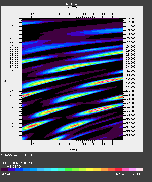
| Estimated Moho Depth: |
54.75 km |
| Estimated Crust Vp/Vs: |
1.99 |
| Assumed Crust Vp: |
6.472 km/s |
| Estimated Crust Vs: |
3.256 km/s |
| Estimated Crust Poisson's Ratio: |
0.33 |
|
| Radial Match: |
85.31094 % |
| Radial Bump: |
400 |
| Transverse Match: |
59.678783 % |
| Transverse Bump: |
400 |
| SOD ConfigId: |
626651 |
| Insert Time: |
2014-05-08 04:15:02.898 +0000 |
| GWidth: |
2.5 |
| Max Bumps: |
400 |
| Tol: |
0.001 |
|
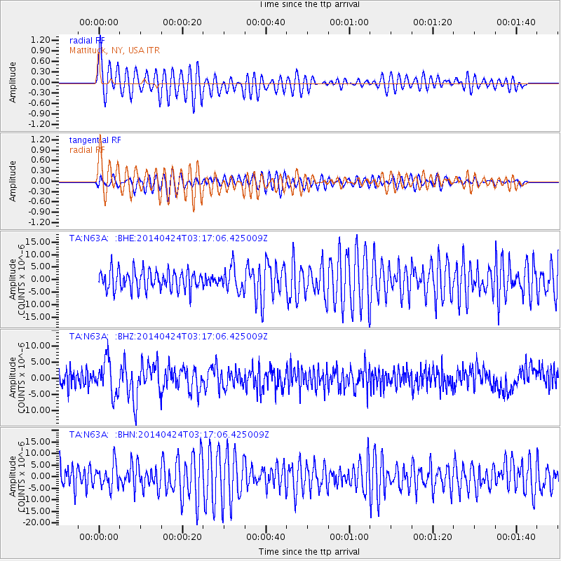
Signal To Noise
| Channel | StoN | STA | LTA |
| TA:N63A: :BHZ:20140424T03:17:06.425009Z | 2.034599 | 5.39397E-6 | 2.6511216E-6 |
| TA:N63A: :BHN:20140424T03:17:06.425009Z | 1.1378812 | 5.054032E-6 | 4.4416165E-6 |
| TA:N63A: :BHE:20140424T03:17:06.425009Z | 1.2331266 | 4.7211183E-6 | 3.8285752E-6 |
| Arrivals |
| Ps | 8.9 SECOND |
| PpPs | 24 SECOND |
| PsPs/PpSs | 33 SECOND |


