You are here: Home > Network List > IC - New China Digital Seismograph Network Stations List
> Station HIA Hailar, Neimenggu Autonomous Region, China > Earthquake Result Viewer
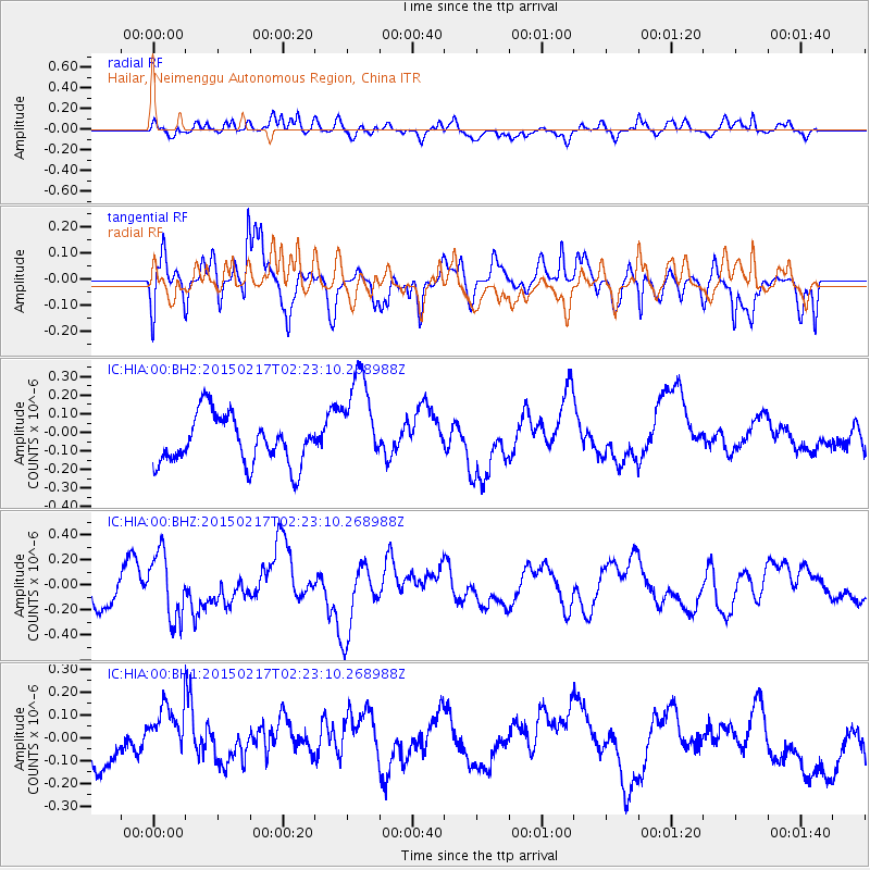
HIA Hailar, Neimenggu Autonomous Region, China - Earthquake Result Viewer
*The percent match for this event was below the threshold and hence no stack was calculated.
| Earthquake location: |
Northern Molucca Sea |
| Earthquake latitude/longitude: |
0.5/126.1 |
| Earthquake time(UTC): |
2015/02/17 (048) 02:14:59 GMT |
| Earthquake Depth: |
46 km |
| Earthquake Magnitude: |
5.5 MW |
| Earthquake Catalog/Contributor: |
ISC/ISC |
|
| Network: |
IC New China Digital Seismograph Network |
| Station: |
HIA Hailar, Neimenggu Autonomous Region, China |
| Lat/Lon: |
49.27 N/119.74 E |
| Elevation: |
620 m |
|
| Distance: |
48.9 deg |
| Az: |
354.463 deg |
| Baz: |
171.529 deg |
| Ray Param: |
$rayparam |
*The percent match for this event was below the threshold and hence was not used in the summary stack. |
|
| Radial Match: |
56.517353 % |
| Radial Bump: |
400 |
| Transverse Match: |
71.299385 % |
| Transverse Bump: |
400 |
| SOD ConfigId: |
7019011 |
| Insert Time: |
2019-04-16 21:05:02.726 +0000 |
| GWidth: |
2.5 |
| Max Bumps: |
400 |
| Tol: |
0.001 |
|
Signal To Noise
| Channel | StoN | STA | LTA |
| IC:HIA:00:BHZ:20150217T02:23:10.268988Z | 1.6600721 | 2.6469624E-7 | 1.5944863E-7 |
| IC:HIA:00:BH1:20150217T02:23:10.268988Z | 1.3027095 | 1.1846316E-7 | 9.0935984E-8 |
| IC:HIA:00:BH2:20150217T02:23:10.268988Z | 2.061305 | 2.6604695E-7 | 1.2906725E-7 |
| Arrivals |
| Ps | |
| PpPs | |
| PsPs/PpSs | |


