You are here: Home > Network List > NE - New England Seismic Network Stations List
> Station ORNO Orno, ME, USA > Earthquake Result Viewer
ORNO Orno, ME, USA - Earthquake Result Viewer
| Earthquake location: |
Near Coast Of Guerrero, Mexico |
| Earthquake latitude/longitude: |
16.5/-98.1 |
| Earthquake time(UTC): |
2014/05/24 (144) 08:24:47 GMT |
| Earthquake Depth: |
17 km |
| Earthquake Magnitude: |
5.7 MWW, 5.6 MWB, 5.7 MWC |
| Earthquake Catalog/Contributor: |
NEIC PDE/NEIC COMCAT |
|
| Network: |
NE New England Seismic Network |
| Station: |
ORNO Orno, ME, USA |
| Lat/Lon: |
44.90 N/68.66 W |
| Elevation: |
40 m |
|
| Distance: |
37.6 deg |
| Az: |
34.972 deg |
| Baz: |
230.683 deg |
| Ray Param: |
0.0760303 |
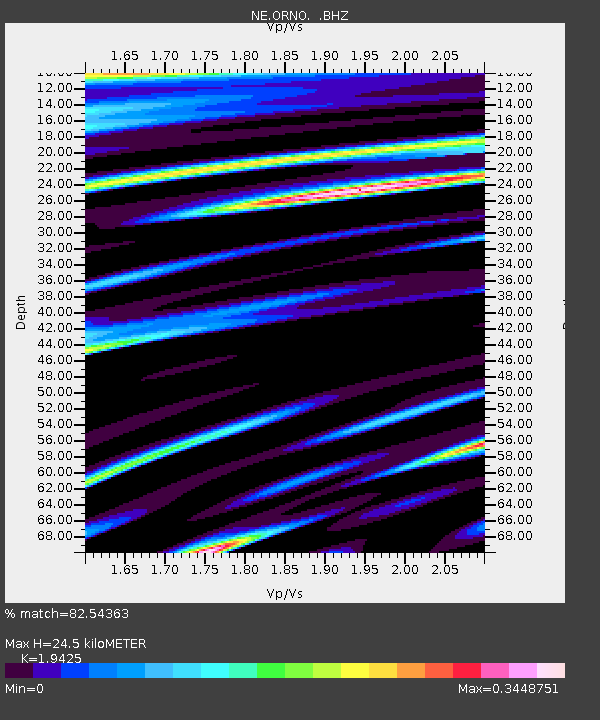
| Estimated Moho Depth: |
24.5 km |
| Estimated Crust Vp/Vs: |
1.94 |
| Assumed Crust Vp: |
6.419 km/s |
| Estimated Crust Vs: |
3.305 km/s |
| Estimated Crust Poisson's Ratio: |
0.32 |
|
| Radial Match: |
82.54363 % |
| Radial Bump: |
400 |
| Transverse Match: |
61.782616 % |
| Transverse Bump: |
400 |
| SOD ConfigId: |
626651 |
| Insert Time: |
2014-06-12 09:53:15.134 +0000 |
| GWidth: |
2.5 |
| Max Bumps: |
400 |
| Tol: |
0.001 |
|

Signal To Noise
| Channel | StoN | STA | LTA |
| NE:ORNO: :BHZ:20140524T08:31:30.829996Z | 2.8068638 | 4.248313E-7 | 1.5135446E-7 |
| NE:ORNO: :BHN:20140524T08:31:30.829996Z | 0.8900396 | 1.3524065E-7 | 1.5194902E-7 |
| NE:ORNO: :BHE:20140524T08:31:30.829996Z | 1.7260597 | 2.4306212E-7 | 1.4081907E-7 |
| Arrivals |
| Ps | 3.8 SECOND |
| PpPs | 11 SECOND |
| PsPs/PpSs | 14 SECOND |


