You are here: Home > Network List > TA - USArray Transportable Network (new EarthScope stations) Stations List
> Station L65A Cape Cod National Seashore, MA, USA > Earthquake Result Viewer
L65A Cape Cod National Seashore, MA, USA - Earthquake Result Viewer
| Earthquake location: |
Northern Colombia |
| Earthquake latitude/longitude: |
6.8/-73.0 |
| Earthquake time(UTC): |
2015/03/10 (069) 20:55:43 GMT |
| Earthquake Depth: |
147 km |
| Earthquake Magnitude: |
6.2 MWB |
| Earthquake Catalog/Contributor: |
NEIC PDE/NEIC COMCAT |
|
| Network: |
TA USArray Transportable Network (new EarthScope stations) |
| Station: |
L65A Cape Cod National Seashore, MA, USA |
| Lat/Lon: |
42.03 N/70.05 W |
| Elevation: |
50 m |
|
| Distance: |
35.2 deg |
| Az: |
3.829 deg |
| Baz: |
185.107 deg |
| Ray Param: |
0.076861866 |
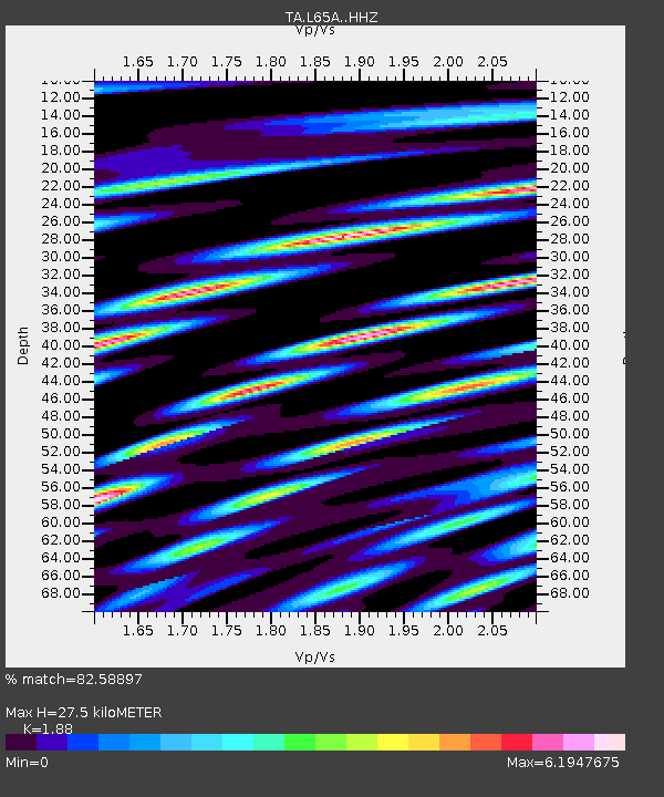
| Estimated Moho Depth: |
27.5 km |
| Estimated Crust Vp/Vs: |
1.88 |
| Assumed Crust Vp: |
6.419 km/s |
| Estimated Crust Vs: |
3.414 km/s |
| Estimated Crust Poisson's Ratio: |
0.30 |
|
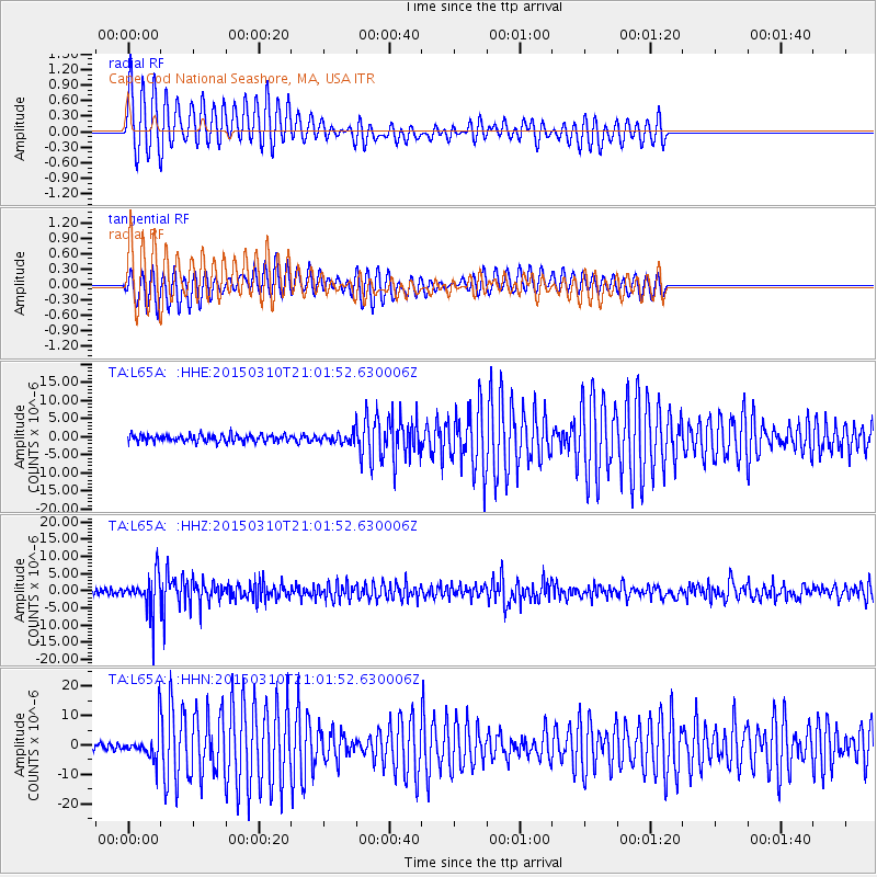
| Radial Match: |
82.58897 % |
| Radial Bump: |
400 |
| Transverse Match: |
77.099434 % |
| Transverse Bump: |
400 |
| SOD ConfigId: |
7019011 |
| Insert Time: |
2019-04-17 07:02:07.172 +0000 |
| GWidth: |
2.5 |
| Max Bumps: |
400 |
| Tol: |
0.001 |
|
Signal To Noise
| Channel | StoN | STA | LTA |
| TA:L65A: :HHZ:20150310T21:01:52.630006Z | 7.56932 | 5.4828265E-6 | 7.243486E-7 |
| TA:L65A: :HHN:20150310T21:01:52.630006Z | 5.2896137 | 4.98739E-6 | 9.428647E-7 |
| TA:L65A: :HHE:20150310T21:01:52.630006Z | 1.1601448 | 1.1544342E-6 | 9.950777E-7 |
| Arrivals |
| Ps | 4.0 SECOND |
| PpPs | 11 SECOND |
| PsPs/PpSs | 16 SECOND |


