
Station TA L65A - Cape Cod National Seashore, MA, USA
Network: TA - USArray Transportable Network (new EarthScope stations)
Nearby stations (2 deg radius)
| Station | Name | (Lat, Lon) | Start / End | Elevation |
| L65A | Cape Cod National Seashore, MA, USA | (42.03, -70.05) | 2013-09-27 / 2599-12-31 | 50 m |
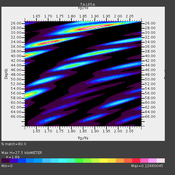
| Crust2 Type: | Q2,orogen/39km no ice, Appalachians, North Andes, 0.5 km seds. |
| Thickness Estimate: | 28 km |
| Thickness StdDev: | 6.8 km |
| Vp/Vs Estimate: | 1.89 |
| Vp/Vs StdDev: | 0.12 |
| Vs Estimate: | 3.396 km/s |
| Poisson's Ratio: | 0.31 |
| Peak Value: | 0.14 |
| Assumed Vp: | 6.419 km/s |
| Ps Weight: | 0.33333334 |
| PpPs Weight: | 0.33333334 |
| PsPs Weight: | 0.33333328 |
| Residual Complexity: | 0.717 |
| Nearby stations H: | +- |
| (2.0 deg) Vp/Vs: | +- |
0 with match > 90% ( 0.0 %) and 12 with match > 80% ( 54.545456 %) out of 22.
Download stack as xyz text file.
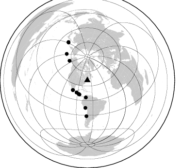
Azimuth Distribution of Events:
Prior Results for this Station
| Study | Thickness | Vp/Vs | Vp | Vs | Poissons Ratio | Extra |
| EARS | 28 km | 1.89 | 6.419 km/s | 3.396 km/s | 0.31 | |
| Crust2.0 | 39 km | 1.75 | 6.419 km/s | 3.659 km/s | 0.26 | Q2,orogen/39km no ice, Appalachians, North Andes, 0.5 km seds. |
| Global Maxima | 28 km | 1.89 | 6.419 km/s | 3.396 km/s | 0.31 | amp=0.13660045 |
| Local Maxima 1 | 34 km | 1.69 | 6.419 km/s | 3.804 km/s | 0.23 | amp=0.10552834 |
| Local Maxima 2 | 56 km | 1.61 | 6.419 km/s | 3.987 km/s | 0.19 | amp=0.08866153 |
| Local Maxima 3 | 40 km | 1.60 | 6.419 km/s | 4.012 km/s | 0.18 | amp=0.082570046 |
| Local Maxima 4 | 38 km | 1.92 | 6.419 km/s | 3.339 km/s | 0.31 | amp=0.07396994 |
| Predicted Arrivals for vertical incidence (zero ray parameter) | |
| Ps | 3.81 SECOND |
| PpPs | 12.38 SECOND |
| PsPs/PpSs | 16.19 SECOND |
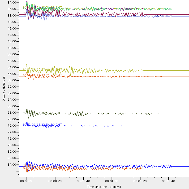
Events Processed for this Station
Download zip of receiver functions as SAC
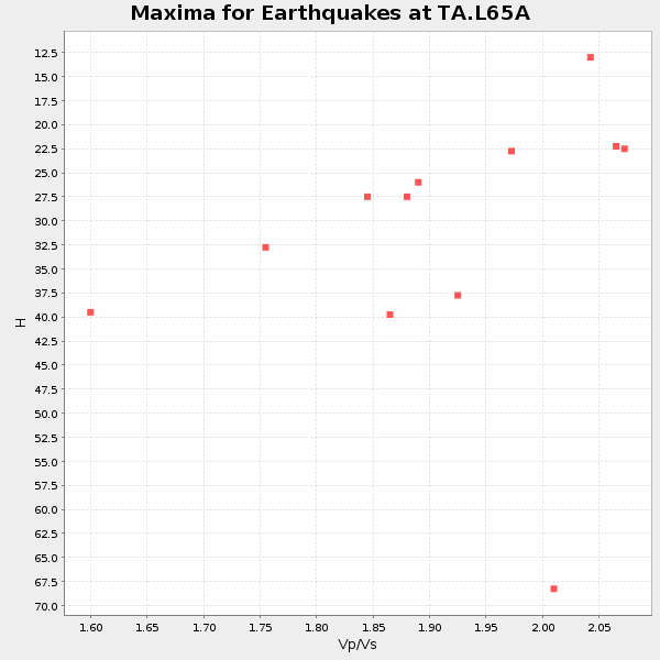
Plot maxima for each earthquake.
Events Used in the Stack
(12 events)| Radial Match | Distance | Baz | FERegion | Time | Lat/Lon | Depth | Magnitude |
| 88.26781 | 33.3 deg | 213.354 deg | Off Coast Of Central America | 2014/10/14 03:51:35 GMT | (12.6, -88.0) | 40 km | 7.3 MWW, 7.4 MI |
| 87.625145 | 35.8 deg | 236.457 deg | Guerrero, Mexico | 2014/04/18 14:27:26 GMT | (17.6, -100.8) | 24 km | 7.2 MWW, 7.0 MWB, 7.3 MWC, 7.5 MI |
| 87.508995 | 87.8 deg | 333.601 deg | Kuril Islands | 2015/07/07 05:10:27 GMT | (44.0, 147.9) | 38 km | 6.3 MO |
| 86.62398 | 54.4 deg | 317.398 deg | Alaska Peninsula | 2015/05/29 07:00:08 GMT | (56.7, -156.5) | 62 km | 6.8 MWP, 6.8 MI |
| 85.656166 | 73.3 deg | 181.514 deg | Near Coast Of Central Chile | 2015/09/16 22:54:31 GMT | (-31.6, -71.8) | 12 km | 8.3 MWW, 7.9 MI |
| 85.63184 | 87.0 deg | 333.393 deg | Kuril Islands | 2014/07/20 18:32:47 GMT | (44.6, 148.7) | 61 km | 6.6 MB |
| 85.54178 | 35.9 deg | 236.075 deg | Guerrero, Mexico | 2014/05/08 17:00:17 GMT | (17.4, -100.7) | 24 km | 6.4 MWW, 6.8 MI |
| 83.892624 | 69.2 deg | 321.718 deg | Rat Islands, Aleutian Islands | 2014/06/23 20:53:09 GMT | (51.8, 178.8) | 108 km | 7.9 MWW, 7.1 MI, 7.9 MWC |
| 82.58897 | 35.2 deg | 185.107 deg | Northern Colombia | 2015/03/10 20:55:43 GMT | (6.8, -73.0) | 147 km | 6.2 MWB |
| 81.49813 | 56.4 deg | 184.097 deg | Central Peru | 2014/08/24 23:21:45 GMT | (-14.6, -73.6) | 101 km | 6.9 MWW, 6.8 MI, 6.9 MWB |
| 80.28944 | 33.4 deg | 209.368 deg | Near Coast Of Nicaragua | 2014/04/11 20:29:13 GMT | (11.6, -86.0) | 135 km | 6.6 MWW, 6.6 MWC, 6.6 MWB, 6.6 MI |
| 80.18121 | 33.4 deg | 222.018 deg | Near Coast Of Chiapas, Mexico | 2014/07/07 11:23:55 GMT | (14.7, -92.4) | 60 km | 6.9 MWW, 6.9 MWC, 7.1 MI |
Losers
(10 events)| Radial Match | Distance | Baz | FERegion | Time | Lat/Lon | Depth | Magnitude | Reason |
| 82.461945 | 61.3 deg | 180.812 deg | Near Coast Of Northern Chile | 2014/04/02 00:06:44 GMT | (-19.6, -70.8) | 10 km | 5.7 MB | |
| 72.95548 | 61.6 deg | 180.615 deg | Near Coast Of Northern Chile | 2014/03/16 21:16:30 GMT | (-19.9, -70.6) | 20 km | 6.7 MWW, 6.7 MWC, 7.0 MI | |
| 69.15999 | 36.0 deg | 236.063 deg | Guerrero, Mexico | 2014/05/10 07:36:03 GMT | (17.3, -100.8) | 35 km | 6.0 MB | |
| 62.36873 | 72.0 deg | 58.8 deg | Crete, Greece | 2015/04/16 18:52:36 GMT | (35.1, 26.9) | 22 km | 4.8 mb, 4.8 mb | |
| 59.65694 | 71.4 deg | 181.9 deg | Off Coast Of Central Chile | 2015/09/19 05:06:47 GMT | (-29.7, -72.1) | 10 km | 5.8 MWR | |
| 53.88134 | 73.2 deg | 181.444 deg | Near Coast Of Central Chile | 2015/09/16 23:09:22 GMT | (-31.5, -71.7) | 10 km | 5.6 MB, 5.9 MB | |
| 53.02676 | 82.7 deg | 332.518 deg | Kuril Islands | 2015/08/22 10:24:19 GMT | (48.0, 152.9) | 128 km | 3.1 mb | |
| 47.550476 | 69.2 deg | 322.055 deg | Rat Islands, Aleutian Islands | 2014/06/23 22:47:53 GMT | (52.0, 178.4) | 116 km | 4.8 mb | |
| 39.93575 | 90.8 deg | 139.474 deg | Southern Mid-Atlantic Ridge | 2015/06/17 12:51:33 GMT | (-35.4, -17.4) | 10 km | 6.1 MB | |
| 24.540781 | 69.1 deg | 59.119 deg | Southern Greece | 2014/08/29 03:45:06 GMT | (36.7, 23.8) | 92 km | 5.6 MB |

