You are here: Home > Network List > TA - USArray Transportable Network (new EarthScope stations) Stations List
> Station N63A Mattituck, NY, USA > Earthquake Result Viewer
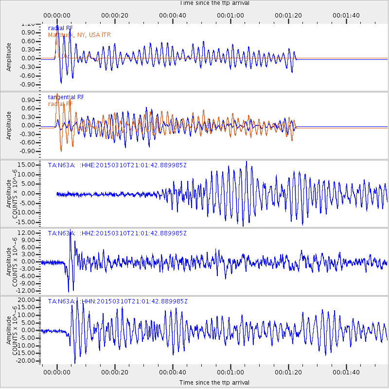
N63A Mattituck, NY, USA - Earthquake Result Viewer
*The percent match for this event was below the threshold and hence no stack was calculated.
| Earthquake location: |
Northern Colombia |
| Earthquake latitude/longitude: |
6.8/-73.0 |
| Earthquake time(UTC): |
2015/03/10 (069) 20:55:43 GMT |
| Earthquake Depth: |
147 km |
| Earthquake Magnitude: |
6.2 MWB |
| Earthquake Catalog/Contributor: |
NEIC PDE/NEIC COMCAT |
|
| Network: |
TA USArray Transportable Network (new EarthScope stations) |
| Station: |
N63A Mattituck, NY, USA |
| Lat/Lon: |
40.99 N/72.52 W |
| Elevation: |
8.0 m |
|
| Distance: |
34.0 deg |
| Az: |
0.664 deg |
| Baz: |
180.871 deg |
| Ray Param: |
$rayparam |
*The percent match for this event was below the threshold and hence was not used in the summary stack. |
|
| Radial Match: |
76.95274 % |
| Radial Bump: |
360 |
| Transverse Match: |
74.44096 % |
| Transverse Bump: |
320 |
| SOD ConfigId: |
7019011 |
| Insert Time: |
2019-04-17 07:02:32.193 +0000 |
| GWidth: |
2.5 |
| Max Bumps: |
400 |
| Tol: |
0.001 |
|
Signal To Noise
| Channel | StoN | STA | LTA |
| TA:N63A: :HHZ:20150310T21:01:42.889985Z | 10.607741 | 4.1734856E-6 | 3.934377E-7 |
| TA:N63A: :HHN:20150310T21:01:42.889985Z | 4.648389 | 2.315498E-6 | 4.9812917E-7 |
| TA:N63A: :HHE:20150310T21:01:42.889985Z | 1.3549067 | 6.2960567E-7 | 4.6468563E-7 |
| Arrivals |
| Ps | |
| PpPs | |
| PsPs/PpSs | |


