You are here: Home > Network List > TA - USArray Transportable Network (new EarthScope stations) Stations List
> Station M66A Nantucket, MA, USA > Earthquake Result Viewer
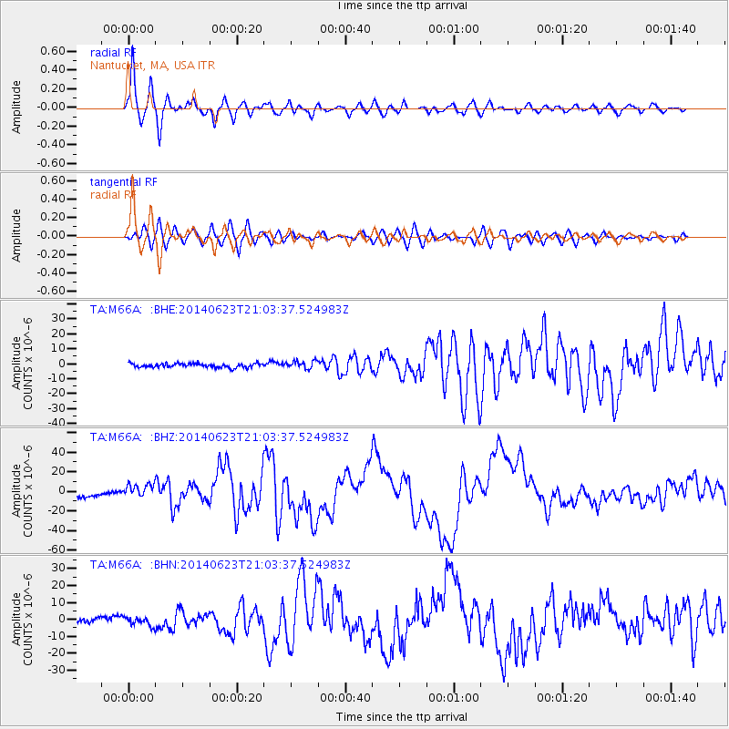
M66A Nantucket, MA, USA - Earthquake Result Viewer

| Earthquake location: |
Rat Islands, Aleutian Islands |
| Earthquake latitude/longitude: |
51.8/178.8 |
| Earthquake time(UTC): |
2014/06/23 (174) 20:53:09 GMT |
| Earthquake Depth: |
108 km |
| Earthquake Magnitude: |
7.9 MWW, 7.1 MI, 7.9 MWC |
| Earthquake Catalog/Contributor: |
NEIC PDE/NEIC COMCAT |
|
| Network: |
TA USArray Transportable Network (new EarthScope stations) |
| Station: |
M66A Nantucket, MA, USA |
| Lat/Lon: |
41.26 N/70.14 W |
| Elevation: |
9.0 m |
|
| Distance: |
69.7 deg |
| Az: |
48.57 deg |
| Baz: |
321.86 deg |
| Ray Param: |
0.0551738 |
| Estimated Moho Depth: |
26.75 km |
| Estimated Crust Vp/Vs: |
1.97 |
| Assumed Crust Vp: |
6.472 km/s |
| Estimated Crust Vs: |
3.289 km/s |
| Estimated Crust Poisson's Ratio: |
0.33 |
|
| Radial Match: |
95.24303 % |
| Radial Bump: |
400 |
| Transverse Match: |
87.458626 % |
| Transverse Bump: |
400 |
| SOD ConfigId: |
739768 |
| Insert Time: |
2014-07-07 21:54:05.159 +0000 |
| GWidth: |
2.5 |
| Max Bumps: |
400 |
| Tol: |
0.001 |
|
Signal To Noise
| Channel | StoN | STA | LTA |
| TA:M66A: :BHZ:20140623T21:03:37.524983Z | 2.705581 | 6.9165503E-6 | 2.5564011E-6 |
| TA:M66A: :BHN:20140623T21:03:37.524983Z | 1.6391555 | 2.5704435E-6 | 1.5681511E-6 |
| TA:M66A: :BHE:20140623T21:03:37.524983Z | 2.010484 | 2.666218E-6 | 1.3261573E-6 |
| Arrivals |
| Ps | 4.1 SECOND |
| PpPs | 12 SECOND |
| PsPs/PpSs | 16 SECOND |


