You are here: Home > Network List > TA - USArray Transportable Network (new EarthScope stations) Stations List
> Station N63A Mattituck, NY, USA > Earthquake Result Viewer
N63A Mattituck, NY, USA - Earthquake Result Viewer
| Earthquake location: |
Rat Islands, Aleutian Islands |
| Earthquake latitude/longitude: |
51.8/178.8 |
| Earthquake time(UTC): |
2014/06/23 (174) 20:53:09 GMT |
| Earthquake Depth: |
108 km |
| Earthquake Magnitude: |
7.9 MWW, 7.1 MI, 7.9 MWC |
| Earthquake Catalog/Contributor: |
NEIC PDE/NEIC COMCAT |
|
| Network: |
TA USArray Transportable Network (new EarthScope stations) |
| Station: |
N63A Mattituck, NY, USA |
| Lat/Lon: |
40.99 N/72.52 W |
| Elevation: |
8.0 m |
|
| Distance: |
68.8 deg |
| Az: |
50.256 deg |
| Baz: |
320.894 deg |
| Ray Param: |
0.055777032 |
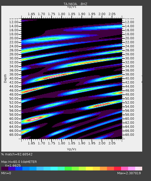
| Estimated Moho Depth: |
60.0 km |
| Estimated Crust Vp/Vs: |
1.66 |
| Assumed Crust Vp: |
6.472 km/s |
| Estimated Crust Vs: |
3.893 km/s |
| Estimated Crust Poisson's Ratio: |
0.22 |
|
| Radial Match: |
92.68542 % |
| Radial Bump: |
400 |
| Transverse Match: |
85.220085 % |
| Transverse Bump: |
400 |
| SOD ConfigId: |
739768 |
| Insert Time: |
2014-07-07 21:55:06.092 +0000 |
| GWidth: |
2.5 |
| Max Bumps: |
400 |
| Tol: |
0.001 |
|
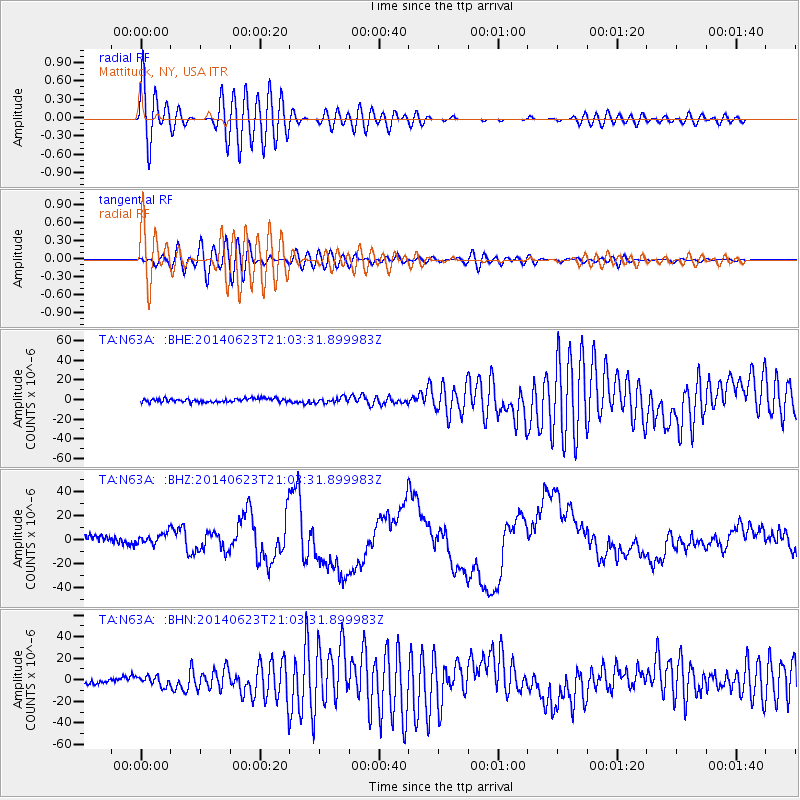
Signal To Noise
| Channel | StoN | STA | LTA |
| TA:N63A: :BHZ:20140623T21:03:31.899983Z | 1.3925952 | 4.510644E-6 | 3.2390203E-6 |
| TA:N63A: :BHN:20140623T21:03:31.899983Z | 1.899439 | 4.4363355E-6 | 2.335603E-6 |
| TA:N63A: :BHE:20140623T21:03:31.899983Z | 1.4675187 | 2.6866257E-6 | 1.8307268E-6 |
| Arrivals |
| Ps | 6.4 SECOND |
| PpPs | 24 SECOND |
| PsPs/PpSs | 30 SECOND |


