You are here: Home > Network List > CI - Caltech Regional Seismic Network Stations List
> Station GPO Geothermal Program Office, California, USA > Earthquake Result Viewer
GPO Geothermal Program Office, California, USA - Earthquake Result Viewer
| Earthquake location: |
Near East Coast Of Kamchatka |
| Earthquake latitude/longitude: |
54.7/162.9 |
| Earthquake time(UTC): |
1997/12/07 (341) 17:56:18 GMT |
| Earthquake Depth: |
33 km |
| Earthquake Magnitude: |
5.6 MB, 6.0 MS, 6.3 UNKNOWN, 6.1 MW |
| Earthquake Catalog/Contributor: |
WHDF/NEIC |
|
| Network: |
CI Caltech Regional Seismic Network |
| Station: |
GPO Geothermal Program Office, California, USA |
| Lat/Lon: |
35.65 N/117.66 W |
| Elevation: |
735 m |
|
| Distance: |
56.0 deg |
| Az: |
74.913 deg |
| Baz: |
316.463 deg |
| Ray Param: |
0.06435212 |
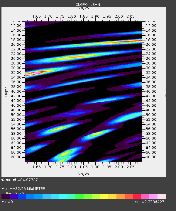
| Estimated Moho Depth: |
32.25 km |
| Estimated Crust Vp/Vs: |
1.63 |
| Assumed Crust Vp: |
6.276 km/s |
| Estimated Crust Vs: |
3.856 km/s |
| Estimated Crust Poisson's Ratio: |
0.20 |
|
| Radial Match: |
84.97737 % |
| Radial Bump: |
400 |
| Transverse Match: |
76.80062 % |
| Transverse Bump: |
400 |
| SOD ConfigId: |
3770 |
| Insert Time: |
2010-02-25 21:10:11.361 +0000 |
| GWidth: |
2.5 |
| Max Bumps: |
400 |
| Tol: |
0.001 |
|
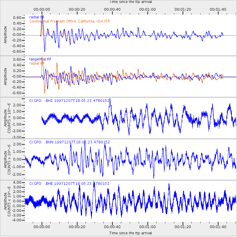
Signal To Noise
| Channel | StoN | STA | LTA |
| CI:GPO: :BHN:19971207T18:05:23.478015Z | 1.4057995 | 4.2870522E-7 | 3.0495474E-7 |
| CI:GPO: :BHE:19971207T18:05:23.478015Z | 0.97412485 | 6.3699105E-7 | 6.539111E-7 |
| CI:GPO: :BHZ:19971207T18:05:23.478015Z | 1.6440238 | 6.592715E-7 | 4.0101094E-7 |
| Arrivals |
| Ps | 3.4 SECOND |
| PpPs | 13 SECOND |
| PsPs/PpSs | 16 SECOND |


