
Station CI GPO - Geothermal Program Office, California, USA
Network: CI - Caltech Regional Seismic Network
Nearby stations (2 deg radius)
| Station | Name | (Lat, Lon) | Start / End | Elevation |
| GPO | Geothermal Program Office, California, USA | (35.65, -117.66) | 1996-01-12 / 2499-01-01 | 735 m |
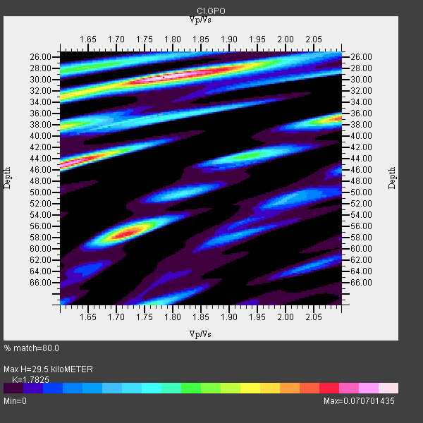
| Crust2 Type: | M5,extended crust, 0.5 km seds. |
| Thickness Estimate: | 30 km |
| Thickness StdDev: | 9.7 km |
| Vp/Vs Estimate: | 1.78 |
| Vp/Vs StdDev: | 0.13 |
| Vs Estimate: | 3.521 km/s |
| Poisson's Ratio: | 0.27 |
| Peak Value: | 0.07 |
| Assumed Vp: | 6.276 km/s |
| Ps Weight: | 0.33333334 |
| PpPs Weight: | 0.33333334 |
| PsPs Weight: | 0.33333328 |
| Residual Complexity: | 0.753 |
| Nearby stations H: | 30 km +- 0.7 km |
| (2.0 deg) Vp/Vs: | 1.80 +- 0.03 |
0 with match > 90% ( 0.0 %) and 6 with match > 80% ( 30.0 %) out of 20.
Download stack as xyz text file.
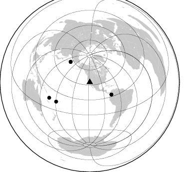
Azimuth Distribution of Events:
Prior Results for this Station
| Study | Thickness | Vp/Vs | Vp | Vs | Poissons Ratio | Extra |
| EARS | 30 km | 1.78 | 6.276 km/s | 3.521 km/s | 0.27 | |
| Crust2.0 | 31 km | 1.78 | 6.276 km/s | 3.529 km/s | 0.27 | M5,extended crust, 0.5 km seds. |
| Zhu S. Cal. | 30 km | 1.85 | 6.3 km/s | 3.405 km/s | 0.29 | |
| Global Maxima | 30 km | 1.78 | 6.276 km/s | 3.521 km/s | 0.27 | amp=0.070701435 |
| Local Maxima 1 | 45 km | 1.62 | 6.276 km/s | 3.886 km/s | 0.19 | amp=0.066200085 |
| Local Maxima 2 | 58 km | 1.71 | 6.276 km/s | 3.665 km/s | 0.24 | amp=0.06041327 |
| Local Maxima 3 | 37 km | 2.10 | 6.276 km/s | 2.992 km/s | 0.35 | amp=0.054775767 |
| Local Maxima 4 | 38 km | 1.60 | 6.276 km/s | 3.922 km/s | 0.18 | amp=0.044837173 |
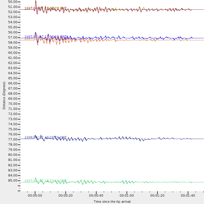
| Predicted Arrivals for vertical incidence (zero ray parameter) | |
| Ps | 3.68 SECOND |
| PpPs | 13.08 SECOND |
| PsPs/PpSs | 16.76 SECOND |
Events Processed for this Station
Download zip of receiver functions as SAC
Plot maxima for each earthquake.
Events Used in the Stack
(6 events)| Radial Match | Distance | Baz | FERegion | Time | Lat/Lon | Depth | Magnitude |
| 89.73311 | 56.4 deg | 316.831 deg | Near East Coast Of Kamchatka | 1997/12/05 11:26:54 GMT | (54.8, 162.0) | 33 km | 6.3 MB, 7.6 MS, 7.9 UNKNOWN, 7.3 ME |
| 89.23797 | 86.9 deg | 249.063 deg | Vanuatu Islands | 1997/11/15 18:59:24 GMT | (-15.1, 167.4) | 123 km | 6.4 MB, 7.0 UNKNOWN, 6.8 ME |
| 89.05002 | 50.0 deg | 119.463 deg | Colombia | 1997/09/02 12:13:22 GMT | (3.8, -75.7) | 199 km | 6.5 MB, 6.8 UNKNOWN, 6.4 ME |
| 84.97737 | 56.0 deg | 316.463 deg | Near East Coast Of Kamchatka | 1997/12/07 17:56:18 GMT | (54.7, 162.9) | 33 km | 5.6 MB, 6.0 MS, 6.3 UNKNOWN, 6.1 MW |
| 82.06157 | 77.6 deg | 240.186 deg | Fiji Islands Region | 1998/01/12 16:36:20 GMT | (-15.8, -179.4) | 23 km | 5.8 MB, 6.7 MS, 6.9 UNKNOWN, 6.7 MW |
| 80.2827 | 49.9 deg | 119.424 deg | Colombia | 1997/12/11 07:56:28 GMT | (3.9, -75.8) | 178 km | 6.0 MB, 6.4 UNKNOWN, 6.3 MW |
Losers
(14 events)| Radial Match | Distance | Baz | FERegion | Time | Lat/Lon | Depth | Magnitude | Reason |
| 80.2581 | 87.3 deg | 228.78 deg | Kermadec Islands, New Zealand | 1997/10/27 09:32:59 GMT | (-30.8, -178.5) | 33 km | 5.5 MB, 5.4 MS | |
| 72.74981 | 67.4 deg | 127.569 deg | Peru-Bolivia Border Region | 1997/11/28 22:53:41 GMT | (-13.7, -68.8) | 586 km | 6.4 MB, 6.6 UNKNOWN, 6.6 MW | |
| 68.0976 | 57.0 deg | 315.851 deg | Off East Coast Of Kamchatka | 1997/12/05 11:35:19 GMT | (53.9, 161.6) | 33 km | 5.7 MB | |
| 65.9656 | 79.6 deg | 301.814 deg | Southeast Of Honshu, Japan | 1997/09/30 06:27:24 GMT | (32.0, 141.9) | 10 km | 5.5 MB, 6.5 MS, 6.1 UNKNOWN, 6.0 MW | |
| 64.99877 | 77.5 deg | 240.2 deg | Fiji Islands Region | 1998/01/14 19:56:12 GMT | (-15.8, -179.3) | 33 km | 5.3 MB, 5.7 MS | |
| 62.551517 | 96.8 deg | 268.128 deg | Eastern New Guinea Reg., P.N.G. | 1997/12/22 02:05:50 GMT | (-5.5, 147.9) | 179 km | 6.3 MB, 6.7 MS, 7.1 UNKNOWN, 7.0 ME | |
| 58.27353 | 31.3 deg | 126.767 deg | Near Coast Of Chiapas, Mexico | 1997/12/25 22:16:19 GMT | (14.1, -92.3) | 10 km | 5.4 MB, 5.3 MS, 5.8 UNKNOWN, 5.5 MD | |
| 56.998795 | 86.5 deg | 233.755 deg | South Of Fiji Islands | 1997/09/04 04:23:37 GMT | (-26.6, 178.3) | 625 km | 6.3 MB, 6.8 UNKNOWN, 6.5 ME | |
| 48.8751 | 79.1 deg | 140.659 deg | Near Coast Of Central Chile | 1997/11/03 20:12:52 GMT | (-30.8, -71.3) | 45 km | 5.6 MB, 5.2 MD | |
| 44.878975 | 85.6 deg | 229.496 deg | Kermadec Islands, New Zealand | 1997/11/18 15:41:29 GMT | (-29.1, -177.7) | 52 km | 5.7 MB, 5.5 MS | |
| 44.163616 | 81.1 deg | 236.247 deg | Fiji Islands Region | 1997/11/04 10:40:43 GMT | (-21.0, -179.2) | 621 km | 5.7 UNKNOWN, 5.1 MB | |
| 35.84039 | 72.1 deg | 308.976 deg | Hokkaido, Japan Region | 1997/10/08 21:20:59 GMT | (41.9, 144.8) | 33 km | 5.5 MB, 5.6 MS, 5.9 UNKNOWN, 5.9 MW | |
| 30.404078 | 74.3 deg | 237.886 deg | Tonga Islands | 1997/08/04 18:53:58 GMT | (-15.2, -175.3) | 33 km | 5.5 MB, 6.0 MS, 6.1 UNKNOWN, 6.0 MW | |
| 25.074955 | 95.5 deg | 266.528 deg | New Britain Region, P.N.G. | 1997/12/15 10:28:06 GMT | (-6.0, 149.9) | 33 km | 5.8 MS, 5.3 MB, 5.9 UNKNOWN, 5.9 MW |
