You are here: Home > Network List > CI - Caltech Regional Seismic Network Stations List
> Station GPO Geothermal Program Office, California, USA > Earthquake Result Viewer
GPO Geothermal Program Office, California, USA - Earthquake Result Viewer
| Earthquake location: |
Near East Coast Of Kamchatka |
| Earthquake latitude/longitude: |
54.8/162.0 |
| Earthquake time(UTC): |
1997/12/05 (339) 11:26:54 GMT |
| Earthquake Depth: |
33 km |
| Earthquake Magnitude: |
6.3 MB, 7.6 MS, 7.9 UNKNOWN, 7.3 ME |
| Earthquake Catalog/Contributor: |
WHDF/NEIC |
|
| Network: |
CI Caltech Regional Seismic Network |
| Station: |
GPO Geothermal Program Office, California, USA |
| Lat/Lon: |
35.65 N/117.66 W |
| Elevation: |
735 m |
|
| Distance: |
56.4 deg |
| Az: |
74.428 deg |
| Baz: |
316.831 deg |
| Ray Param: |
0.0640756 |
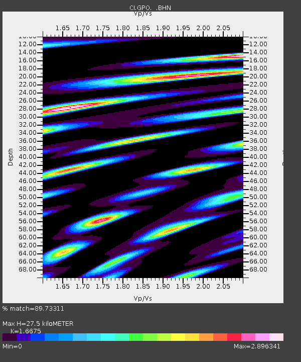
| Estimated Moho Depth: |
27.5 km |
| Estimated Crust Vp/Vs: |
1.67 |
| Assumed Crust Vp: |
6.276 km/s |
| Estimated Crust Vs: |
3.764 km/s |
| Estimated Crust Poisson's Ratio: |
0.22 |
|
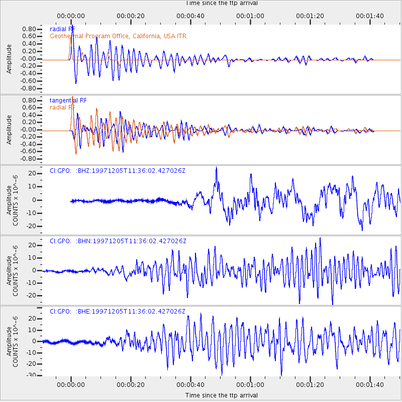
| Radial Match: |
89.73311 % |
| Radial Bump: |
400 |
| Transverse Match: |
82.3666 % |
| Transverse Bump: |
400 |
| SOD ConfigId: |
4770 |
| Insert Time: |
2010-02-25 21:10:12.710 +0000 |
| GWidth: |
2.5 |
| Max Bumps: |
400 |
| Tol: |
0.001 |
|
Signal To Noise
| Channel | StoN | STA | LTA |
| CI:GPO: :BHN:19971205T11:36:02.427026Z | 0.71090543 | 4.4605827E-7 | 6.274509E-7 |
| CI:GPO: :BHE:19971205T11:36:02.427026Z | 1.2382022 | 8.9784396E-7 | 7.25119E-7 |
| CI:GPO: :BHZ:19971205T11:36:02.427026Z | 1.9503924 | 1.1831828E-6 | 6.0663837E-7 |
| Arrivals |
| Ps | 3.1 SECOND |
| PpPs | 11 SECOND |
| PsPs/PpSs | 14 SECOND |


