You are here: Home > Network List > CI - Caltech Regional Seismic Network Stations List
> Station GPO Geothermal Program Office, California, USA > Earthquake Result Viewer
GPO Geothermal Program Office, California, USA - Earthquake Result Viewer
| Earthquake location: |
Colombia |
| Earthquake latitude/longitude: |
3.9/-75.8 |
| Earthquake time(UTC): |
1997/12/11 (345) 07:56:28 GMT |
| Earthquake Depth: |
178 km |
| Earthquake Magnitude: |
6.0 MB, 6.4 UNKNOWN, 6.3 MW |
| Earthquake Catalog/Contributor: |
WHDF/NEIC |
|
| Network: |
CI Caltech Regional Seismic Network |
| Station: |
GPO Geothermal Program Office, California, USA |
| Lat/Lon: |
35.65 N/117.66 W |
| Elevation: |
735 m |
|
| Distance: |
49.9 deg |
| Az: |
314.68 deg |
| Baz: |
119.424 deg |
| Ray Param: |
0.0677796 |
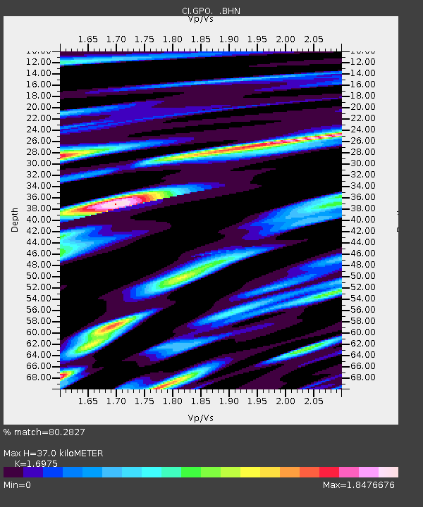
| Estimated Moho Depth: |
37.0 km |
| Estimated Crust Vp/Vs: |
1.70 |
| Assumed Crust Vp: |
6.276 km/s |
| Estimated Crust Vs: |
3.697 km/s |
| Estimated Crust Poisson's Ratio: |
0.23 |
|
| Radial Match: |
80.2827 % |
| Radial Bump: |
400 |
| Transverse Match: |
69.39458 % |
| Transverse Bump: |
400 |
| SOD ConfigId: |
4770 |
| Insert Time: |
2010-02-25 21:10:14.010 +0000 |
| GWidth: |
2.5 |
| Max Bumps: |
400 |
| Tol: |
0.001 |
|
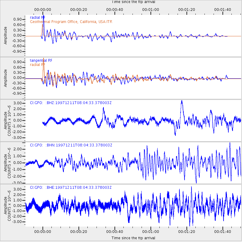
Signal To Noise
| Channel | StoN | STA | LTA |
| CI:GPO: :BHN:19971211T08:04:33.378003Z | 0.63804805 | 2.8174733E-7 | 4.4157696E-7 |
| CI:GPO: :BHE:19971211T08:04:33.378003Z | 1.1531357 | 6.8795305E-7 | 5.9659334E-7 |
| CI:GPO: :BHZ:19971211T08:04:33.378003Z | 2.8033597 | 9.310111E-7 | 3.3210546E-7 |
| Arrivals |
| Ps | 4.4 SECOND |
| PpPs | 15 SECOND |
| PsPs/PpSs | 19 SECOND |


