You are here: Home > Network List > CI - Caltech Regional Seismic Network Stations List
> Station GPO Geothermal Program Office, California, USA > Earthquake Result Viewer
GPO Geothermal Program Office, California, USA - Earthquake Result Viewer
| Earthquake location: |
Vanuatu Islands |
| Earthquake latitude/longitude: |
-15.1/167.4 |
| Earthquake time(UTC): |
1997/11/15 (319) 18:59:24 GMT |
| Earthquake Depth: |
123 km |
| Earthquake Magnitude: |
6.4 MB, 7.0 UNKNOWN, 6.8 ME |
| Earthquake Catalog/Contributor: |
WHDF/NEIC |
|
| Network: |
CI Caltech Regional Seismic Network |
| Station: |
GPO Geothermal Program Office, California, USA |
| Lat/Lon: |
35.65 N/117.66 W |
| Elevation: |
735 m |
|
| Distance: |
86.9 deg |
| Az: |
51.97 deg |
| Baz: |
249.063 deg |
| Ray Param: |
0.04341762 |
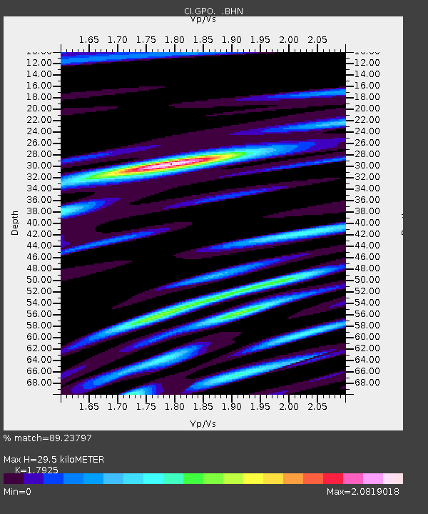
| Estimated Moho Depth: |
29.5 km |
| Estimated Crust Vp/Vs: |
1.79 |
| Assumed Crust Vp: |
6.276 km/s |
| Estimated Crust Vs: |
3.501 km/s |
| Estimated Crust Poisson's Ratio: |
0.27 |
|
| Radial Match: |
89.23797 % |
| Radial Bump: |
400 |
| Transverse Match: |
77.86167 % |
| Transverse Bump: |
400 |
| SOD ConfigId: |
3787 |
| Insert Time: |
2010-02-25 21:10:16.940 +0000 |
| GWidth: |
2.5 |
| Max Bumps: |
400 |
| Tol: |
0.001 |
|
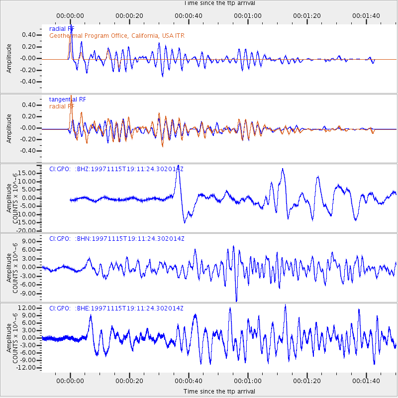
Signal To Noise
| Channel | StoN | STA | LTA |
| CI:GPO: :BHN:19971115T19:11:24.302014Z | 1.0064586 | 5.059597E-7 | 5.027128E-7 |
| CI:GPO: :BHE:19971115T19:11:24.302014Z | 0.95935994 | 7.819812E-7 | 8.151072E-7 |
| CI:GPO: :BHZ:19971115T19:11:24.302014Z | 1.3885313 | 9.921E-7 | 7.144959E-7 |
| Arrivals |
| Ps | 3.8 SECOND |
| PpPs | 13 SECOND |
| PsPs/PpSs | 17 SECOND |


