You are here: Home > Network List > CI - Caltech Regional Seismic Network Stations List
> Station GPO Geothermal Program Office, California, USA > Earthquake Result Viewer
GPO Geothermal Program Office, California, USA - Earthquake Result Viewer
| Earthquake location: |
Fiji Islands Region |
| Earthquake latitude/longitude: |
-15.8/-179.4 |
| Earthquake time(UTC): |
1998/01/12 (012) 16:36:20 GMT |
| Earthquake Depth: |
23 km |
| Earthquake Magnitude: |
5.8 MB, 6.7 MS, 6.9 UNKNOWN, 6.7 MW |
| Earthquake Catalog/Contributor: |
WHDF/NEIC |
|
| Network: |
CI Caltech Regional Seismic Network |
| Station: |
GPO Geothermal Program Office, California, USA |
| Lat/Lon: |
35.65 N/117.66 W |
| Elevation: |
735 m |
|
| Distance: |
77.6 deg |
| Az: |
47.24 deg |
| Baz: |
240.186 deg |
| Ray Param: |
0.05015725 |
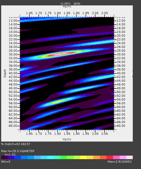
| Estimated Moho Depth: |
29.5 km |
| Estimated Crust Vp/Vs: |
1.82 |
| Assumed Crust Vp: |
6.276 km/s |
| Estimated Crust Vs: |
3.448 km/s |
| Estimated Crust Poisson's Ratio: |
0.28 |
|
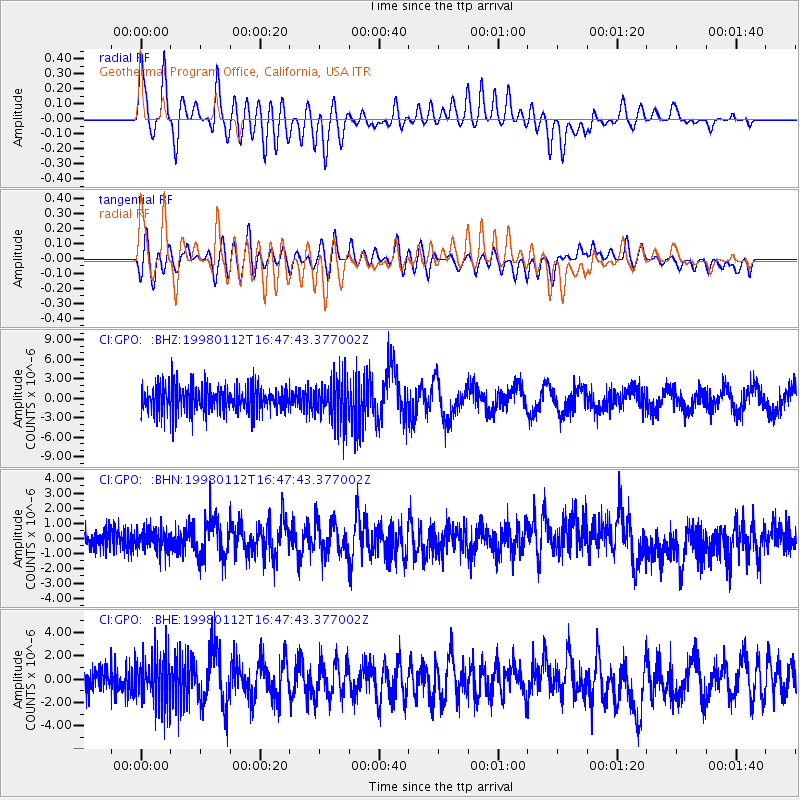
| Radial Match: |
82.06157 % |
| Radial Bump: |
400 |
| Transverse Match: |
66.13545 % |
| Transverse Bump: |
400 |
| SOD ConfigId: |
4770 |
| Insert Time: |
2010-02-25 21:10:18.424 +0000 |
| GWidth: |
2.5 |
| Max Bumps: |
400 |
| Tol: |
0.001 |
|
Signal To Noise
| Channel | StoN | STA | LTA |
| CI:GPO: :BHN:19980112T16:47:43.377002Z | 1.2023519 | 7.3470346E-7 | 6.1105527E-7 |
| CI:GPO: :BHE:19980112T16:47:43.377002Z | 1.5922647 | 2.0613554E-6 | 1.294606E-6 |
| CI:GPO: :BHZ:19980112T16:47:43.377002Z | 1.5858493 | 3.2453343E-6 | 2.046433E-6 |
| Arrivals |
| Ps | 4.0 SECOND |
| PpPs | 13 SECOND |
| PsPs/PpSs | 17 SECOND |


