You are here: Home > Network List > CI - Caltech Regional Seismic Network Stations List
> Station GPO Geothermal Program Office, California, USA > Earthquake Result Viewer
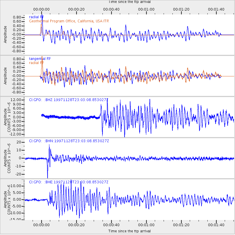
GPO Geothermal Program Office, California, USA - Earthquake Result Viewer
*The percent match for this event was below the threshold and hence no stack was calculated.
| Earthquake location: |
Peru-Bolivia Border Region |
| Earthquake latitude/longitude: |
-13.7/-68.8 |
| Earthquake time(UTC): |
1997/11/28 (332) 22:53:41 GMT |
| Earthquake Depth: |
586 km |
| Earthquake Magnitude: |
6.4 MB, 6.6 UNKNOWN, 6.6 MW |
| Earthquake Catalog/Contributor: |
WHDF/NEIC |
|
| Network: |
CI Caltech Regional Seismic Network |
| Station: |
GPO Geothermal Program Office, California, USA |
| Lat/Lon: |
35.65 N/117.66 W |
| Elevation: |
735 m |
|
| Distance: |
67.4 deg |
| Az: |
318.37 deg |
| Baz: |
127.569 deg |
| Ray Param: |
$rayparam |
*The percent match for this event was below the threshold and hence was not used in the summary stack. |
|
| Radial Match: |
72.74981 % |
| Radial Bump: |
400 |
| Transverse Match: |
75.561035 % |
| Transverse Bump: |
400 |
| SOD ConfigId: |
4480 |
| Insert Time: |
2010-02-25 21:10:37.575 +0000 |
| GWidth: |
2.5 |
| Max Bumps: |
400 |
| Tol: |
0.001 |
|
Signal To Noise
| Channel | StoN | STA | LTA |
| CI:GPO: :BHN:19971128T23:03:08.853027Z | 12.245387 | 6.3753464E-6 | 5.206325E-7 |
| CI:GPO: :BHE:19971128T23:03:08.853027Z | 4.515677 | 1.507729E-6 | 3.3388773E-7 |
| CI:GPO: :BHZ:19971128T23:03:08.853027Z | 3.978716 | 2.879007E-6 | 7.2360206E-7 |
| Arrivals |
| Ps | |
| PpPs | |
| PsPs/PpSs | |


