You are here: Home > Network List > IC - New China Digital Seismograph Network Stations List
> Station HIA Hailar, Neimenggu Autonomous Region, China > Earthquake Result Viewer
HIA Hailar, Neimenggu Autonomous Region, China - Earthquake Result Viewer
| Earthquake location: |
New Britain Region, P.N.G. |
| Earthquake latitude/longitude: |
-6.2/152.8 |
| Earthquake time(UTC): |
2014/07/04 (185) 15:00:26 GMT |
| Earthquake Depth: |
10 km |
| Earthquake Magnitude: |
6.6 MWP, 6.7 MI |
| Earthquake Catalog/Contributor: |
NEIC PDE/NEIC COMCAT |
|
| Network: |
IC New China Digital Seismograph Network |
| Station: |
HIA Hailar, Neimenggu Autonomous Region, China |
| Lat/Lon: |
49.27 N/119.74 E |
| Elevation: |
620 m |
|
| Distance: |
62.3 deg |
| Az: |
336.19 deg |
| Baz: |
142.21 deg |
| Ray Param: |
0.060304403 |
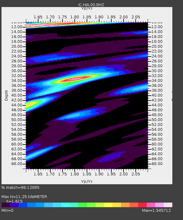
| Estimated Moho Depth: |
11.25 km |
| Estimated Crust Vp/Vs: |
1.62 |
| Assumed Crust Vp: |
6.577 km/s |
| Estimated Crust Vs: |
4.072 km/s |
| Estimated Crust Poisson's Ratio: |
0.19 |
|
| Radial Match: |
98.12895 % |
| Radial Bump: |
279 |
| Transverse Match: |
92.264725 % |
| Transverse Bump: |
400 |
| SOD ConfigId: |
751272 |
| Insert Time: |
2014-07-18 15:24:25.781 +0000 |
| GWidth: |
2.5 |
| Max Bumps: |
400 |
| Tol: |
0.001 |
|

Signal To Noise
| Channel | StoN | STA | LTA |
| IC:HIA:00:BHZ:20140704T15:10:17.669014Z | 70.58455 | 3.2318521E-6 | 4.5786962E-8 |
| IC:HIA:00:BH1:20140704T15:10:17.669014Z | 30.384628 | 1.0525459E-6 | 3.464074E-8 |
| IC:HIA:00:BH2:20140704T15:10:17.669014Z | 22.88189 | 7.6377574E-7 | 3.3379052E-8 |
| Arrivals |
| Ps | 1.1 SECOND |
| PpPs | 4.2 SECOND |
| PsPs/PpSs | 5.4 SECOND |


