You are here: Home > Network List > TA - USArray Transportable Network (new EarthScope stations) Stations List
> Station M66A Nantucket, MA, USA > Earthquake Result Viewer
M66A Nantucket, MA, USA - Earthquake Result Viewer
| Earthquake location: |
Near Coast Of Chiapas, Mexico |
| Earthquake latitude/longitude: |
14.7/-92.4 |
| Earthquake time(UTC): |
2014/07/07 (188) 11:23:55 GMT |
| Earthquake Depth: |
60 km |
| Earthquake Magnitude: |
6.9 MWW, 6.9 MWC, 7.1 MI |
| Earthquake Catalog/Contributor: |
NEIC PDE/NEIC COMCAT |
|
| Network: |
TA USArray Transportable Network (new EarthScope stations) |
| Station: |
M66A Nantucket, MA, USA |
| Lat/Lon: |
41.26 N/70.14 W |
| Elevation: |
9.0 m |
|
| Distance: |
32.7 deg |
| Az: |
31.895 deg |
| Baz: |
222.69 deg |
| Ray Param: |
0.07838506 |
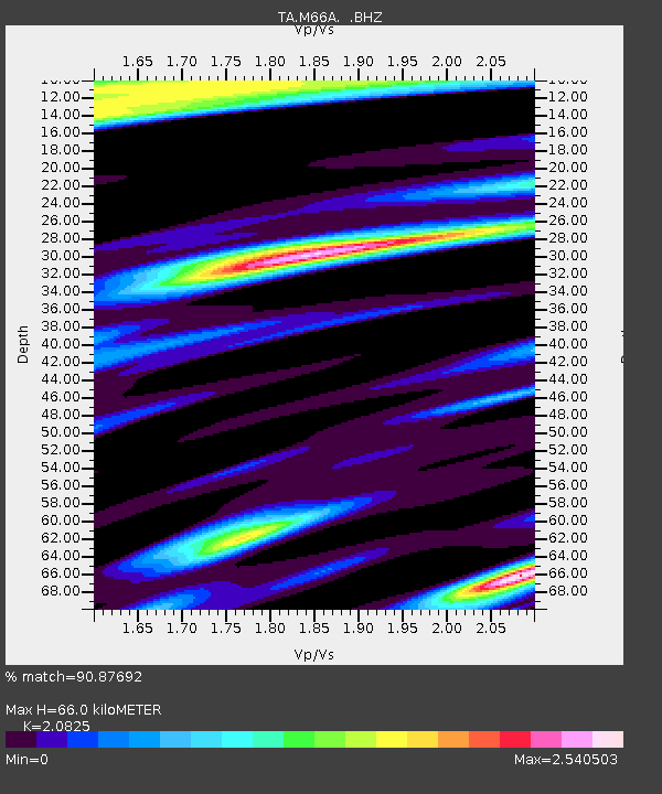
| Estimated Moho Depth: |
66.0 km |
| Estimated Crust Vp/Vs: |
2.08 |
| Assumed Crust Vp: |
6.472 km/s |
| Estimated Crust Vs: |
3.108 km/s |
| Estimated Crust Poisson's Ratio: |
0.35 |
|
| Radial Match: |
90.87692 % |
| Radial Bump: |
400 |
| Transverse Match: |
63.6475 % |
| Transverse Bump: |
400 |
| SOD ConfigId: |
751272 |
| Insert Time: |
2014-07-21 12:16:52.696 +0000 |
| GWidth: |
2.5 |
| Max Bumps: |
400 |
| Tol: |
0.001 |
|
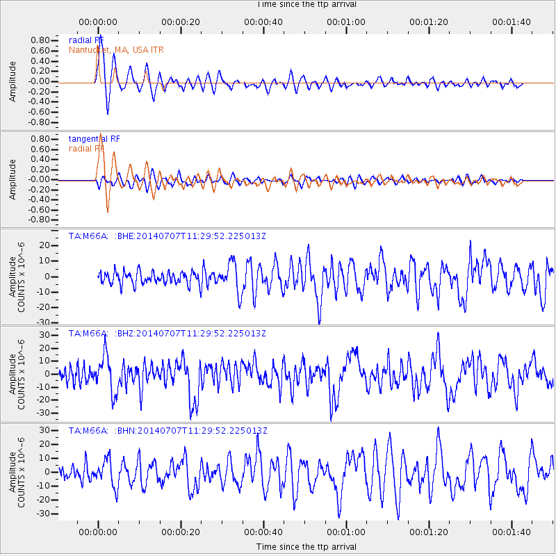
Signal To Noise
| Channel | StoN | STA | LTA |
| TA:M66A: :BHZ:20140707T11:29:52.225013Z | 3.12813 | 1.4825599E-5 | 4.7394446E-6 |
| TA:M66A: :BHN:20140707T11:29:52.225013Z | 2.8934894 | 9.961953E-6 | 3.4428858E-6 |
| TA:M66A: :BHE:20140707T11:29:52.225013Z | 2.573314 | 9.908592E-6 | 3.850518E-6 |
| Arrivals |
| Ps | 12 SECOND |
| PpPs | 29 SECOND |
| PsPs/PpSs | 41 SECOND |


