You are here: Home > Network List > II - Global Seismograph Network (GSN - IRIS/IDA) Stations List
> Station KWAJ Kwajalein Atoll, Pacific Ocean > Earthquake Result Viewer
KWAJ Kwajalein Atoll, Pacific Ocean - Earthquake Result Viewer
| Earthquake location: |
Central Alaska |
| Earthquake latitude/longitude: |
63.5/-147.4 |
| Earthquake time(UTC): |
2002/11/03 (307) 22:12:41 GMT |
| Earthquake Depth: |
4.9 km |
| Earthquake Magnitude: |
7.0 MB, 8.5 MS, 7.9 MW |
| Earthquake Catalog/Contributor: |
WHDF/NEIC |
|
| Network: |
II Global Seismograph Network (GSN - IRIS/IDA) |
| Station: |
KWAJ Kwajalein Atoll, Pacific Ocean |
| Lat/Lon: |
8.80 N/167.61 E |
| Elevation: |
0.0 m |
|
| Distance: |
63.3 deg |
| Az: |
231.409 deg |
| Baz: |
20.766 deg |
| Ray Param: |
0.059686176 |
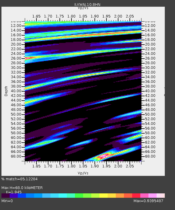
| Estimated Moho Depth: |
68.0 km |
| Estimated Crust Vp/Vs: |
1.95 |
| Assumed Crust Vp: |
4.802 km/s |
| Estimated Crust Vs: |
2.469 km/s |
| Estimated Crust Poisson's Ratio: |
0.32 |
|
| Radial Match: |
85.12284 % |
| Radial Bump: |
400 |
| Transverse Match: |
80.80535 % |
| Transverse Bump: |
400 |
| SOD ConfigId: |
4714 |
| Insert Time: |
2010-03-02 00:05:36.416 +0000 |
| GWidth: |
2.5 |
| Max Bumps: |
400 |
| Tol: |
0.001 |
|

Signal To Noise
| Channel | StoN | STA | LTA |
| II:KWAJ:10:BHN:20021103T22:22:39.489014Z | 1.4361882 | 4.2892702E-6 | 2.9865655E-6 |
| II:KWAJ:10:BHE:20021103T22:22:39.489014Z | 0.77395236 | 1.7570366E-6 | 2.2702127E-6 |
| II:KWAJ:10:BHZ:20021103T22:22:39.489014Z | 5.1349626 | 8.190165E-6 | 1.5949806E-6 |
| Arrivals |
| Ps | 14 SECOND |
| PpPs | 41 SECOND |
| PsPs/PpSs | 54 SECOND |


