
Station II KWAJ - Kwajalein Atoll, Pacific Ocean
Network: II - Global Seismograph Network (GSN - IRIS/IDA)
Nearby stations (2 deg radius)
| Station | Name | (Lat, Lon) | Start / End | Elevation |
| KWAJ | Kwajalein Atoll, Pacific Ocean | (8.80, 167.61) | 1999-06-22 / 2499-01-01 | 0.0 m |
| Crust2 Type: | B0,melt affected o.c. and oceanic plateaus, 0.10 km seds. |
| Thickness Estimate: | 14 km |
| Thickness StdDev: | 1.6 km |
| Vp/Vs Estimate: | 1.73 |
| Vp/Vs StdDev: | 0.08 |
| Vs Estimate: | 2.776 km/s |
| Poisson's Ratio: | 0.25 |
| Peak Value: | 0.07 |
| Assumed Vp: | 4.802 km/s |
| Ps Weight: | 0.33333334 |
| PpPs Weight: | 0.33333334 |
| PsPs Weight: | 0.33333328 |
| Residual Complexity: | 0.363 |
| Nearby stations H: | +- |
| (2.0 deg) Vp/Vs: | +- |
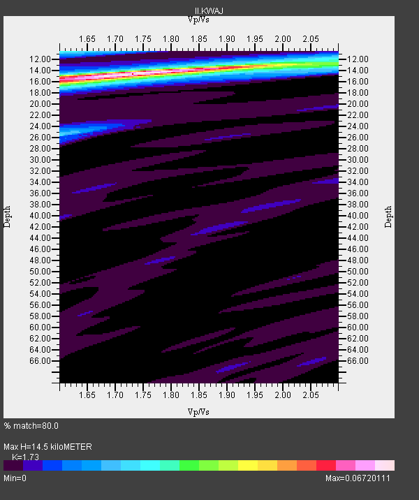
1 with match > 90% ( 12.5 %) and 7 with match > 80% ( 87.5 %) out of 8.
Download stack as xyz text file.
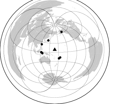
Azimuth Distribution of Events:
Prior Results for this Station
| Study | Thickness | Vp/Vs | Vp | Vs | Poissons Ratio | Extra |
| EARS | 14 km | 1.73 | 4.802 km/s | 2.776 km/s | 0.25 | |
| Crust2.0 | 16 km | 2.06 | 4.802 km/s | 2.335 km/s | 0.35 | B0,melt affected o.c. and oceanic plateaus, 0.10 km seds. |
| Global Maxima | 14 km | 1.73 | 4.802 km/s | 2.776 km/s | 0.25 | amp=0.06720111 |
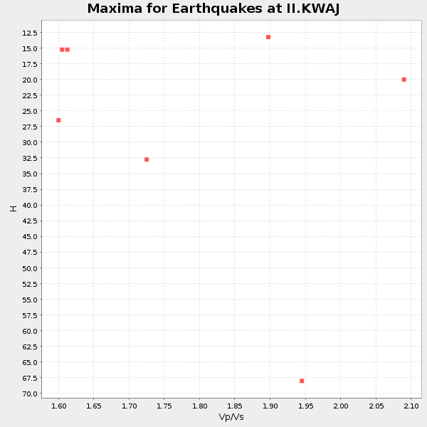
| Local Maxima 1 | 10 km | 1.60 | 4.802 km/s | 3.001 km/s | 0.18 | amp=0.025855172 |
| Local Maxima 2 | 16 km | 1.60 | 4.802 km/s | 3.001 km/s | 0.18 | amp=0.02390299 |
| Local Maxima 3 | 26 km | 1.60 | 4.802 km/s | 3.001 km/s | 0.18 | amp=0.020897934 |
| Local Maxima 4 | 12 km | 2.10 | 4.802 km/s | 2.289 km/s | 0.35 | amp=0.01843 |
| Predicted Arrivals for vertical incidence (zero ray parameter) | |
| Ps | 2.20 SECOND |
| PpPs | 8.24 SECOND |
| PsPs/PpSs | 10.45 SECOND |
Events Processed for this Station
Download zip of receiver functions as SAC
Plot maxima for each earthquake.
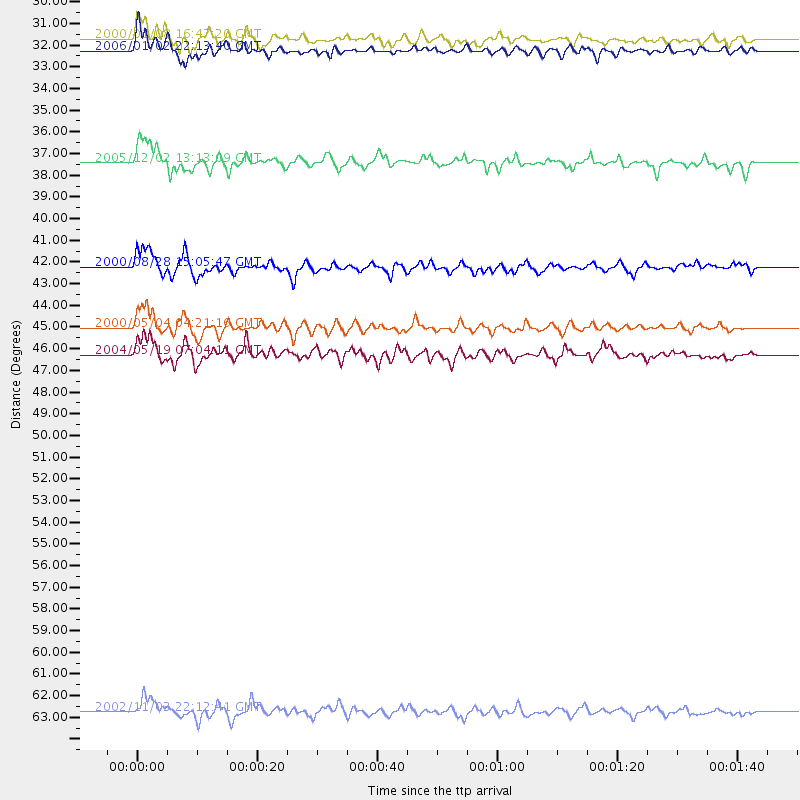
Events Used in the Stack
(7 events)| Radial Match | Distance | Baz | FERegion | Time | Lat/Lon | Depth | Magnitude |
| 91.05599 | 45.0 deg | 259.55 deg | Sulawesi, Indonesia | 2000/05/04 04:21:16 GMT | (-1.1, 123.6) | 26 km | 6.7 MB, 7.5 MS, 7.6 MW, 7.5 ME |
| 85.90329 | 42.1 deg | 253.88 deg | Banda Sea | 2000/08/28 15:05:47 GMT | (-4.1, 127.4) | 16 km | 6.5 MB, 6.8 MS, 6.8 MW, 6.7 ME |
| 85.52774 | 37.1 deg | 325.758 deg | Near East Coast Of Honshu, Japan | 2005/12/02 13:13:09 GMT | (38.1, 142.1) | 29 km | 6.1 MB, 6.3 MS, 6.5 MW, 6.4 MW |
| 85.12284 | 63.3 deg | 20.766 deg | Central Alaska | 2002/11/03 22:12:41 GMT | (63.5, -147.4) | 4.9 km | 7.0 MB, 8.5 MS, 7.9 MW |
| 84.363716 | 31.8 deg | 154.0 deg | Fiji Islands Region | 2006/01/02 22:13:40 GMT | (-19.9, -178.2) | 583 km | 6.5 MB, 7.2 MW, 7.1 MW |
| 81.217705 | 31.2 deg | 144.915 deg | Tonga Islands | 2000/01/08 16:47:20 GMT | (-16.9, -174.2) | 183 km | 6.5 MB, 6.6 MS, 7.2 MW, 7.0 ME |
| 80.040016 | 46.3 deg | 292.907 deg | Taiwan Region | 2004/05/19 07:04:11 GMT | (22.7, 121.5) | 20 km | 5.8 MB, 6.1 MS, 6.2 MW, 6.1 MW |
Losers
(1 events)| Radial Match | Distance | Baz | FERegion | Time | Lat/Lon | Depth | Magnitude | Reason |
| 59.85258 | 70.5 deg | 268.816 deg | Northern Sumatra, Indonesia | 2005/07/05 01:52:02 GMT | (1.8, 97.1) | 21 km | 6.2 MB, 6.8 MS, 6.7 MW, 6.6 MW |
