You are here: Home > Network List > II - Global Seismograph Network (GSN - IRIS/IDA) Stations List
> Station KWAJ Kwajalein Atoll, Pacific Ocean > Earthquake Result Viewer
KWAJ Kwajalein Atoll, Pacific Ocean - Earthquake Result Viewer
| Earthquake location: |
Taiwan Region |
| Earthquake latitude/longitude: |
22.7/121.5 |
| Earthquake time(UTC): |
2004/05/19 (140) 07:04:11 GMT |
| Earthquake Depth: |
20 km |
| Earthquake Magnitude: |
5.8 MB, 6.1 MS, 6.2 MW, 6.1 MW |
| Earthquake Catalog/Contributor: |
WHDF/NEIC |
|
| Network: |
II Global Seismograph Network (GSN - IRIS/IDA) |
| Station: |
KWAJ Kwajalein Atoll, Pacific Ocean |
| Lat/Lon: |
8.80 N/167.61 E |
| Elevation: |
0.0 m |
|
| Distance: |
46.3 deg |
| Az: |
99.727 deg |
| Baz: |
292.907 deg |
| Ray Param: |
0.07072029 |
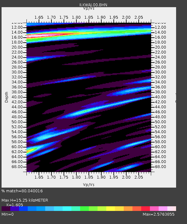
| Estimated Moho Depth: |
15.25 km |
| Estimated Crust Vp/Vs: |
1.61 |
| Assumed Crust Vp: |
4.802 km/s |
| Estimated Crust Vs: |
2.992 km/s |
| Estimated Crust Poisson's Ratio: |
0.18 |
|
| Radial Match: |
80.040016 % |
| Radial Bump: |
400 |
| Transverse Match: |
72.21404 % |
| Transverse Bump: |
400 |
| SOD ConfigId: |
2459 |
| Insert Time: |
2010-03-02 00:05:37.703 +0000 |
| GWidth: |
2.5 |
| Max Bumps: |
400 |
| Tol: |
0.001 |
|
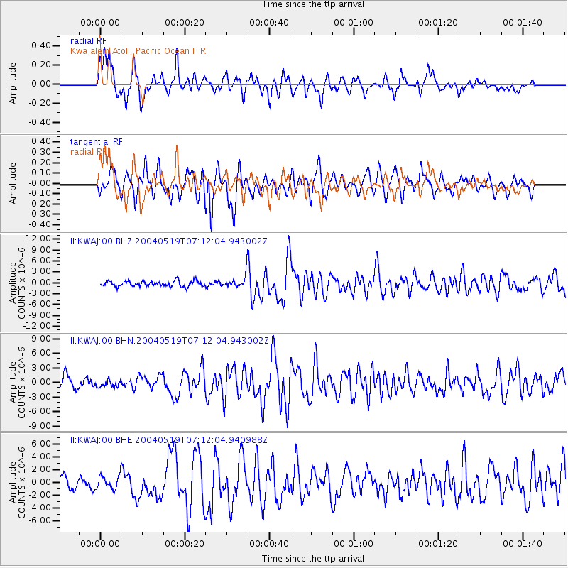
Signal To Noise
| Channel | StoN | STA | LTA |
| II:KWAJ:00:BHN:20040519T07:12:04.943002Z | 0.62751245 | 6.97377E-7 | 1.1113358E-6 |
| II:KWAJ:00:BHE:20040519T07:12:04.940988Z | 0.9576284 | 1.0544833E-6 | 1.1011402E-6 |
| II:KWAJ:00:BHZ:20040519T07:12:04.943002Z | 2.4777071 | 1.8223952E-6 | 7.3551683E-7 |
| Arrivals |
| Ps | 2.0 SECOND |
| PpPs | 8.0 SECOND |
| PsPs/PpSs | 10.0 SECOND |


