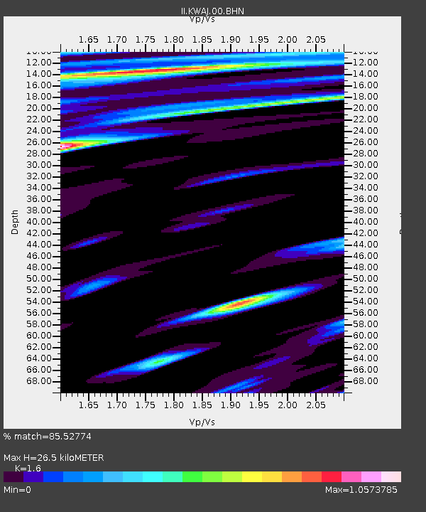
KWAJ Kwajalein Atoll, Pacific Ocean - Earthquake Result Viewer
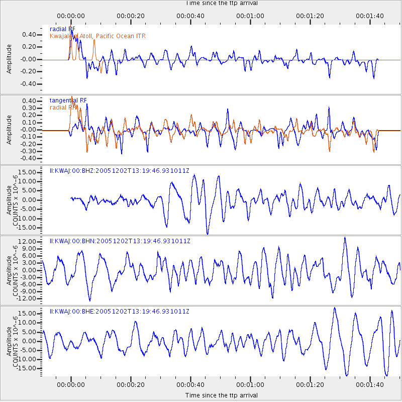
Earthquake location: Near East Coast Of Honshu, Japan
Earthquake latitude/longitude: 38.1/142.1
Earthquake time(UTC): 2005/12/02 (336) 13:13:09 GMT
Earthquake Depth: 29 km
Earthquake Magnitude: 6.1 MB, 6.3 MS, 6.5 MW, 6.4 MW
Earthquake Catalog/Contributor: WHDF/NEIC
Network: II Global Seismograph Network (GSN - IRIS/IDA)
Station: KWAJ Kwajalein Atoll, Pacific Ocean
Lat/Lon: 8.80 N/167.61 E
Elevation: 0.0 m
Distance: 37.1 deg
Az: 135.185 deg
Baz: 325.758 deg
Ray Param: 0.07625853
Estimated Moho Depth: 26.5 km
Estimated Crust Vp/Vs: 1.60
Assumed Crust Vp: 4.802 km/s
Estimated Crust Vs: 3.001 km/s
Estimated Crust Poisson's Ratio: 0.18
Radial Match: 85.52774 %
Radial Bump: 400
Transverse Match: 70.014854 %
Transverse Bump: 387
SOD ConfigId: 2422
Insert Time: 2010-03-02 00:05:38.905 +0000
GWidth: 2.5
Max Bumps: 400
Tol: 0.001

Signal To Noise

ChannelStoNSTALTA
II:KWAJ:00:BHN:20051202T13:19:46.931011Z1.71264275.307921E-63.0992576E-6
II:KWAJ:00:BHE:20051202T13:19:46.931011Z0.85743062.8399418E-63.3121535E-6
II:KWAJ:00:BHZ:20051202T13:19:46.931011Z4.71891267.6032134E-61.6112215E-6
Arrivals
Ps3.5 SECOND
PpPs14 SECOND
PsPs/PpSs17 SECOND