You are here: Home > Network List > II - Global Seismograph Network (GSN - IRIS/IDA) Stations List
> Station KWAJ Kwajalein Atoll, Pacific Ocean > Earthquake Result Viewer
KWAJ Kwajalein Atoll, Pacific Ocean - Earthquake Result Viewer
| Earthquake location: |
Fiji Islands Region |
| Earthquake latitude/longitude: |
-19.9/-178.2 |
| Earthquake time(UTC): |
2006/01/02 (002) 22:13:40 GMT |
| Earthquake Depth: |
583 km |
| Earthquake Magnitude: |
6.5 MB, 7.2 MW, 7.1 MW |
| Earthquake Catalog/Contributor: |
WHDF/NEIC |
|
| Network: |
II Global Seismograph Network (GSN - IRIS/IDA) |
| Station: |
KWAJ Kwajalein Atoll, Pacific Ocean |
| Lat/Lon: |
8.80 N/167.61 E |
| Elevation: |
0.0 m |
|
| Distance: |
31.8 deg |
| Az: |
332.58 deg |
| Baz: |
154.0 deg |
| Ray Param: |
0.0762145 |
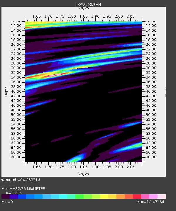
| Estimated Moho Depth: |
32.75 km |
| Estimated Crust Vp/Vs: |
1.73 |
| Assumed Crust Vp: |
4.802 km/s |
| Estimated Crust Vs: |
2.784 km/s |
| Estimated Crust Poisson's Ratio: |
0.25 |
|
| Radial Match: |
84.363716 % |
| Radial Bump: |
400 |
| Transverse Match: |
82.79163 % |
| Transverse Bump: |
400 |
| SOD ConfigId: |
2422 |
| Insert Time: |
2010-03-02 00:05:40.438 +0000 |
| GWidth: |
2.5 |
| Max Bumps: |
400 |
| Tol: |
0.001 |
|

Signal To Noise
| Channel | StoN | STA | LTA |
| II:KWAJ:00:BHN:20060102T22:18:47.910013Z | 5.595759 | 1.8445773E-5 | 3.2963846E-6 |
| II:KWAJ:00:BHE:20060102T22:18:47.910013Z | 4.1084423 | 1.1025151E-5 | 2.6835357E-6 |
| II:KWAJ:00:BHZ:20060102T22:18:47.910013Z | 23.994137 | 4.457636E-5 | 1.8578022E-6 |
| Arrivals |
| Ps | 5.1 SECOND |
| PpPs | 18 SECOND |
| PsPs/PpSs | 23 SECOND |


