You are here: Home > Network List > II - Global Seismograph Network (GSN - IRIS/IDA) Stations List
> Station KWAJ Kwajalein Atoll, Pacific Ocean > Earthquake Result Viewer
KWAJ Kwajalein Atoll, Pacific Ocean - Earthquake Result Viewer

| Earthquake location: |
Banda Sea |
| Earthquake latitude/longitude: |
-4.1/127.4 |
| Earthquake time(UTC): |
2000/08/28 (241) 15:05:47 GMT |
| Earthquake Depth: |
16 km |
| Earthquake Magnitude: |
6.5 MB, 6.8 MS, 6.8 MW, 6.7 ME |
| Earthquake Catalog/Contributor: |
WHDF/NEIC |
|
| Network: |
II Global Seismograph Network (GSN - IRIS/IDA) |
| Station: |
KWAJ Kwajalein Atoll, Pacific Ocean |
| Lat/Lon: |
8.80 N/167.61 E |
| Elevation: |
0.0 m |
|
| Distance: |
42.1 deg |
| Az: |
72.163 deg |
| Baz: |
253.88 deg |
| Ray Param: |
0.07335403 |
| Estimated Moho Depth: |
15.25 km |
| Estimated Crust Vp/Vs: |
1.61 |
| Assumed Crust Vp: |
4.802 km/s |
| Estimated Crust Vs: |
2.978 km/s |
| Estimated Crust Poisson's Ratio: |
0.19 |
|
| Radial Match: |
85.90329 % |
| Radial Bump: |
400 |
| Transverse Match: |
83.74599 % |
| Transverse Bump: |
400 |
| SOD ConfigId: |
3744 |
| Insert Time: |
2010-03-02 00:05:41.765 +0000 |
| GWidth: |
2.5 |
| Max Bumps: |
400 |
| Tol: |
0.001 |
|
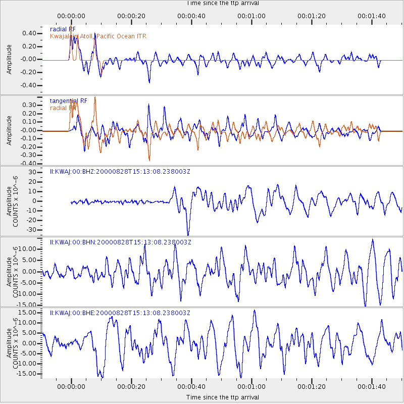
Signal To Noise
| Channel | StoN | STA | LTA |
| II:KWAJ:00:BHN:20000828T15:13:08.238003Z | 1.2864498 | 1.9036318E-6 | 1.479756E-6 |
| II:KWAJ:00:BHE:20000828T15:13:08.238003Z | 0.71950215 | 1.6916933E-6 | 2.3511998E-6 |
| II:KWAJ:00:BHZ:20000828T15:13:08.238003Z | 5.242064 | 5.446615E-6 | 1.0390211E-6 |
| Arrivals |
| Ps | 2.0 SECOND |
| PpPs | 8.0 SECOND |
| PsPs/PpSs | 10.0 SECOND |


