You are here: Home > Network List > II - Global Seismograph Network (GSN - IRIS/IDA) Stations List
> Station KWAJ Kwajalein Atoll, Pacific Ocean > Earthquake Result Viewer
KWAJ Kwajalein Atoll, Pacific Ocean - Earthquake Result Viewer

| Earthquake location: |
Tonga Islands |
| Earthquake latitude/longitude: |
-16.9/-174.2 |
| Earthquake time(UTC): |
2000/01/08 (008) 16:47:20 GMT |
| Earthquake Depth: |
183 km |
| Earthquake Magnitude: |
6.5 MB, 6.6 MS, 7.2 MW, 7.0 ME |
| Earthquake Catalog/Contributor: |
WHDF/NEIC |
|
| Network: |
II Global Seismograph Network (GSN - IRIS/IDA) |
| Station: |
KWAJ Kwajalein Atoll, Pacific Ocean |
| Lat/Lon: |
8.80 N/167.61 E |
| Elevation: |
0.0 m |
|
| Distance: |
31.2 deg |
| Az: |
323.594 deg |
| Baz: |
144.915 deg |
| Ray Param: |
0.07862172 |
| Estimated Moho Depth: |
20.0 km |
| Estimated Crust Vp/Vs: |
2.09 |
| Assumed Crust Vp: |
4.802 km/s |
| Estimated Crust Vs: |
2.298 km/s |
| Estimated Crust Poisson's Ratio: |
0.35 |
|
| Radial Match: |
81.217705 % |
| Radial Bump: |
400 |
| Transverse Match: |
71.33536 % |
| Transverse Bump: |
400 |
| SOD ConfigId: |
3744 |
| Insert Time: |
2010-03-02 00:05:44.549 +0000 |
| GWidth: |
2.5 |
| Max Bumps: |
400 |
| Tol: |
0.001 |
|
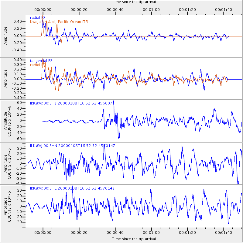
Signal To Noise
| Channel | StoN | STA | LTA |
| II:KWAJ:00:BHN:20000108T16:52:52.457014Z | 1.4987946 | 6.7847327E-6 | 4.526793E-6 |
| II:KWAJ:00:BHE:20000108T16:52:52.457014Z | 1.6174576 | 5.129091E-6 | 3.1710822E-6 |
| II:KWAJ:00:BHZ:20000108T16:52:52.456007Z | 5.4580507 | 1.4394924E-5 | 2.6373746E-6 |
| Arrivals |
| Ps | 4.7 SECOND |
| PpPs | 12 SECOND |
| PsPs/PpSs | 17 SECOND |


