You are here: Home > Network List > XL12 - Hangay Dome, Mongolia Stations List
> Station AT08 AT08 > Earthquake Result Viewer
AT08 AT08 - Earthquake Result Viewer
| Earthquake location: |
Tanimbar Islands Reg., Indonesia |
| Earthquake latitude/longitude: |
-6.9/132.5 |
| Earthquake time(UTC): |
2015/04/01 (091) 09:35:58 GMT |
| Earthquake Depth: |
24 km |
| Earthquake Magnitude: |
5.8 MB |
| Earthquake Catalog/Contributor: |
NEIC PDE/NEIC COMCAT |
|
| Network: |
XL Hangay Dome, Mongolia |
| Station: |
AT08 AT08 |
| Lat/Lon: |
45.56 N/95.88 E |
| Elevation: |
2056 m |
|
| Distance: |
61.7 deg |
| Az: |
331.576 deg |
| Baz: |
137.729 deg |
| Ray Param: |
0.060689054 |
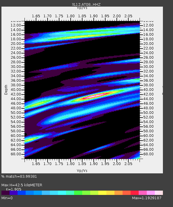
| Estimated Moho Depth: |
42.5 km |
| Estimated Crust Vp/Vs: |
1.90 |
| Assumed Crust Vp: |
6.353 km/s |
| Estimated Crust Vs: |
3.335 km/s |
| Estimated Crust Poisson's Ratio: |
0.31 |
|
| Radial Match: |
83.99381 % |
| Radial Bump: |
400 |
| Transverse Match: |
81.70656 % |
| Transverse Bump: |
400 |
| SOD ConfigId: |
7422571 |
| Insert Time: |
2019-04-18 01:02:00.161 +0000 |
| GWidth: |
2.5 |
| Max Bumps: |
400 |
| Tol: |
0.001 |
|

Signal To Noise
| Channel | StoN | STA | LTA |
| XL:AT08: :HHZ:20150401T09:45:43.388994Z | 5.247385 | 2.3503034E-7 | 4.4789996E-8 |
| XL:AT08: :HHN:20150401T09:45:43.388994Z | 2.0585203 | 1.0186615E-7 | 4.948513E-8 |
| XL:AT08: :HHE:20150401T09:45:43.388994Z | 3.450168 | 8.678251E-8 | 2.5153126E-8 |
| Arrivals |
| Ps | 6.3 SECOND |
| PpPs | 19 SECOND |
| PsPs/PpSs | 25 SECOND |


