You are here: Home > Network List > TA - USArray Transportable Network (new EarthScope stations) Stations List
> Station L65A Cape Cod National Seashore, MA, USA > Earthquake Result Viewer
L65A Cape Cod National Seashore, MA, USA - Earthquake Result Viewer
| Earthquake location: |
Kuril Islands |
| Earthquake latitude/longitude: |
44.6/148.7 |
| Earthquake time(UTC): |
2014/07/20 (201) 18:32:47 GMT |
| Earthquake Depth: |
61 km |
| Earthquake Magnitude: |
6.6 MB |
| Earthquake Catalog/Contributor: |
NEIC PDE/NEIC COMCAT |
|
| Network: |
TA USArray Transportable Network (new EarthScope stations) |
| Station: |
L65A Cape Cod National Seashore, MA, USA |
| Lat/Lon: |
42.03 N/70.05 W |
| Elevation: |
50 m |
|
| Distance: |
87.0 deg |
| Az: |
27.858 deg |
| Baz: |
333.393 deg |
| Ray Param: |
0.0435264 |
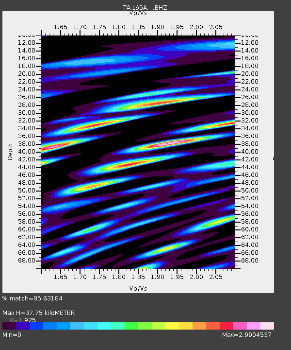
| Estimated Moho Depth: |
37.75 km |
| Estimated Crust Vp/Vs: |
1.92 |
| Assumed Crust Vp: |
6.419 km/s |
| Estimated Crust Vs: |
3.335 km/s |
| Estimated Crust Poisson's Ratio: |
0.32 |
|
| Radial Match: |
85.63184 % |
| Radial Bump: |
400 |
| Transverse Match: |
80.202805 % |
| Transverse Bump: |
400 |
| SOD ConfigId: |
751272 |
| Insert Time: |
2014-08-04 16:17:09.436 +0000 |
| GWidth: |
2.5 |
| Max Bumps: |
400 |
| Tol: |
0.001 |
|

Signal To Noise
| Channel | StoN | STA | LTA |
| TA:L65A: :BHZ:20140720T18:44:55.10002Z | 4.4174843 | 4.615432E-6 | 1.04481E-6 |
| TA:L65A: :BHN:20140720T18:44:55.10002Z | 2.7315433 | 4.0632176E-6 | 1.4875171E-6 |
| TA:L65A: :BHE:20140720T18:44:55.10002Z | 1.6335796 | 2.2621743E-6 | 1.3847958E-6 |
| Arrivals |
| Ps | 5.6 SECOND |
| PpPs | 17 SECOND |
| PsPs/PpSs | 22 SECOND |


