You are here: Home > Network List > TA - USArray Transportable Network (new EarthScope stations) Stations List
> Station N63A Mattituck, NY, USA > Earthquake Result Viewer
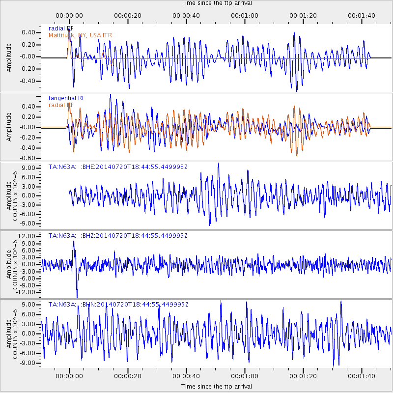
N63A Mattituck, NY, USA - Earthquake Result Viewer
*The percent match for this event was below the threshold and hence no stack was calculated.
| Earthquake location: |
Kuril Islands |
| Earthquake latitude/longitude: |
44.6/148.7 |
| Earthquake time(UTC): |
2014/07/20 (201) 18:32:47 GMT |
| Earthquake Depth: |
61 km |
| Earthquake Magnitude: |
6.6 MB |
| Earthquake Catalog/Contributor: |
NEIC PDE/NEIC COMCAT |
|
| Network: |
TA USArray Transportable Network (new EarthScope stations) |
| Station: |
N63A Mattituck, NY, USA |
| Lat/Lon: |
40.99 N/72.52 W |
| Elevation: |
8.0 m |
|
| Distance: |
87.1 deg |
| Az: |
29.985 deg |
| Baz: |
331.874 deg |
| Ray Param: |
$rayparam |
*The percent match for this event was below the threshold and hence was not used in the summary stack. |
|
| Radial Match: |
73.88069 % |
| Radial Bump: |
400 |
| Transverse Match: |
68.1148 % |
| Transverse Bump: |
400 |
| SOD ConfigId: |
751272 |
| Insert Time: |
2014-08-04 16:19:30.637 +0000 |
| GWidth: |
2.5 |
| Max Bumps: |
400 |
| Tol: |
0.001 |
|
Signal To Noise
| Channel | StoN | STA | LTA |
| TA:N63A: :BHZ:20140720T18:44:55.449995Z | 2.7609417 | 4.87679E-6 | 1.7663504E-6 |
| TA:N63A: :BHN:20140720T18:44:55.449995Z | 1.3004688 | 3.5781882E-6 | 2.7514604E-6 |
| TA:N63A: :BHE:20140720T18:44:55.449995Z | 1.5560733 | 2.809382E-6 | 1.8054304E-6 |
| Arrivals |
| Ps | |
| PpPs | |
| PsPs/PpSs | |


