You are here: Home > Network List > TA - USArray Transportable Network (new EarthScope stations) Stations List
> Station M66A Nantucket, MA, USA > Earthquake Result Viewer
M66A Nantucket, MA, USA - Earthquake Result Viewer
| Earthquake location: |
Central Peru |
| Earthquake latitude/longitude: |
-14.6/-73.6 |
| Earthquake time(UTC): |
2014/08/24 (236) 23:21:45 GMT |
| Earthquake Depth: |
101 km |
| Earthquake Magnitude: |
6.9 MWW, 6.8 MI, 6.9 MWB |
| Earthquake Catalog/Contributor: |
NEIC PDE/NEIC COMCAT |
|
| Network: |
TA USArray Transportable Network (new EarthScope stations) |
| Station: |
M66A Nantucket, MA, USA |
| Lat/Lon: |
41.26 N/70.14 W |
| Elevation: |
9.0 m |
|
| Distance: |
55.7 deg |
| Az: |
3.143 deg |
| Baz: |
184.038 deg |
| Ray Param: |
0.06434903 |
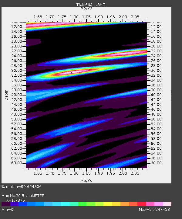
| Estimated Moho Depth: |
30.5 km |
| Estimated Crust Vp/Vs: |
1.79 |
| Assumed Crust Vp: |
6.472 km/s |
| Estimated Crust Vs: |
3.621 km/s |
| Estimated Crust Poisson's Ratio: |
0.27 |
|
| Radial Match: |
90.624306 % |
| Radial Bump: |
400 |
| Transverse Match: |
75.968475 % |
| Transverse Bump: |
400 |
| SOD ConfigId: |
769524 |
| Insert Time: |
2014-09-08 00:05:01.890 +0000 |
| GWidth: |
2.5 |
| Max Bumps: |
400 |
| Tol: |
0.001 |
|
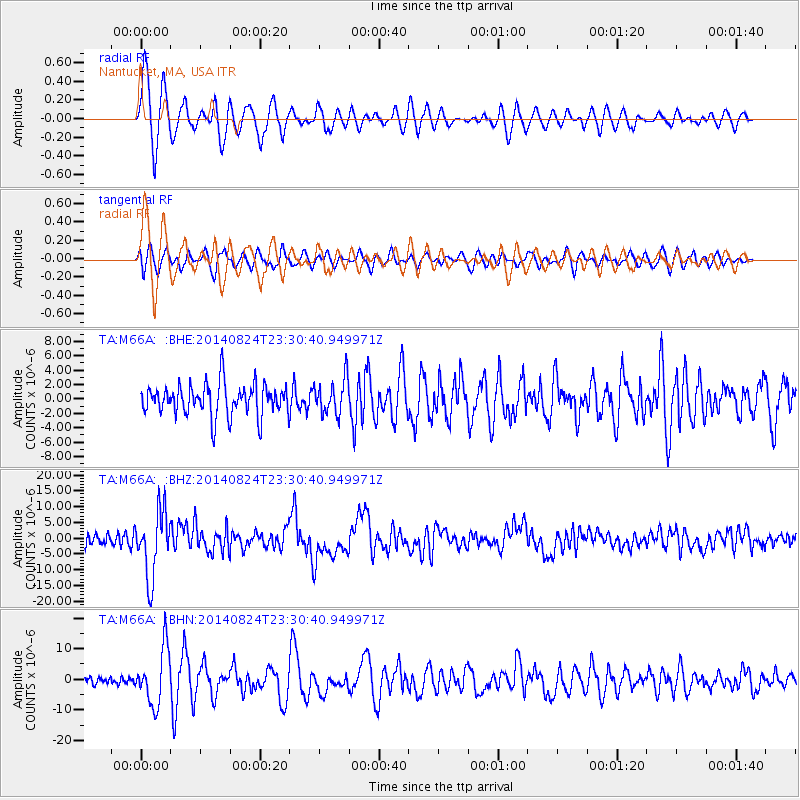
Signal To Noise
| Channel | StoN | STA | LTA |
| TA:M66A: :BHZ:20140824T23:30:40.949971Z | 5.745401 | 1.0425813E-5 | 1.8146363E-6 |
| TA:M66A: :BHN:20140824T23:30:40.949971Z | 4.905995 | 9.162533E-6 | 1.8676199E-6 |
| TA:M66A: :BHE:20140824T23:30:40.949971Z | 1.124264 | 2.48592E-6 | 2.2111533E-6 |
| Arrivals |
| Ps | 3.9 SECOND |
| PpPs | 12 SECOND |
| PsPs/PpSs | 16 SECOND |


