You are here: Home > Network List > TA - USArray Transportable Network (new EarthScope stations) Stations List
> Station N63A Mattituck, NY, USA > Earthquake Result Viewer
N63A Mattituck, NY, USA - Earthquake Result Viewer
| Earthquake location: |
Central Peru |
| Earthquake latitude/longitude: |
-14.6/-73.6 |
| Earthquake time(UTC): |
2014/08/24 (236) 23:21:45 GMT |
| Earthquake Depth: |
101 km |
| Earthquake Magnitude: |
6.9 MWW, 6.8 MI, 6.9 MWB |
| Earthquake Catalog/Contributor: |
NEIC PDE/NEIC COMCAT |
|
| Network: |
TA USArray Transportable Network (new EarthScope stations) |
| Station: |
N63A Mattituck, NY, USA |
| Lat/Lon: |
40.99 N/72.52 W |
| Elevation: |
8.0 m |
|
| Distance: |
55.3 deg |
| Az: |
0.973 deg |
| Baz: |
181.245 deg |
| Ray Param: |
0.064577915 |
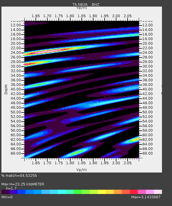
| Estimated Moho Depth: |
23.25 km |
| Estimated Crust Vp/Vs: |
1.70 |
| Assumed Crust Vp: |
6.472 km/s |
| Estimated Crust Vs: |
3.807 km/s |
| Estimated Crust Poisson's Ratio: |
0.24 |
|
| Radial Match: |
84.53255 % |
| Radial Bump: |
400 |
| Transverse Match: |
74.060844 % |
| Transverse Bump: |
400 |
| SOD ConfigId: |
769524 |
| Insert Time: |
2014-09-08 00:05:39.481 +0000 |
| GWidth: |
2.5 |
| Max Bumps: |
400 |
| Tol: |
0.001 |
|
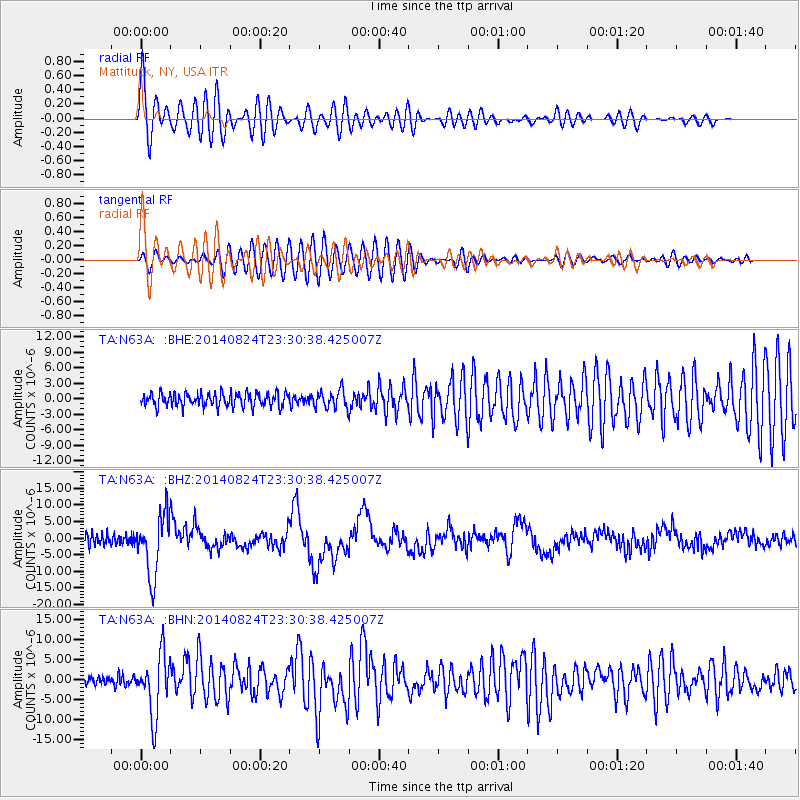
Signal To Noise
| Channel | StoN | STA | LTA |
| TA:N63A: :BHZ:20140824T23:30:38.425007Z | 6.4101386 | 9.13531E-6 | 1.4251347E-6 |
| TA:N63A: :BHN:20140824T23:30:38.425007Z | 5.1676764 | 7.618202E-6 | 1.4742026E-6 |
| TA:N63A: :BHE:20140824T23:30:38.425007Z | 1.3264663 | 1.7124219E-6 | 1.2909652E-6 |
| Arrivals |
| Ps | 2.7 SECOND |
| PpPs | 9.2 SECOND |
| PsPs/PpSs | 12 SECOND |


