You are here: Home > Network List > TA - USArray Transportable Network (new EarthScope stations) Stations List
> Station L65A Cape Cod National Seashore, MA, USA > Earthquake Result Viewer
L65A Cape Cod National Seashore, MA, USA - Earthquake Result Viewer
| Earthquake location: |
Off Coast Of Central America |
| Earthquake latitude/longitude: |
12.6/-88.0 |
| Earthquake time(UTC): |
2014/10/14 (287) 03:51:35 GMT |
| Earthquake Depth: |
40 km |
| Earthquake Magnitude: |
7.3 MWW, 7.4 MI |
| Earthquake Catalog/Contributor: |
NEIC PDE/NEIC COMCAT |
|
| Network: |
TA USArray Transportable Network (new EarthScope stations) |
| Station: |
L65A Cape Cod National Seashore, MA, USA |
| Lat/Lon: |
42.03 N/70.05 W |
| Elevation: |
50 m |
|
| Distance: |
33.3 deg |
| Az: |
24.807 deg |
| Baz: |
213.354 deg |
| Ray Param: |
0.07821098 |
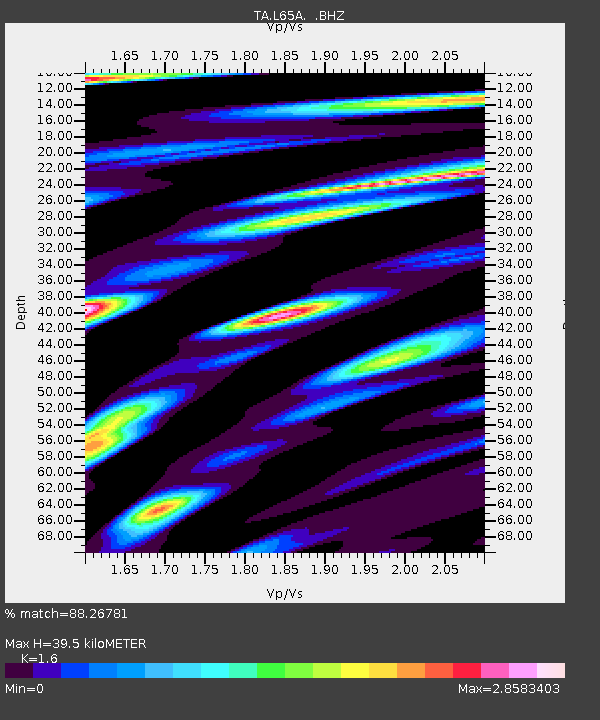
| Estimated Moho Depth: |
39.5 km |
| Estimated Crust Vp/Vs: |
1.60 |
| Assumed Crust Vp: |
6.419 km/s |
| Estimated Crust Vs: |
4.012 km/s |
| Estimated Crust Poisson's Ratio: |
0.18 |
|
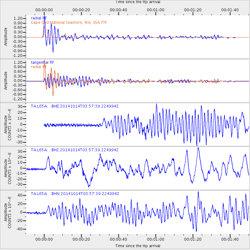
| Radial Match: |
88.26781 % |
| Radial Bump: |
400 |
| Transverse Match: |
71.4164 % |
| Transverse Bump: |
400 |
| SOD ConfigId: |
803114 |
| Insert Time: |
2014-10-28 04:30:35.383 +0000 |
| GWidth: |
2.5 |
| Max Bumps: |
400 |
| Tol: |
0.001 |
|
Signal To Noise
| Channel | StoN | STA | LTA |
| TA:L65A: :BHZ:20141014T03:57:39.224994Z | 13.5935545 | 9.418339E-6 | 6.928533E-7 |
| TA:L65A: :BHN:20141014T03:57:39.224994Z | 8.368012 | 7.0279607E-6 | 8.398602E-7 |
| TA:L65A: :BHE:20141014T03:57:39.224994Z | 4.215588 | 4.72578E-6 | 1.121025E-6 |
| Arrivals |
| Ps | 4.0 SECOND |
| PpPs | 15 SECOND |
| PsPs/PpSs | 19 SECOND |


