You are here: Home > Network List > TA - USArray Transportable Network (new EarthScope stations) Stations List
> Station M66A Nantucket, MA, USA > Earthquake Result Viewer
M66A Nantucket, MA, USA - Earthquake Result Viewer
| Earthquake location: |
Off Coast Of Central America |
| Earthquake latitude/longitude: |
12.6/-88.0 |
| Earthquake time(UTC): |
2014/10/14 (287) 03:51:35 GMT |
| Earthquake Depth: |
40 km |
| Earthquake Magnitude: |
7.3 MWW, 7.4 MI |
| Earthquake Catalog/Contributor: |
NEIC PDE/NEIC COMCAT |
|
| Network: |
TA USArray Transportable Network (new EarthScope stations) |
| Station: |
M66A Nantucket, MA, USA |
| Lat/Lon: |
41.26 N/70.14 W |
| Elevation: |
9.0 m |
|
| Distance: |
32.6 deg |
| Az: |
25.496 deg |
| Baz: |
213.878 deg |
| Ray Param: |
0.07851647 |
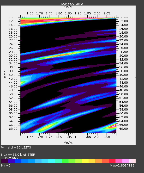
| Estimated Moho Depth: |
66.0 km |
| Estimated Crust Vp/Vs: |
2.10 |
| Assumed Crust Vp: |
6.472 km/s |
| Estimated Crust Vs: |
3.089 km/s |
| Estimated Crust Poisson's Ratio: |
0.35 |
|
| Radial Match: |
95.12273 % |
| Radial Bump: |
244 |
| Transverse Match: |
81.38402 % |
| Transverse Bump: |
400 |
| SOD ConfigId: |
803114 |
| Insert Time: |
2014-10-28 04:31:06.888 +0000 |
| GWidth: |
2.5 |
| Max Bumps: |
400 |
| Tol: |
0.001 |
|
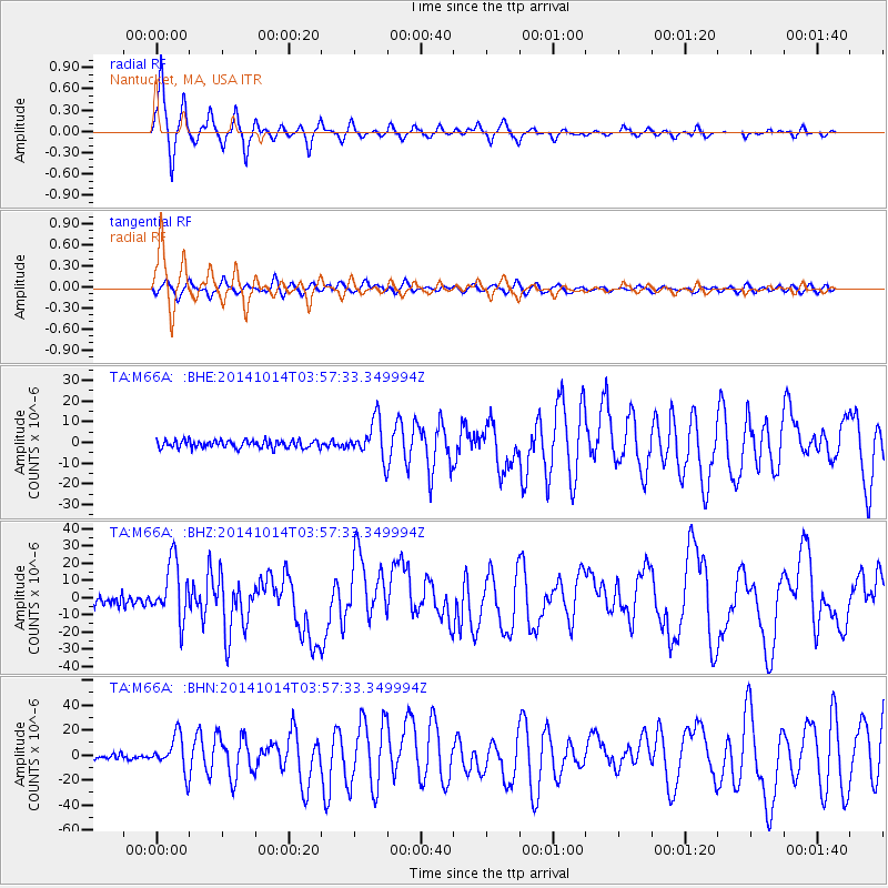
Signal To Noise
| Channel | StoN | STA | LTA |
| TA:M66A: :BHZ:20141014T03:57:33.349994Z | 6.709691 | 1.683293E-5 | 2.5087488E-6 |
| TA:M66A: :BHN:20141014T03:57:33.349994Z | 7.482382 | 1.3897307E-5 | 1.8573372E-6 |
| TA:M66A: :BHE:20141014T03:57:33.349994Z | 4.957172 | 9.215385E-6 | 1.8590006E-6 |
| Arrivals |
| Ps | 12 SECOND |
| PpPs | 30 SECOND |
| PsPs/PpSs | 41 SECOND |


