You are here: Home > Network List > IC - New China Digital Seismograph Network Stations List
> Station HIA Hailar, Neimenggu Autonomous Region, China > Earthquake Result Viewer
HIA Hailar, Neimenggu Autonomous Region, China - Earthquake Result Viewer
*The percent match for this event was below the threshold and hence no stack was calculated.
| Earthquake location: |
Bali Sea |
| Earthquake latitude/longitude: |
-7.0/117.6 |
| Earthquake time(UTC): |
2014/10/30 (303) 12:11:36 GMT |
| Earthquake Depth: |
546 km |
| Earthquake Magnitude: |
5.7 MB |
| Earthquake Catalog/Contributor: |
NEIC PDE/NEIC COMCAT |
|
| Network: |
IC New China Digital Seismograph Network |
| Station: |
HIA Hailar, Neimenggu Autonomous Region, China |
| Lat/Lon: |
49.27 N/119.74 E |
| Elevation: |
620 m |
|
| Distance: |
56.0 deg |
| Az: |
1.692 deg |
| Baz: |
182.565 deg |
| Ray Param: |
$rayparam |
*The percent match for this event was below the threshold and hence was not used in the summary stack. |
|
| Radial Match: |
63.070576 % |
| Radial Bump: |
400 |
| Transverse Match: |
55.67083 % |
| Transverse Bump: |
400 |
| SOD ConfigId: |
812614 |
| Insert Time: |
2014-11-13 12:24:14.776 +0000 |
| GWidth: |
2.5 |
| Max Bumps: |
400 |
| Tol: |
0.001 |
|
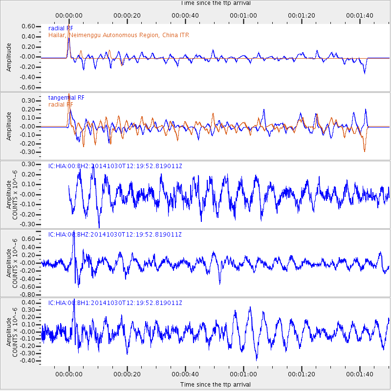
Signal To Noise
| Channel | StoN | STA | LTA |
| IC:HIA:00:BHZ:20141030T12:19:52.819011Z | 3.7311804 | 3.1737E-7 | 8.505887E-8 |
| IC:HIA:00:BH1:20141030T12:19:52.819011Z | 1.5222974 | 1.6310092E-7 | 1.071413E-7 |
| IC:HIA:00:BH2:20141030T12:19:52.819011Z | 0.75929576 | 9.164558E-8 | 1.2069813E-7 |
| Arrivals |
| Ps | |
| PpPs | |
| PsPs/PpSs | |


