You are here: Home > Network List > IC - New China Digital Seismograph Network Stations List
> Station HIA Hailar, Neimenggu Autonomous Region, China > Earthquake Result Viewer
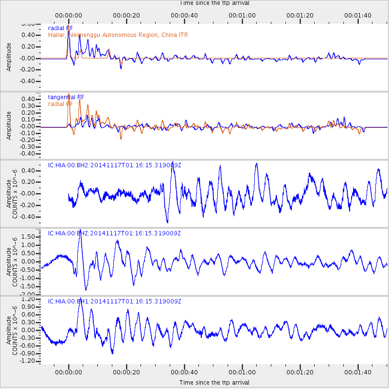
HIA Hailar, Neimenggu Autonomous Region, China - Earthquake Result Viewer
*The percent match for this event was below the threshold and hence no stack was calculated.
| Earthquake location: |
D'Entrecasteaux Islands Region |
| Earthquake latitude/longitude: |
-9.6/155.2 |
| Earthquake time(UTC): |
2014/11/17 (321) 01:06:00 GMT |
| Earthquake Depth: |
25 km |
| Earthquake Magnitude: |
6.1 MWP |
| Earthquake Catalog/Contributor: |
NEIC PDE/NEIC COMCAT |
|
| Network: |
IC New China Digital Seismograph Network |
| Station: |
HIA Hailar, Neimenggu Autonomous Region, China |
| Lat/Lon: |
49.27 N/119.74 E |
| Elevation: |
620 m |
|
| Distance: |
66.3 deg |
| Az: |
335.513 deg |
| Baz: |
141.382 deg |
| Ray Param: |
$rayparam |
*The percent match for this event was below the threshold and hence was not used in the summary stack. |
|
| Radial Match: |
79.24857 % |
| Radial Bump: |
400 |
| Transverse Match: |
84.88663 % |
| Transverse Bump: |
400 |
| SOD ConfigId: |
818264 |
| Insert Time: |
2014-12-01 01:20:55.082 +0000 |
| GWidth: |
2.5 |
| Max Bumps: |
400 |
| Tol: |
0.001 |
|
Signal To Noise
| Channel | StoN | STA | LTA |
| IC:HIA:00:BHZ:20141117T01:16:15.319009Z | 2.8149328 | 8.33882E-7 | 2.9623513E-7 |
| IC:HIA:00:BH1:20141117T01:16:15.319009Z | 1.9023415 | 5.552996E-7 | 2.919032E-7 |
| IC:HIA:00:BH2:20141117T01:16:15.319009Z | 2.3657556 | 1.9572181E-7 | 8.2731205E-8 |
| Arrivals |
| Ps | |
| PpPs | |
| PsPs/PpSs | |


