You are here: Home > Network List > IC - New China Digital Seismograph Network Stations List
> Station HIA Hailar, Neimenggu Autonomous Region, China > Earthquake Result Viewer
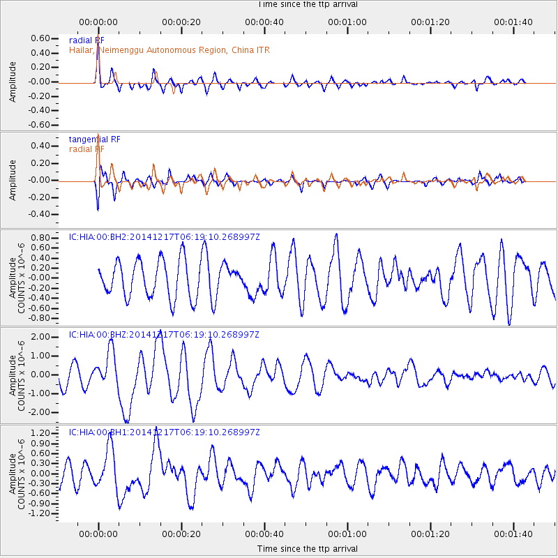
HIA Hailar, Neimenggu Autonomous Region, China - Earthquake Result Viewer
*The percent match for this event was below the threshold and hence no stack was calculated.
| Earthquake location: |
Southern Sumatra, Indonesia |
| Earthquake latitude/longitude: |
-3.9/100.1 |
| Earthquake time(UTC): |
2014/12/17 (351) 06:10:05 GMT |
| Earthquake Depth: |
10 km |
| Earthquake Magnitude: |
5.6 MB |
| Earthquake Catalog/Contributor: |
NEIC PDE/NEIC COMCAT |
|
| Network: |
IC New China Digital Seismograph Network |
| Station: |
HIA Hailar, Neimenggu Autonomous Region, China |
| Lat/Lon: |
49.27 N/119.74 E |
| Elevation: |
620 m |
|
| Distance: |
55.7 deg |
| Az: |
15.443 deg |
| Baz: |
203.928 deg |
| Ray Param: |
$rayparam |
*The percent match for this event was below the threshold and hence was not used in the summary stack. |
|
| Radial Match: |
78.86222 % |
| Radial Bump: |
400 |
| Transverse Match: |
74.57108 % |
| Transverse Bump: |
400 |
| SOD ConfigId: |
826271 |
| Insert Time: |
2014-12-31 06:34:36.572 +0000 |
| GWidth: |
2.5 |
| Max Bumps: |
400 |
| Tol: |
0.001 |
|
Signal To Noise
| Channel | StoN | STA | LTA |
| IC:HIA:00:BHZ:20141217T06:19:10.268997Z | 2.2231658 | 9.84605E-7 | 4.4288421E-7 |
| IC:HIA:00:BH1:20141217T06:19:10.268997Z | 2.2182238 | 6.548653E-7 | 2.9522056E-7 |
| IC:HIA:00:BH2:20141217T06:19:10.268997Z | 0.56735146 | 2.0854219E-7 | 3.6757143E-7 |
| Arrivals |
| Ps | |
| PpPs | |
| PsPs/PpSs | |


