You are here: Home > Network List > IU - Global Seismograph Network (GSN - IRIS/USGS) Stations List
> Station KOWA Kowa, Mali > Earthquake Result Viewer
KOWA Kowa, Mali - Earthquake Result Viewer
| Earthquake location: |
Near Coast Of Peru |
| Earthquake latitude/longitude: |
-16.7/-72.7 |
| Earthquake time(UTC): |
1999/04/03 (093) 06:17:18 GMT |
| Earthquake Depth: |
87 km |
| Earthquake Magnitude: |
6.1 MB, 6.2 MS, 6.8 MW, 6.8 MW |
| Earthquake Catalog/Contributor: |
WHDF/NEIC |
|
| Network: |
IU Global Seismograph Network (GSN - IRIS/USGS) |
| Station: |
KOWA Kowa, Mali |
| Lat/Lon: |
14.50 N/4.01 W |
| Elevation: |
321 m |
|
| Distance: |
74.5 deg |
| Az: |
69.408 deg |
| Baz: |
247.885 deg |
| Ray Param: |
0.05208762 |
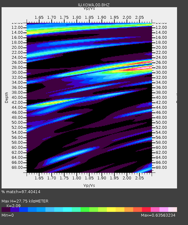
| Estimated Moho Depth: |
27.75 km |
| Estimated Crust Vp/Vs: |
2.09 |
| Assumed Crust Vp: |
6.31 km/s |
| Estimated Crust Vs: |
3.019 km/s |
| Estimated Crust Poisson's Ratio: |
0.35 |
|
| Radial Match: |
97.40414 % |
| Radial Bump: |
400 |
| Transverse Match: |
91.29847 % |
| Transverse Bump: |
400 |
| SOD ConfigId: |
4480 |
| Insert Time: |
2010-03-02 15:07:20.153 +0000 |
| GWidth: |
2.5 |
| Max Bumps: |
400 |
| Tol: |
0.001 |
|
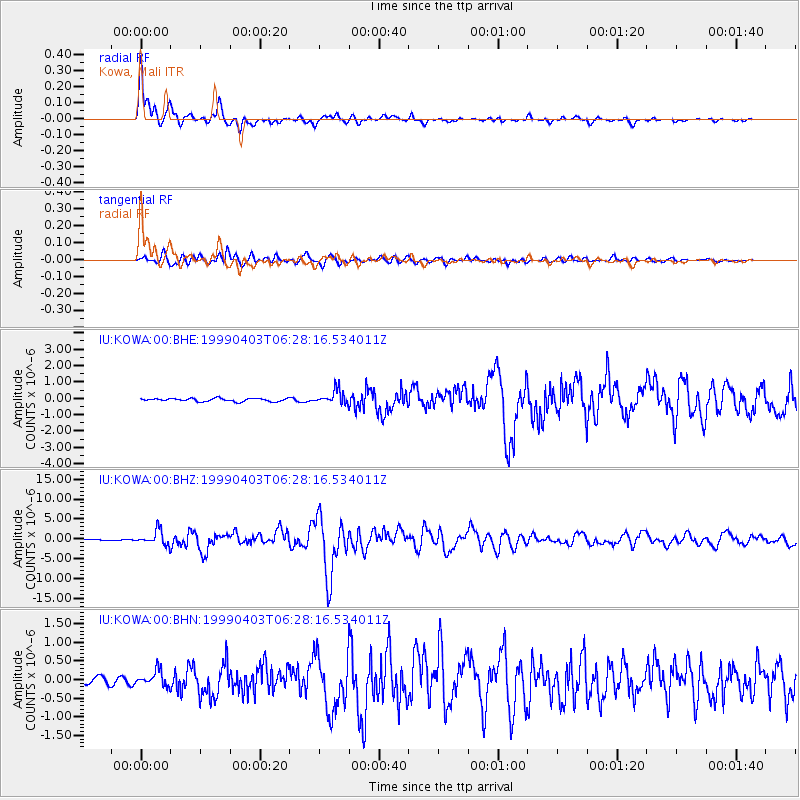
Signal To Noise
| Channel | StoN | STA | LTA |
| IU:KOWA:00:BHZ:19990403T06:28:16.534011Z | 16.096869 | 1.8096312E-6 | 1.1242132E-7 |
| IU:KOWA:00:BHN:19990403T06:28:16.534011Z | 2.1319888 | 2.0140222E-7 | 9.446683E-8 |
| IU:KOWA:00:BHE:19990403T06:28:16.534011Z | 4.6356754 | 4.279983E-7 | 9.232706E-8 |
| Arrivals |
| Ps | 4.9 SECOND |
| PpPs | 13 SECOND |
| PsPs/PpSs | 18 SECOND |


