You are here: Home > Network List > SN - Southern Great Basin Network Stations List
> Station RVSE Rock Valley SPE, Southeast, wgs84 > Earthquake Result Viewer
RVSE Rock Valley SPE, Southeast, wgs84 - Earthquake Result Viewer
| Earthquake location: |
Santa Cruz Islands Region |
| Earthquake latitude/longitude: |
-10.9/164.2 |
| Earthquake time(UTC): |
2015/05/20 (140) 22:48:53 GMT |
| Earthquake Depth: |
12 km |
| Earthquake Magnitude: |
6.8 MWW, 6.7 MWB, 6.8 MWC, 6.9 MI |
| Earthquake Catalog/Contributor: |
NEIC PDE/NEIC COMCAT |
|
| Network: |
SN Southern Great Basin Network |
| Station: |
RVSE Rock Valley SPE, Southeast, wgs84 |
| Lat/Lon: |
36.70 N/116.10 W |
| Elevation: |
1157 m |
|
| Distance: |
88.3 deg |
| Az: |
52.3 deg |
| Baz: |
255.226 deg |
| Ray Param: |
0.04265307 |
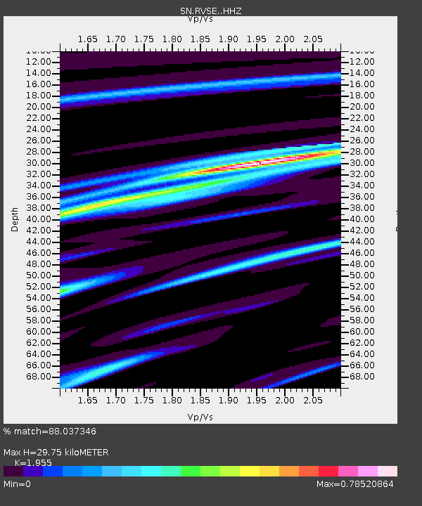
| Estimated Moho Depth: |
29.75 km |
| Estimated Crust Vp/Vs: |
1.96 |
| Assumed Crust Vp: |
6.279 km/s |
| Estimated Crust Vs: |
3.212 km/s |
| Estimated Crust Poisson's Ratio: |
0.32 |
|
| Radial Match: |
88.037346 % |
| Radial Bump: |
400 |
| Transverse Match: |
62.439053 % |
| Transverse Bump: |
400 |
| SOD ConfigId: |
7422571 |
| Insert Time: |
2019-04-18 23:53:43.109 +0000 |
| GWidth: |
2.5 |
| Max Bumps: |
400 |
| Tol: |
0.001 |
|

Signal To Noise
| Channel | StoN | STA | LTA |
| SN:RVSE: :HHZ:20150520T23:01:13.649976Z | 8.524329 | 6.807358E-7 | 7.985799E-8 |
| SN:RVSE: :HHN:20150520T23:01:13.649976Z | 1.272759 | 3.3518938E-7 | 2.6335653E-7 |
| SN:RVSE: :HHE:20150520T23:01:13.649976Z | 2.5877538 | 2.0818851E-7 | 8.0451436E-8 |
| Arrivals |
| Ps | 4.6 SECOND |
| PpPs | 14 SECOND |
| PsPs/PpSs | 18 SECOND |


