
Station SN RVSE - Rock Valley SPE, Southeast, wgs84
Network: SN - Southern Great Basin Network
Nearby stations (2 deg radius)
| Station | Name | (Lat, Lon) | Start / End | Elevation |
| RVSE | Rock Valley SPE, Southeast, wgs84 | (36.70, -116.10) | 2012-03-06 / 2599-12-31 | 1157 m |
| Crust2 Type: | M7,medium thick extended crust, 0.5 km seds. |
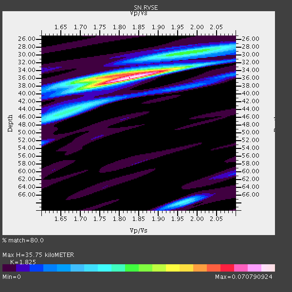
| Thickness Estimate: | 36 km |
| Thickness StdDev: | 2.3 km |
| Vp/Vs Estimate: | 1.83 |
| Vp/Vs StdDev: | 0.07 |
| Vs Estimate: | 3.44 km/s |
| Poisson's Ratio: | 0.29 |
| Peak Value: | 0.07 |
| Assumed Vp: | 6.279 km/s |
| Ps Weight: | 0.33333334 |
| PpPs Weight: | 0.33333334 |
| PsPs Weight: | 0.33333328 |
| Residual Complexity: | 0.505 |
| Nearby stations H: | +- |
| (2.0 deg) Vp/Vs: | +- |
1 with match > 90% ( 5.263158 %) and 3 with match > 80% ( 15.789474 %) out of 19.
Download stack as xyz text file.
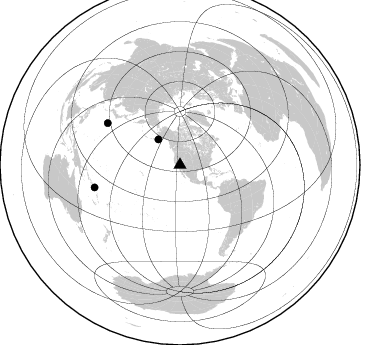
Azimuth Distribution of Events:
Prior Results for this Station
| Study | Thickness | Vp/Vs | Vp | Vs | Poissons Ratio | Extra |
| EARS | 36 km | 1.83 | 6.279 km/s | 3.44 km/s | 0.29 | |
| Crust2.0 | 35 km | 1.78 | 6.279 km/s | 3.533 km/s | 0.27 | M7,medium thick extended crust, 0.5 km seds. |
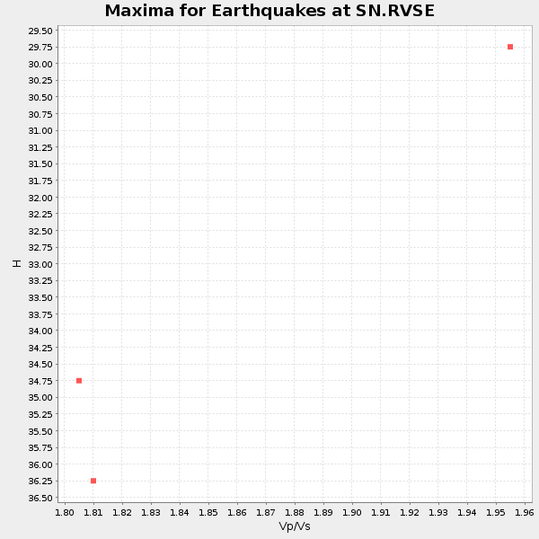
| Global Maxima | 36 km | 1.83 | 6.279 km/s | 3.44 km/s | 0.29 | amp=0.070790924 |
| Local Maxima 1 | 36 km | 1.76 | 6.279 km/s | 3.572 km/s | 0.26 | amp=0.03778674 |
| Local Maxima 2 | 68 km | 1.96 | 6.279 km/s | 3.203 km/s | 0.32 | amp=0.027427087 |
| Local Maxima 3 | 46 km | 1.65 | 6.279 km/s | 3.799 km/s | 0.21 | amp=0.021235174 |
| Local Maxima 4 | 29 km | 1.98 | 6.279 km/s | 3.171 km/s | 0.33 | amp=0.019064508 |
| Predicted Arrivals for vertical incidence (zero ray parameter) | |
| Ps | 4.70 SECOND |
| PpPs | 16.09 SECOND |
| PsPs/PpSs | 20.78 SECOND |
Events Processed for this Station
Download zip of receiver functions as SAC
Plot maxima for each earthquake.
Events Used in the Stack
(3 events)| Radial Match | Distance | Baz | FERegion | Time | Lat/Lon | Depth | Magnitude |
| 90.77176 | 83.6 deg | 299.904 deg | Bonin Islands, Japan Region | 2015/05/30 11:23:02 GMT | (27.8, 140.5) | 678 km | 7.8 MWP, 8.5 MI |
| 89.87107 | 33.5 deg | 319.607 deg | Alaska Peninsula | 2015/05/29 07:00:08 GMT | (56.7, -156.5) | 62 km | 6.8 MWP, 6.8 MI |
| 88.037346 | 88.3 deg | 255.226 deg | Santa Cruz Islands Region | 2015/05/20 22:48:53 GMT | (-10.9, 164.2) | 12 km | 6.8 MWW, 6.7 MWB, 6.8 MWC, 6.9 MI |
Losers
(16 events)| Radial Match | Distance | Baz | FERegion | Time | Lat/Lon | Depth | Magnitude | Reason |
| 70.318085 | 88.8 deg | 255.354 deg | Solomon Islands | 2015/05/22 21:45:18 GMT | (-11.1, 163.7) | 7.9 km | 6.8 MO | |
| 70.07242 | 75.0 deg | 236.949 deg | Tonga Islands | 2015/05/30 17:18:39 GMT | (-15.7, -173.3) | 51 km | 5.8 MB | |
| 63.479214 | 79.0 deg | 235.887 deg | Tonga Islands | 2015/05/20 00:30:51 GMT | (-19.3, -175.5) | 180 km | 6.0 MWP | |
| 55.281612 | 80.1 deg | 300.896 deg | Southeast Of Honshu, Japan | 2015/05/30 18:49:07 GMT | (30.8, 143.0) | 13 km | 6.4 MO | |
| 54.710327 | 90.7 deg | 258.39 deg | Solomon Islands | 2015/05/21 19:32:57 GMT | (-9.8, 160.3) | 10 km | 6.0 MWB | |
| 52.345264 | 65.7 deg | 309.992 deg | East Of Kuril Islands | 2015/05/26 17:56:06 GMT | (45.9, 152.4) | 41 km | 4.3 mb, 4.0 mb | |
| 50.898525 | 79.2 deg | 306.89 deg | Eastern Honshu, Japan | 2015/05/25 05:28:09 GMT | (36.0, 139.6) | 62 km | 5.2 MW, 5.3 mb | |
| 49.830257 | 73.7 deg | 134.42 deg | Northern Chile | 2015/05/26 10:32:01 GMT | (-22.1, -68.4) | 115 km | 5.7 MB | |
| 45.451733 | 89.8 deg | 246.561 deg | Vanuatu Islands | 2015/05/19 13:54:55 GMT | (-18.6, 168.6) | 50 km | 5.8 MWB, 5.9 MWC | |
| 45.403603 | 93.9 deg | 266.865 deg | New Britain Region, P.N.G. | 2015/05/23 19:28:18 GMT | (-4.8, 152.7) | 51 km | 5.7 MB | |
| 39.81726 | 70.9 deg | 134.956 deg | Near Coast Of Northern Chile | 2015/05/22 19:39:34 GMT | (-20.2, -70.7) | 20 km | 5.3 MW, 5.3 mb, 5.0 MS | |
| 38.987667 | 66.6 deg | 311.54 deg | Kuril Islands | 2015/05/30 04:27:57 GMT | (46.7, 150.3) | 200 km | 4.1 mb, 3.8 mb | |
| 35.530132 | 92.9 deg | 264.225 deg | Solomon Islands | 2015/05/25 04:48:23 GMT | (-6.4, 155.0) | 71 km | 5.5 MB | |
| 33.483604 | 48.8 deg | 127.769 deg | Near Coast Of Ecuador | 2015/05/30 06:26:06 GMT | (1.2, -79.6) | 26 km | 5.4 MW, 5.3 mb, 4.8 MS | |
| 31.412529 | 53.4 deg | 129.366 deg | Peru-Ecuador Border Region | 2015/05/20 22:34:30 GMT | (-3.1, -77.7) | 20 km | 5.1 mb, 5.1 mb | |
| 30.977264 | 91.7 deg | 189.322 deg | Pacific-Antarctic Ridge | 2015/05/19 15:25:21 GMT | (-54.4, -132.2) | 10 km | 6.7 MWW, 6.5 MWB, 6.6 MWC |

