You are here: Home > Network List > TA - USArray Transportable Network (new EarthScope stations) Stations List
> Station L65A Cape Cod National Seashore, MA, USA > Earthquake Result Viewer
L65A Cape Cod National Seashore, MA, USA - Earthquake Result Viewer

| Earthquake location: |
Alaska Peninsula |
| Earthquake latitude/longitude: |
56.7/-156.5 |
| Earthquake time(UTC): |
2015/05/29 (149) 07:00:08 GMT |
| Earthquake Depth: |
62 km |
| Earthquake Magnitude: |
6.8 MWP, 6.8 MI |
| Earthquake Catalog/Contributor: |
NEIC PDE/NEIC COMCAT |
|
| Network: |
TA USArray Transportable Network (new EarthScope stations) |
| Station: |
L65A Cape Cod National Seashore, MA, USA |
| Lat/Lon: |
42.03 N/70.05 W |
| Elevation: |
50 m |
|
| Distance: |
54.4 deg |
| Az: |
66.082 deg |
| Baz: |
317.398 deg |
| Ray Param: |
0.06529121 |
| Estimated Moho Depth: |
68.25 km |
| Estimated Crust Vp/Vs: |
2.01 |
| Assumed Crust Vp: |
6.419 km/s |
| Estimated Crust Vs: |
3.194 km/s |
| Estimated Crust Poisson's Ratio: |
0.34 |
|
| Radial Match: |
86.62398 % |
| Radial Bump: |
400 |
| Transverse Match: |
75.556755 % |
| Transverse Bump: |
400 |
| SOD ConfigId: |
7422571 |
| Insert Time: |
2019-04-19 02:44:16.529 +0000 |
| GWidth: |
2.5 |
| Max Bumps: |
400 |
| Tol: |
0.001 |
|
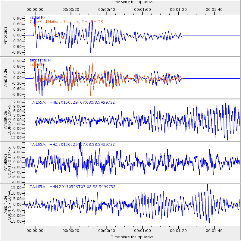
Signal To Noise
| Channel | StoN | STA | LTA |
| TA:L65A: :HHZ:20150529T07:08:58.549973Z | 2.5103633 | 2.0435657E-6 | 8.140517E-7 |
| TA:L65A: :HHN:20150529T07:08:58.549973Z | 1.9436746 | 2.1500357E-6 | 1.1061705E-6 |
| TA:L65A: :HHE:20150529T07:08:58.549973Z | 1.129635 | 1.5943556E-6 | 1.41139E-6 |
| Arrivals |
| Ps | 11 SECOND |
| PpPs | 31 SECOND |
| PsPs/PpSs | 42 SECOND |


