You are here: Home > Network List > SN - Southern Great Basin Network Stations List
> Station SPRS Specter Range SM and Rock Valley SPE wgs84 > Earthquake Result Viewer
SPRS Specter Range SM and Rock Valley SPE wgs84 - Earthquake Result Viewer
| Earthquake location: |
Bonin Islands, Japan Region |
| Earthquake latitude/longitude: |
27.8/140.5 |
| Earthquake time(UTC): |
2015/05/30 (150) 11:23:02 GMT |
| Earthquake Depth: |
678 km |
| Earthquake Magnitude: |
7.8 MWP, 8.5 MI |
| Earthquake Catalog/Contributor: |
NEIC PDE/NEIC COMCAT |
|
| Network: |
SN Southern Great Basin Network |
| Station: |
SPRS Specter Range SM and Rock Valley SPE wgs84 |
| Lat/Lon: |
36.69 N/116.18 W |
| Elevation: |
1092 m |
|
| Distance: |
83.6 deg |
| Az: |
51.918 deg |
| Baz: |
299.861 deg |
| Ray Param: |
0.04400749 |
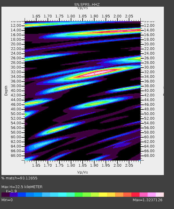
| Estimated Moho Depth: |
32.5 km |
| Estimated Crust Vp/Vs: |
1.90 |
| Assumed Crust Vp: |
6.279 km/s |
| Estimated Crust Vs: |
3.305 km/s |
| Estimated Crust Poisson's Ratio: |
0.31 |
|
| Radial Match: |
93.12655 % |
| Radial Bump: |
400 |
| Transverse Match: |
88.04435 % |
| Transverse Bump: |
400 |
| SOD ConfigId: |
7422571 |
| Insert Time: |
2019-04-19 03:16:16.859 +0000 |
| GWidth: |
2.5 |
| Max Bumps: |
400 |
| Tol: |
0.001 |
|

Signal To Noise
| Channel | StoN | STA | LTA |
| SN:SPRS: :HHZ:20150530T11:33:50.63498Z | 102.313385 | 7.3544754E-5 | 7.188185E-7 |
| SN:SPRS: :HHN:20150530T11:33:50.63498Z | 43.49842 | 1.764136E-5 | 4.055632E-7 |
| SN:SPRS: :HHE:20150530T11:33:50.63498Z | 19.715796 | 2.1409813E-5 | 1.0859218E-6 |
| Arrivals |
| Ps | 4.8 SECOND |
| PpPs | 15 SECOND |
| PsPs/PpSs | 19 SECOND |


