
Station SN SPRS - Specter Range SM and Rock Valley SPE wgs84
Network: SN - Southern Great Basin Network
Nearby stations (2 deg radius)

| Station | Name | (Lat, Lon) | Start / End | Elevation |
| SPRS | Specter Range SM and Rock Valley SPE wgs84 | (36.69, -116.18) | 1995-01-01 / 2599-12-31 | 1092 m |
| Crust2 Type: | M7,medium thick extended crust, 0.5 km seds. |
| Thickness Estimate: | 34 km |
| Thickness StdDev: | 1.1 km |
| Vp/Vs Estimate: | 1.84 |
| Vp/Vs StdDev: | 0.10 |
| Vs Estimate: | 3.408 km/s |
| Poisson's Ratio: | 0.29 |
| Peak Value: | 0.09 |
| Assumed Vp: | 6.279 km/s |
| Ps Weight: | 0.33333334 |
| PpPs Weight: | 0.33333334 |
| PsPs Weight: | 0.33333328 |
| Residual Complexity: | 0.525 |
| Nearby stations H: | +- |
| (2.0 deg) Vp/Vs: | +- |
2 with match > 90% ( 10.0 %) and 2 with match > 80% ( 10.0 %) out of 20.
Download stack as xyz text file.
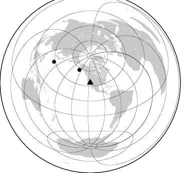
Azimuth Distribution of Events:
Prior Results for this Station
| Study | Thickness | Vp/Vs | Vp | Vs | Poissons Ratio | Extra |
| EARS | 34 km | 1.84 | 6.279 km/s | 3.408 km/s | 0.29 | |
| Crust2.0 | 35 km | 1.78 | 6.279 km/s | 3.533 km/s | 0.27 | M7,medium thick extended crust, 0.5 km seds. |
| Global Maxima | 34 km | 1.84 | 6.279 km/s | 3.408 km/s | 0.29 | amp=0.09069126 |
| Local Maxima 1 | 26 km | 2.10 | 6.279 km/s | 2.993 km/s | 0.35 | amp=0.057723124 |
| Local Maxima 2 | 26 km | 1.64 | 6.279 km/s | 3.823 km/s | 0.21 | amp=0.04968548 |
| Local Maxima 3 | 40 km | 1.73 | 6.279 km/s | 3.629 km/s | 0.25 | amp=0.041896783 |
| Local Maxima 4 | 50 km | 1.60 | 6.279 km/s | 3.924 km/s | 0.18 | amp=0.03237408 |
| Predicted Arrivals for vertical incidence (zero ray parameter) | |
| Ps | 4.50 SECOND |
| PpPs | 15.17 SECOND |
| PsPs/PpSs | 19.66 SECOND |
Events Processed for this Station
Download zip of receiver functions as SAC
Plot maxima for each earthquake.
Events Used in the Stack
(2 events)| Radial Match | Distance | Baz | FERegion | Time | Lat/Lon | Depth | Magnitude |
| 93.12655 | 83.6 deg | 299.861 deg | Bonin Islands, Japan Region | 2015/05/30 11:23:02 GMT | (27.8, 140.5) | 678 km | 7.8 MWP, 8.5 MI |
| 90.03741 | 33.5 deg | 319.64 deg | Alaska Peninsula | 2015/05/29 07:00:08 GMT | (56.7, -156.5) | 62 km | 6.8 MWP, 6.8 MI |
Losers
(18 events)| Radial Match | Distance | Baz | FERegion | Time | Lat/Lon | Depth | Magnitude | Reason |
| 73.5524 | 88.3 deg | 255.178 deg | Santa Cruz Islands Region | 2015/05/20 22:48:53 GMT | (-10.9, 164.2) | 12 km | 6.8 MWW, 6.7 MWB, 6.8 MWC, 6.9 MI | |
| 70.490456 | 92.5 deg | 262.622 deg | Solomon Islands | 2015/05/30 17:40:06 GMT | (-7.5, 156.2) | 44 km | 4.7 mb, 4.7 mb | |
| 70.44828 | 78.9 deg | 235.834 deg | Tonga Islands | 2015/05/20 00:30:51 GMT | (-19.3, -175.5) | 180 km | 6.0 MWP | |
| 68.40392 | 90.6 deg | 258.342 deg | Solomon Islands | 2015/05/21 19:32:57 GMT | (-9.8, 160.3) | 10 km | 6.0 MWB | |
| 67.66248 | 88.8 deg | 255.307 deg | Solomon Islands | 2015/05/22 21:45:18 GMT | (-11.1, 163.7) | 7.9 km | 6.8 MO | |
| 66.50395 | 70.0 deg | 310.365 deg | Kuril Islands | 2015/06/01 00:49:17 GMT | (44.1, 146.9) | 85 km | 4.2 mb | |
| 63.570816 | 79.3 deg | 236.145 deg | Tonga Islands | 2015/05/24 14:39:02 GMT | (-19.3, -175.9) | 35 km | 5.7 MB | |
| 58.79857 | 80.0 deg | 300.855 deg | Southeast Of Honshu, Japan | 2015/05/30 18:49:07 GMT | (30.8, 143.0) | 13 km | 6.4 MO | |
| 56.07754 | 75.0 deg | 236.894 deg | Tonga Islands | 2015/05/30 17:18:39 GMT | (-15.7, -173.3) | 51 km | 5.8 MB | |
| 50.50818 | 93.8 deg | 266.818 deg | New Britain Region, P.N.G. | 2015/05/23 19:28:18 GMT | (-4.8, 152.7) | 51 km | 5.7 MB | |
| 49.29754 | 84.1 deg | 231.63 deg | South Of Fiji Islands | 2015/05/25 10:01:45 GMT | (-25.9, -176.2) | 25 km | 5.2 MW, 5.3 mb, 4.5 MS | |
| 46.39434 | 83.5 deg | 299.828 deg | Bonin Islands, Japan Region | 2015/06/02 21:04:28 GMT | (27.9, 140.6) | 687 km | 4.9 mb | |
| 42.413372 | 81.6 deg | 237.937 deg | Fiji Islands Region | 2015/06/03 07:00:52 GMT | (-19.7, -179.0) | 669 km | 5.5 MW | |
| 35.981113 | 89.7 deg | 246.514 deg | Vanuatu Islands | 2015/05/19 13:54:55 GMT | (-18.6, 168.6) | 50 km | 5.8 MWB, 5.9 MWC | |
| 31.36762 | 66.6 deg | 311.513 deg | Kuril Islands | 2015/05/30 04:27:57 GMT | (46.7, 150.3) | 200 km | 4.1 mb, 3.8 mb | |
| 25.921862 | 81.8 deg | 231.904 deg | South Of Tonga Islands | 2015/05/24 09:47:20 GMT | (-24.1, -174.6) | 10 km | 4.8 mb, 4.7 mb, 3.4 MS | |
| 23.778006 | 73.8 deg | 134.358 deg | Northern Chile | 2015/05/26 10:32:01 GMT | (-22.1, -68.4) | 115 km | 5.7 MB | |
| 20.982576 | 91.7 deg | 189.276 deg | Pacific-Antarctic Ridge | 2015/05/19 15:25:21 GMT | (-54.4, -132.2) | 10 km | 6.7 MWW, 6.5 MWB, 6.6 MWC |

