You are here: Home > Network List > IC - New China Digital Seismograph Network Stations List
> Station HIA Hailar, Neimenggu Autonomous Region, China > Earthquake Result Viewer
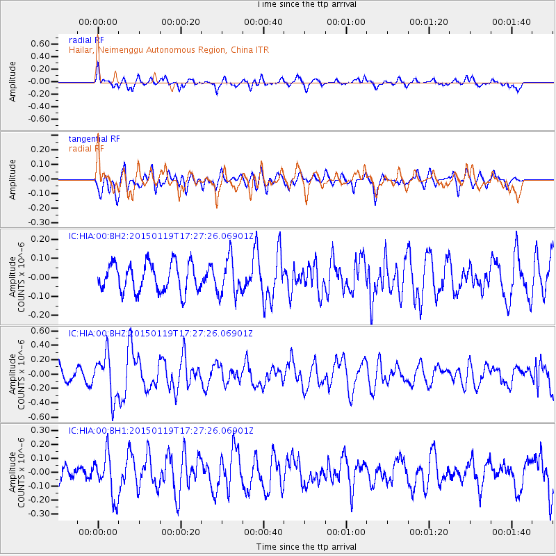
HIA Hailar, Neimenggu Autonomous Region, China - Earthquake Result Viewer
*The percent match for this event was below the threshold and hence no stack was calculated.
| Earthquake location: |
Sulu Archipelago, Philippines |
| Earthquake latitude/longitude: |
4.6/119.8 |
| Earthquake time(UTC): |
2015/01/19 (019) 17:19:45 GMT |
| Earthquake Depth: |
11 km |
| Earthquake Magnitude: |
5.5 MWB |
| Earthquake Catalog/Contributor: |
NEIC PDE/NEIC COMCAT |
|
| Network: |
IC New China Digital Seismograph Network |
| Station: |
HIA Hailar, Neimenggu Autonomous Region, China |
| Lat/Lon: |
49.27 N/119.74 E |
| Elevation: |
620 m |
|
| Distance: |
44.5 deg |
| Az: |
359.982 deg |
| Baz: |
179.972 deg |
| Ray Param: |
$rayparam |
*The percent match for this event was below the threshold and hence was not used in the summary stack. |
|
| Radial Match: |
74.857285 % |
| Radial Bump: |
400 |
| Transverse Match: |
53.45686 % |
| Transverse Bump: |
400 |
| SOD ConfigId: |
837871 |
| Insert Time: |
2015-02-02 17:32:28.880 +0000 |
| GWidth: |
2.5 |
| Max Bumps: |
400 |
| Tol: |
0.001 |
|
Signal To Noise
| Channel | StoN | STA | LTA |
| IC:HIA:00:BHZ:20150119T17:27:26.06901Z | 2.6188288 | 3.069806E-7 | 1.1722057E-7 |
| IC:HIA:00:BH1:20150119T17:27:26.06901Z | 3.3215528 | 1.6186948E-7 | 4.8733074E-8 |
| IC:HIA:00:BH2:20150119T17:27:26.06901Z | 1.346048 | 9.9392686E-8 | 7.3840376E-8 |
| Arrivals |
| Ps | |
| PpPs | |
| PsPs/PpSs | |


