You are here: Home > Network List > IC - New China Digital Seismograph Network Stations List
> Station HIA Hailar, Neimenggu Autonomous Region, China > Earthquake Result Viewer
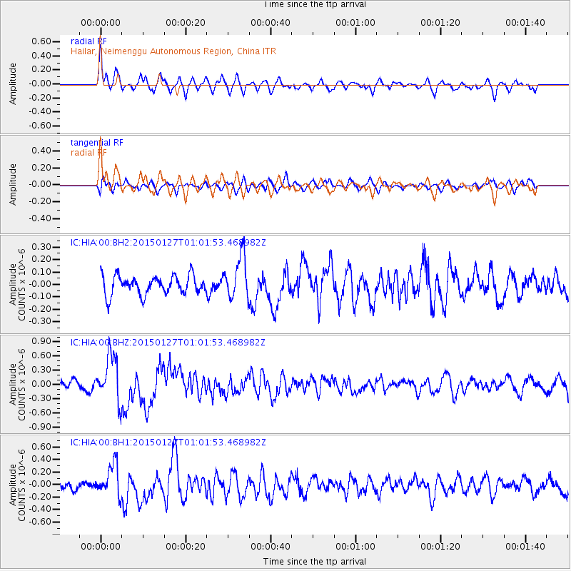
HIA Hailar, Neimenggu Autonomous Region, China - Earthquake Result Viewer
*The percent match for this event was below the threshold and hence no stack was calculated.
| Earthquake location: |
Northern Sumatra, Indonesia |
| Earthquake latitude/longitude: |
1.4/97.2 |
| Earthquake time(UTC): |
2015/01/27 (027) 00:53:19 GMT |
| Earthquake Depth: |
13 km |
| Earthquake Magnitude: |
5.6 MB, 5.7 MWB |
| Earthquake Catalog/Contributor: |
NEIC PDE/NEIC COMCAT |
|
| Network: |
IC New China Digital Seismograph Network |
| Station: |
HIA Hailar, Neimenggu Autonomous Region, China |
| Lat/Lon: |
49.27 N/119.74 E |
| Elevation: |
620 m |
|
| Distance: |
51.5 deg |
| Az: |
18.704 deg |
| Baz: |
209.304 deg |
| Ray Param: |
$rayparam |
*The percent match for this event was below the threshold and hence was not used in the summary stack. |
|
| Radial Match: |
72.620926 % |
| Radial Bump: |
400 |
| Transverse Match: |
52.17243 % |
| Transverse Bump: |
400 |
| SOD ConfigId: |
837871 |
| Insert Time: |
2015-02-10 01:10:20.312 +0000 |
| GWidth: |
2.5 |
| Max Bumps: |
400 |
| Tol: |
0.001 |
|
Signal To Noise
| Channel | StoN | STA | LTA |
| IC:HIA:00:BHZ:20150127T01:01:53.468982Z | 6.338278 | 5.076829E-7 | 8.009792E-8 |
| IC:HIA:00:BH1:20150127T01:01:53.468982Z | 4.553536 | 2.644205E-7 | 5.8069265E-8 |
| IC:HIA:00:BH2:20150127T01:01:53.468982Z | 2.340401 | 1.7785624E-7 | 7.599392E-8 |
| Arrivals |
| Ps | |
| PpPs | |
| PsPs/PpSs | |


