You are here: Home > Network List > IU - Global Seismograph Network (GSN - IRIS/USGS) Stations List
> Station TARA Tarawa Island, Republic of Kiribati > Earthquake Result Viewer
TARA Tarawa Island, Republic of Kiribati - Earthquake Result Viewer

| Earthquake location: |
Kermadec Islands Region |
| Earthquake latitude/longitude: |
-27.4/-176.3 |
| Earthquake time(UTC): |
2009/02/18 (049) 21:53:45 GMT |
| Earthquake Depth: |
25 km |
| Earthquake Magnitude: |
6.8 MB, 7.2 MS, 6.9 MW, 6.9 MW |
| Earthquake Catalog/Contributor: |
WHDF/NEIC |
|
| Network: |
IU Global Seismograph Network (GSN - IRIS/USGS) |
| Station: |
TARA Tarawa Island, Republic of Kiribati |
| Lat/Lon: |
1.35 N/172.92 E |
| Elevation: |
4.0 m |
|
| Distance: |
30.4 deg |
| Az: |
338.4 deg |
| Baz: |
160.895 deg |
| Ray Param: |
0.0793159 |
| Estimated Moho Depth: |
64.5 km |
| Estimated Crust Vp/Vs: |
1.82 |
| Assumed Crust Vp: |
4.802 km/s |
| Estimated Crust Vs: |
2.635 km/s |
| Estimated Crust Poisson's Ratio: |
0.28 |
|
| Radial Match: |
99.092705 % |
| Radial Bump: |
77 |
| Transverse Match: |
99.413216 % |
| Transverse Bump: |
60 |
| SOD ConfigId: |
2658 |
| Insert Time: |
2010-03-04 16:12:42.366 +0000 |
| GWidth: |
2.5 |
| Max Bumps: |
400 |
| Tol: |
0.001 |
|
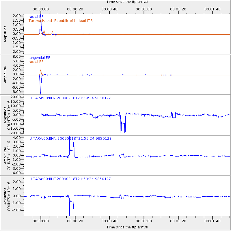
Signal To Noise
| Channel | StoN | STA | LTA |
| IU:TARA:00:BHN:20090218T21:59:24.985012Z | 3.4853876 | 2.4710982E-7 | 7.089881E-8 |
| IU:TARA:00:BHE:20090218T21:59:24.985012Z | 3.1361485 | 1.461735E-7 | 4.6609244E-8 |
| IU:TARA:00:BHZ:20090218T21:59:24.985012Z | 3.5046935 | 1.9739439E-6 | 5.6322864E-7 |
| Arrivals |
| Ps | 12 SECOND |
| PpPs | 36 SECOND |
| PsPs/PpSs | 48 SECOND |


