
Station IU TARA - Tarawa Island, Republic of Kiribati
Network: IU - Global Seismograph Network (GSN - IRIS/USGS)
Nearby stations (2 deg radius)
| Station | Name | (Lat, Lon) | Start / End | Elevation |
| TARA | Tarawa Island, Republic of Kiribati | (1.35, 172.92) | 2007-01-01 / 2499-01-01 | 0.0 km |
| Crust2 Type: | B0,melt affected o.c. and oceanic plateaus, 0.10 km seds. |
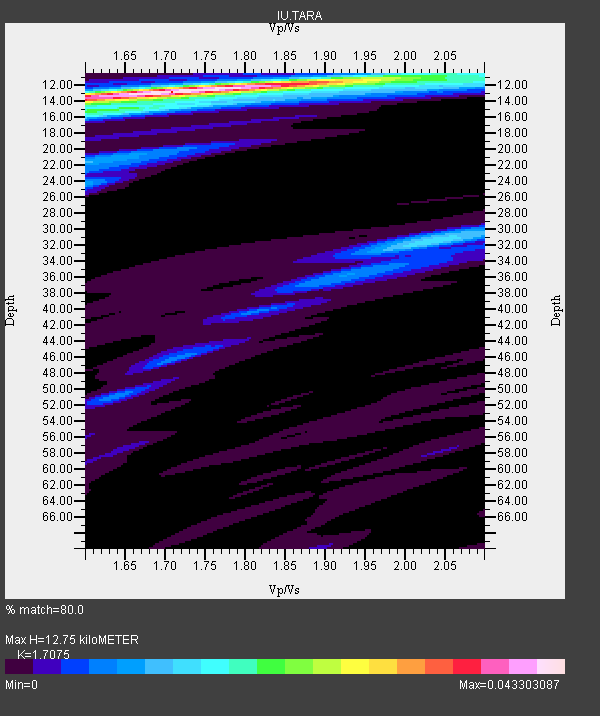
| Thickness Estimate: | 13 km |
| Thickness StdDev: | 4.8 km |
| Vp/Vs Estimate: | 1.71 |
| Vp/Vs StdDev: | 0.09 |
| Vs Estimate: | 2.812 km/s |
| Poisson's Ratio: | 0.24 |
| Peak Value: | 0.04 |
| Assumed Vp: | 4.802 km/s |
| Ps Weight: | 0.33333334 |
| PpPs Weight: | 0.33333334 |
| PsPs Weight: | 0.33333328 |
| Residual Complexity: | 0.402 |
| Nearby stations H: | +- |
| (2.0 deg) Vp/Vs: | +- |
5 with match > 90% ( 10.204082 %) and 10 with match > 80% ( 20.408163 %) out of 49.
Download stack as xyz text file.
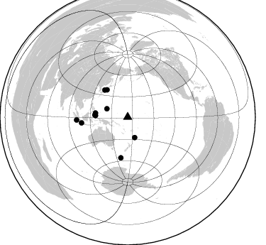
Azimuth Distribution of Events:
Prior Results for this Station
| Study | Thickness | Vp/Vs | Vp | Vs | Poissons Ratio | Extra |
| EARS | 13 km | 1.71 | 4.802 km/s | 2.812 km/s | 0.24 | |
| Crust2.0 | 16 km | 2.06 | 4.802 km/s | 2.335 km/s | 0.35 | B0,melt affected o.c. and oceanic plateaus, 0.10 km seds. |
| Global Maxima | 13 km | 1.71 | 4.802 km/s | 2.812 km/s | 0.24 | amp=0.043303087 |
| Local Maxima 1 | 15 km | 1.66 | 4.802 km/s | 2.897 km/s | 0.21 | amp=0.015330417 |
| Local Maxima 2 | 32 km | 2.03 | 4.802 km/s | 2.365 km/s | 0.34 | amp=0.012830068 |
| Local Maxima 3 | 12 km | 2.10 | 4.802 km/s | 2.289 km/s | 0.35 | amp=0.0116945505 |
| Local Maxima 4 | 24 km | 1.60 | 4.802 km/s | 3.001 km/s | 0.18 | amp=0.010120012 |
| Predicted Arrivals for vertical incidence (zero ray parameter) | |
| Ps | 1.88 SECOND |
| PpPs | 7.19 SECOND |
| PsPs/PpSs | 9.07 SECOND |
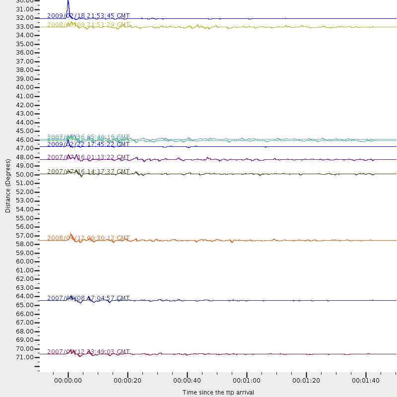
Events Processed for this Station
Download zip of receiver functions as SAC
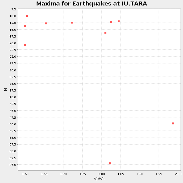
Plot maxima for each earthquake.
Events Used in the Stack
(10 events)| Radial Match | Distance | Baz | FERegion | Time | Lat/Lon | Depth | Magnitude |
| 99.092705 | 30.4 deg | 160.895 deg | Kermadec Islands Region | 2009/02/18 21:53:45 GMT | (-27.4, -176.3) | 25 km | 6.8 MB, 7.2 MS, 6.9 MW, 6.9 MW |
| 98.1823 | 46.4 deg | 273.766 deg | Talaud Islands, Indonesia | 2009/02/22 17:45:22 GMT | (3.7, 126.6) | 32 km | 5.9 MB, 5.7 MS, 6.0 MW, 6.0 MW |
| 96.68364 | 72.2 deg | 266.827 deg | Southern Sumatra, Indonesia | 2007/09/12 23:49:03 GMT | (-2.6, 100.8) | 35 km | 6.6 MB, 8.1 MS, 7.9 MW, 7.6 ME |
| 95.99726 | 65.5 deg | 262.912 deg | Java, Indonesia | 2007/08/08 17:04:57 GMT | (-5.9, 107.7) | 291 km | 6.1 MB |
| 92.350945 | 58.1 deg | 189.605 deg | Macquarie Island Region | 2008/04/12 00:30:12 GMT | (-55.7, 158.5) | 16 km | 6.8 MB, 7.1 MS, 7.1 MW, 7.1 MW |
| 89.30257 | 48.0 deg | 322.719 deg | Near West Coast Of Honshu, Japan | 2007/07/16 01:13:22 GMT | (37.5, 138.4) | 12 km | 6.5 MB, 6.4 MS, 6.6 MW, 6.5 MW |
| 88.71423 | 45.5 deg | 272.678 deg | Northern Molucca Sea | 2007/07/26 05:40:16 GMT | (2.9, 127.5) | 25 km | 6.4 MB, 6.8 MS, 6.9 MW, 6.9 MW |
| 86.38739 | 49.8 deg | 319.601 deg | Sea Of Japan | 2007/07/16 14:17:37 GMT | (36.8, 134.9) | 350 km | 6.2 MB, 6.8 MW, 6.8 MW |
| 84.02425 | 31.5 deg | 291.962 deg | South Of Mariana Islands | 2008/05/09 21:51:29 GMT | (12.5, 143.2) | 76 km | 6.1 MB, 6.7 MW, 6.7 MW |
| 82.7503 | 45.7 deg | 277.208 deg | Philippine Islands Region | 2007/08/20 13:46:17 GMT | (6.1, 127.4) | 8.0 km | 6.4 MB, 6.2 MS, 6.4 MW, 6.5 ME |
Losers
(39 events)| Radial Match | Distance | Baz | FERegion | Time | Lat/Lon | Depth | Magnitude | Reason |
| 97.78924 | 43.5 deg | 261.822 deg | Banda Sea | 2009/01/20 10:46:53 GMT | (-4.7, 129.8) | 144 km | 5.7 MB, 5.5 MW, 5.5 MW | |
| 95.21832 | 32.9 deg | 166.513 deg | Kermadec Islands, New Zealand | 2009/02/17 03:30:53 GMT | (-30.7, -178.6) | 13 km | 5.5 MS, 5.4 MB, 6.0 MW, 6.0 MW | |
| 80.51011 | 78.8 deg | 66.128 deg | Gulf Of California | 2009/01/05 10:59:30 GMT | (23.8, -108.8) | 10 km | 5.7 MB, 5.2 MS, 5.5 MW, 5.5 MW | |
| 78.140015 | 64.4 deg | 189.483 deg | Balleny Islands Region | 2009/02/18 03:30:34 GMT | (-61.7, 154.8) | 10 km | 5.7 MW, 5.2 MB | |
| 77.44632 | 45.2 deg | 323.558 deg | Near East Coast Of Honshu, Japan | 2008/05/07 16:45:20 GMT | (36.2, 141.5) | 39 km | 6.1 MB, 6.7 MS, 6.8 MW, 6.8 MW | |
| 74.61234 | 33.6 deg | 167.16 deg | Kermadec Islands Region | 2009/05/16 00:53:52 GMT | (-31.5, -178.8) | 55 km | 6.1 MB, 6.5 MW, 6.3 MW | |
| 73.732895 | 45.2 deg | 323.597 deg | Near East Coast Of Honshu, Japan | 2008/05/07 16:02:02 GMT | (36.2, 141.5) | 19 km | 5.7 MB, 6.2 MW, 6.2 MW | |
| 73.42194 | 72.0 deg | 265.442 deg | Southern Sumatra, Indonesia | 2008/08/08 06:37:41 GMT | (-3.9, 101.1) | 23 km | 5.5 MB, 5.5 MS, 5.8 MW, 5.8 MW | |
| 73.060646 | 46.3 deg | 274.158 deg | Talaud Islands, Indonesia | 2009/02/11 19:56:48 GMT | (4.0, 126.7) | 35 km | 5.5 MB | |
| 71.1941 | 51.1 deg | 6.605 deg | Andreanof Islands, Aleutian Is. | 2008/03/22 21:24:11 GMT | (52.2, -178.7) | 132 km | 5.8 MB, 6.2 MW, 6.1 MW | |
| 68.4537 | 54.4 deg | 257.835 deg | Sumba Region, Indonesia | 2009/07/13 10:52:20 GMT | (-9.1, 119.3) | 67 km | 5.7 MB, 5.9 MW, 5.9 MW | |
| 67.04315 | 65.8 deg | 213.261 deg | Western Indian-Antarctic Ridge | 2008/12/13 08:59:41 GMT | (-49.0, 123.5) | 10 km | 5.5 MB | |
| 65.50172 | 46.5 deg | 274.04 deg | Talaud Islands, Indonesia | 2009/02/11 17:34:50 GMT | (3.9, 126.4) | 22 km | 6.6 MB, 7.2 MS, 7.2 MW, 7.1 MW | |
| 63.04141 | 45.8 deg | 325.506 deg | Off East Coast Of Honshu, Japan | 2008/07/19 02:39:28 GMT | (37.6, 142.2) | 22 km | 6.2 MB, 7.0 MS, 7.0 MW, 6.9 MW | |
| 63.001728 | 81.1 deg | 280.798 deg | Andaman Islands, India Region | 2008/08/10 12:21:11 GMT | (10.9, 91.7) | 13 km | 5.7 MW, 5.4 MS, 5.4 MB, 5.6 MW | |
| 62.729984 | 70.7 deg | 303.674 deg | Sichuan, China | 2008/05/17 17:08:25 GMT | (32.2, 105.0) | 9.0 km | 5.8 MB, 5.6 MS, 5.7 MW, 5.7 MW | |
| 61.083515 | 53.4 deg | 258.849 deg | Flores Region, Indonesia | 2008/06/03 17:31:32 GMT | (-8.2, 120.3) | 14 km | 5.6 MB, 5.3 MS, 5.9 MW, 5.9 MW | |
| 60.21609 | 76.9 deg | 214.555 deg | Southeast Indian Ridge | 2008/12/08 18:39:09 GMT | (-53.0, 106.8) | 10 km | 6.2 MB, 5.9 MS, 6.3 MW, 6.3 MW | |
| 58.999947 | 41.7 deg | 317.669 deg | Southeast Of Honshu, Japan | 2008/05/30 07:25:39 GMT | (30.8, 141.5) | 16 km | 5.5 MB, 5.5 MS, 5.8 MW, 5.7 MW | |
| 58.112938 | 40.1 deg | 267.898 deg | Irian Jaya Region, Indonesia | 2009/01/03 21:49:30 GMT | (-0.3, 132.9) | 29 km | 5.6 MB | |
| 56.116356 | 94.2 deg | 75.523 deg | Near Coast Of Chiapas, Mexico | 2008/10/16 19:41:25 GMT | (14.4, -92.4) | 24 km | 6.1 MB, 6.6 MS, 6.7 MW, 6.6 MW | |
| 54.513134 | 48.8 deg | 259.02 deg | Banda Sea | 2008/12/06 10:55:27 GMT | (-7.4, 124.7) | 405 km | 6.1 MB, 6.4 MW, 6.4 MW | |
| 53.01409 | 48.1 deg | 325.314 deg | Eastern Honshu, Japan | 2008/04/16 19:19:36 GMT | (39.0, 140.0) | 166 km | 5.6 MB, 5.8 MW, 5.8 MW | |
| 52.420883 | 44.5 deg | 259.068 deg | Banda Sea | 2008/11/07 16:04:23 GMT | (-6.7, 129.1) | 10 km | 5.9 MB, 5.9 MS, 6.2 MW, 6.2 MW | |
| 51.086456 | 46.0 deg | 260.225 deg | Banda Sea | 2008/04/29 19:10:02 GMT | (-6.1, 127.5) | 405 km | 5.6 MB, 5.9 MW, 5.9 MW | |
| 49.968586 | 47.6 deg | 276.512 deg | Mindanao, Philippines | 2008/12/25 03:20:29 GMT | (5.8, 125.4) | 211 km | 6.1 MB, 6.3 MW, 6.3 MW | |
| 48.736057 | 92.7 deg | 228.991 deg | Mid-Indian Ridge | 2008/05/31 04:37:56 GMT | (-41.2, 80.5) | 10 km | 6.0 MB, 6.3 MS, 6.4 MW, 6.4 MW | |
| 48.406918 | 71.5 deg | 263.778 deg | Southwest Of Sumatra, Indonesia | 2009/07/28 08:43:44 GMT | (-5.5, 101.7) | 10 km | 5.6 MB, 5.5 MS, 5.6 MW, 5.6 MW | |
| 47.30247 | 55.0 deg | 323.648 deg | E. Russia-N.E. China Border Reg. | 2008/05/19 10:08:36 GMT | (42.5, 131.9) | 513 km | 5.7 MW, 5.4 MB, 5.6 MW | |
| 46.133305 | 33.6 deg | 262.658 deg | Near North Coast Of Irian Jaya | 2009/03/28 17:59:32 GMT | (-3.0, 139.5) | 96 km | 5.8 MB, 6.0 MW, 6.0 MW | |
| 44.327236 | 53.7 deg | 329.338 deg | Primor'ye, Russia | 2008/06/29 20:53:01 GMT | (45.2, 137.4) | 287 km | 5.6 MB, 6.0 MW, 5.9 MW | |
| 44.19275 | 63.3 deg | 193.082 deg | West Of Macquarie Island | 2008/06/01 14:31:03 GMT | (-59.4, 149.7) | 10 km | 5.8 MB, 6.3 MS, 6.5 MW, 6.5 MW | |
| 43.612316 | 70.4 deg | 304.299 deg | Sichuan, China | 2008/08/05 09:49:17 GMT | (32.8, 105.5) | 6.0 km | 5.9 MB, 6.0 MS, 6.0 MW, 5.9 MW | |
| 43.089493 | 48.0 deg | 335.309 deg | Kuril Islands | 2008/04/12 00:46:28 GMT | (43.9, 147.5) | 64 km | 5.7 MB | |
| 42.321033 | 70.8 deg | 302.692 deg | Sichuan, China | 2008/05/12 06:42:08 GMT | (31.3, 104.7) | 10 km | 5.7 MB | |
| 40.039425 | 51.8 deg | 348.598 deg | Near East Coast Of Kamchatka | 2008/09/18 11:58:50 GMT | (51.9, 158.4) | 67 km | 5.7 MB, 5.9 MW, 5.8 MW | |
| 39.1341 | 85.2 deg | 354.575 deg | North Of Severnaya Zemlya | 2008/08/13 08:35:02 GMT | (83.6, 115.2) | 10 km | 5.5 MB, 4.7 MS, 5.4 MW, 5.4 MW | |
| 38.542774 | 32.6 deg | 165.129 deg | Kermadec Islands, New Zealand | 2008/11/25 01:36:30 GMT | (-30.2, -177.9) | 35 km | 5.6 MB, 5.3 MS, 5.6 MW, 5.6 MW | |
| 34.929226 | 33.9 deg | 165.721 deg | Kermadec Islands Region | 2008/09/04 16:09:51 GMT | (-31.6, -177.8) | 26 km | 5.5 MB, 5.9 MS, 5.8 MW, 5.7 MW |
