You are here: Home > Network List > IU - Global Seismograph Network (GSN - IRIS/USGS) Stations List
> Station TARA Tarawa Island, Republic of Kiribati > Earthquake Result Viewer
TARA Tarawa Island, Republic of Kiribati - Earthquake Result Viewer
| Earthquake location: |
Macquarie Island Region |
| Earthquake latitude/longitude: |
-55.7/158.5 |
| Earthquake time(UTC): |
2008/04/12 (103) 00:30:12 GMT |
| Earthquake Depth: |
16 km |
| Earthquake Magnitude: |
6.8 MB, 7.1 MS, 7.1 MW, 7.1 MW |
| Earthquake Catalog/Contributor: |
WHDF/NEIC |
|
| Network: |
IU Global Seismograph Network (GSN - IRIS/USGS) |
| Station: |
TARA Tarawa Island, Republic of Kiribati |
| Lat/Lon: |
1.35 N/172.92 E |
| Elevation: |
4.0 m |
|
| Distance: |
58.1 deg |
| Az: |
17.121 deg |
| Baz: |
189.605 deg |
| Ray Param: |
0.06308225 |
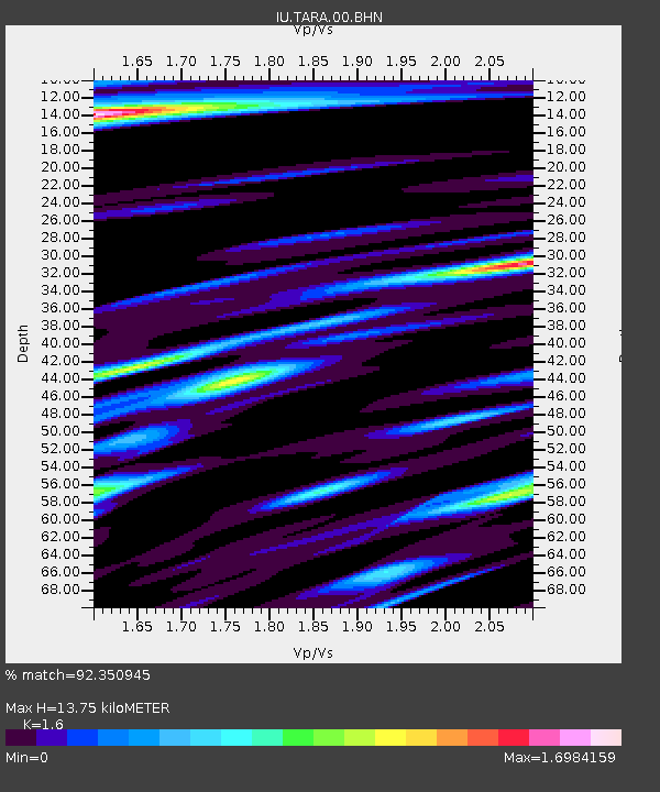
| Estimated Moho Depth: |
13.75 km |
| Estimated Crust Vp/Vs: |
1.60 |
| Assumed Crust Vp: |
4.802 km/s |
| Estimated Crust Vs: |
3.001 km/s |
| Estimated Crust Poisson's Ratio: |
0.18 |
|
| Radial Match: |
92.350945 % |
| Radial Bump: |
400 |
| Transverse Match: |
92.58841 % |
| Transverse Bump: |
400 |
| SOD ConfigId: |
2504 |
| Insert Time: |
2010-03-04 16:12:46.405 +0000 |
| GWidth: |
2.5 |
| Max Bumps: |
400 |
| Tol: |
0.001 |
|

Signal To Noise
| Channel | StoN | STA | LTA |
| IU:TARA:00:BHN:20080412T00:39:33.722009Z | 25.649618 | 1.1186142E-5 | 4.361134E-7 |
| IU:TARA:00:BHE:20080412T00:39:33.722009Z | 9.265935 | 8.883072E-6 | 9.586806E-7 |
| IU:TARA:00:BHZ:20080412T00:39:33.722009Z | 2.743533 | 2.4727808E-6 | 9.013126E-7 |
| Arrivals |
| Ps | 1.8 SECOND |
| PpPs | 7.2 SECOND |
| PsPs/PpSs | 9.0 SECOND |


